


Georgia Weather Alert: Flash Flood Watches, Coastal Hazards, and Flood Warnings Impact the State
Georgia residents are facing multiple weather threats as heavy tropical moisture associated with the remnants of Tropical Storm Arthur continues to move across the Southeast. Flood Watches, Flash Flood Warnings, Coastal Hazards, and excessive rainfall concerns remain active across portions of the state, creating dangerous travel conditions and increasing the risk of flooding in both inland and coastal communities. Recent rounds of thunderstorms have already produced significant rainfall totals, saturated soils, and rapidly rising waterways. (National Weather Service)
Flash Flood Watches Continue Across Central and Southern Georgia
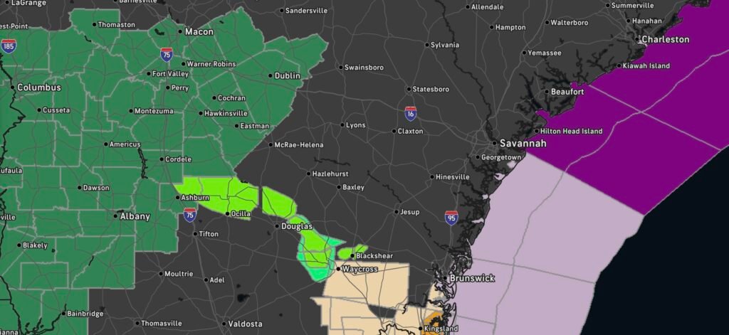
The National Weather Service has extended Flood Watches across large portions of central, west-central, and east-central Georgia through late tonight. Counties including Bibb, Houston, Laurens, Muscogee, Sumter, Crawford, Dodge, Pulaski, and surrounding areas remain under heightened flood concerns due to repeated rounds of heavy rainfall. Forecasters warn that excessive rainfall falling on already saturated ground could quickly lead to flash flooding of roads, neighborhoods, streams, and low-lying areas. (National Weather Service)
Rainfall rates have been intense at times, with tropical moisture producing training thunderstorms capable of dropping several inches of rain within a short period. This setup dramatically increases the risk of flash flooding, especially in urban areas where drainage systems can quickly become overwhelmed. (The Washington Post)
Active Flash Flood Warnings Issued
Flash Flood Warnings have already been issued in portions of south-central Georgia, including Ben Hill, Irwin, and Turner counties. Radar estimates indicate several inches of rain have fallen, with additional rainfall expected. Flooding of creeks, streams, highways, underpasses, and poor drainage areas has either been reported or is expected to develop rapidly. (National Weather Service)
Meteorologists continue to emphasize that flash flooding can develop with little warning. Conditions can change rapidly during heavy rainfall events, particularly during nighttime hours when flooded roadways are harder to identify.
Coastal Georgia Facing Additional Hazards
Along Georgia’s coastline, periods of heavy rainfall combined with elevated tides are increasing coastal flooding concerns. Coastal communities from Glynn County southward toward the Florida border have seen Flood Advisories issued due to excessive rainfall and poor drainage flooding. Areas near tidal rivers, marshes, and low-lying coastal roads remain vulnerable to water accumulation. (National Weather Service)
Strong onshore flow and persistent tropical moisture may also lead to hazardous marine conditions, rough surf, dangerous rip currents, and localized coastal flooding during periods of high tide. Residents and visitors should closely monitor local advisories before heading to beaches or waterfront areas.
Tropical Moisture from Arthur Continues to Fuel Severe Weather
Although Arthur has weakened significantly, the system’s tropical moisture remains a major concern. The greatest threat across Georgia is no longer wind, but rather excessive rainfall capable of producing life-threatening flooding. Forecasts indicate widespread rainfall totals of 2 to 5 inches across portions of the state, with isolated higher amounts possible where thunderstorms repeatedly move over the same areas. (New York Post)
In addition to flooding, some thunderstorms may produce:
- Frequent lightning
- Gusty winds
- Isolated severe weather
- Brief tornadoes embedded within rain bands
- Reduced visibility during heavy downpours
The Weather Prediction Center continues to highlight portions of Georgia for excessive rainfall concerns as the tropical moisture plume remains in place. (NCEP Web Portal)
Rivers, Creeks, and Streams Under Close Watch
Hydrologists are monitoring numerous waterways across Georgia as runoff continues from recent rainfall. Small streams and creeks can rise quickly during flash flood events, while larger rivers may experience delayed flooding after rainfall has ended. Areas that have experienced repeated heavy rainfall over the past several days are especially vulnerable to additional flooding. (Wikipedia)
Residents living near rivers, creeks, and flood-prone locations should stay alert for changing conditions and possible additional Flood Warnings.
Safety Actions Georgia Residents Should Take
As severe weather continues across the state, officials urge residents to remain weather aware and prepared.
Flood Safety Tips
- Never drive through flooded roadways.
- Turn Around, Don’t Drown.
- Move to higher ground if flooding develops.
- Monitor local weather alerts throughout the day and overnight.
- Keep mobile devices charged in case of power outages.
- Avoid recreational activities near swollen rivers and streams.
- Have multiple ways to receive emergency alerts.
Looking Ahead
While some areas may begin to see improving conditions this weekend, flooding concerns will continue as rivers respond to recent rainfall and additional showers remain possible. Georgia residents should remain alert for changing forecasts, Flood Warnings, Flash Flood Warnings, and Coastal Hazard Statements as conditions evolve.
The combination of saturated soils, tropical moisture, and additional thunderstorms means the flood threat is far from over. Staying informed and taking weather warnings seriously will be critical over the next 24 to 48 hours. (ajc)