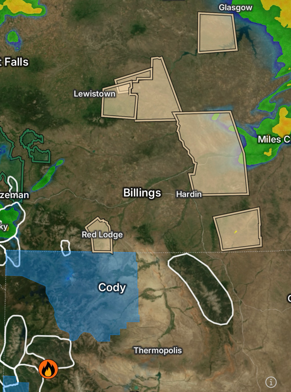
Kinky Creek Wildfire Situation Update
The Kinky Creek Wildfire continues to impact portions of northwestern Wyoming and nearby Montana border zones, where rugged terrain, dry fuels, and shifting weather patterns are influencing fire behavior.
Fire activity remains concentrated in remote, forested, and mountainous areas where access is limited and suppression efforts are heavily dependent on aerial support and weather conditions. While containment progress may fluctuate depending on operational reports and recent precipitation, the fire continues to require active monitoring due to spot fire potential and changing wind patterns.
Key concerns across the fire zone include:
- Dry timber and mixed fuels in elevated terrain
- Difficult ground access in wilderness areas
- Wind-driven flare-ups in exposed ridgelines
- Smoke impacts in nearby valleys and rural communities
Fire crews continue focusing on containment lines, hotspot suppression, and protecting nearby infrastructure where applicable.
Park County Power Outage Update (Wyoming)
Park County, Wyoming, has experienced localized power outages, primarily linked to severe weather activity, including lightning and wind impacts associated with nearby thunderstorm development.
While outages are not widespread across the entire county, rural zones are often more vulnerable due to:
- Long transmission distances
- Limited redundancy in power infrastructure
- Weather exposure in mountainous terrain
Impacts from outages may include:
- Temporary loss of communications in remote areas
- Water system disruptions for well-dependent households
- Delays in emergency response coordination during storms
Utility crews are typically working in coordination with weather conditions to restore service safely as storms move through the region.
Severe Thunderstorm Activity Across Wyoming & Montana
A broad and active thunderstorm pattern is developing across portions of Wyoming and Montana, producing lightning, gusty winds, and scattered heavy rainfall. These storms are interacting with dry fuels in some areas while providing localized relief in others.
Southeastern Carbon County (WY) & Southwestern Bighorn County (MT)
Thunderstorms in this region are producing:
- Frequent lightning strikes
- Gusty, shifting winds
- Brief but intense rainfall bursts
These conditions may temporarily reduce fire intensity but also increase new ignition risk from lightning activity.
Southeastern Bighorn County (MT) & Southern Rosebud County (MT)
Storm cells moving through this corridor may bring:
- Isolated strong thunderstorms
- Wind gusts capable of downing small branches
- Patchy rainfall coverage
Lightning remains the primary concern for both fire starts and safety hazards.
North Central Bighorn County (MT) & Northern Rosebud County (MT)
This area is seeing more organized thunderstorm development with:
- Frequent lightning activity
- Short-duration heavy rainfall
- Localized reduced visibility in storm cores
While rainfall may be beneficial, lightning continues to pose a wildfire ignition risk across dry terrain.
Southwestern Phillips County (MT), Petroleum County (MT) & Southwestern Garfield County (MT)
Scattered storms are moving through open plains and mixed terrain, bringing:
- Dry lightning potential in some storm cells
- Gusty outflow winds
- Rapid shifts from calm to stormy conditions
These regions remain sensitive due to grassland fuels and open exposure.
North Central Garfield County (MT) & Southwestern Valley County (MT)
Thunderstorms here may include:
- Moderate rainfall pockets
- Lightning across elevated terrain
- Brief wind surges during storm collapse
Travel and outdoor activity may be impacted by rapidly changing conditions.
Combined Hazards: Fire, Storms & Infrastructure Stress
The overlap of wildfire activity, thunderstorms, and intermittent power outages creates a complex hazard scenario across portions of Wyoming and Montana:
- Lightning increases wildfire ignition potential
- Wind gusts can spread fire activity or damage power lines
- Rainfall may temporarily slow fire behavior but increase slick terrain risks
- Rural infrastructure remains vulnerable to both fire and storm impacts
Safety Guidance for Residents
Residents across affected regions should remain alert and prepared:
- Charge all essential devices before storms arrive
- Avoid outdoor exposure during lightning activity
- Keep emergency lighting and backup power available
- Monitor wildfire and weather alerts frequently
- Be prepared for road delays or sudden visibility reductions
Final Thoughts
The Kinky Creek wildfire region across Wyoming and Montana, combined with active thunderstorm development, continues to present a dynamic and rapidly changing environment. While scattered rainfall may provide brief suppression benefits, ongoing lightning activity and gusty winds maintain elevated risk for both wildfire spread and new ignitions.
Residents and travelers across these counties should continue to monitor official wildfire updates and National Weather Service alerts as conditions evolve through the region.
Radar Watch HQ Top 5 Essential Emergency Preparedness Picks
Affiliate Disclosure: As an Amazon Associate, Radar Watch HQ earns from qualifying purchases.
Whether you’re preparing for severe thunderstorms, flash flooding, hurricanes, wildfires, or extended power outages, these five emergency essentials can help keep your household safer when severe weather strikes.
A portable power station provides reliable backup electricity during outages, allowing you to power phones, medical devices, laptops, lights, small appliances, and communication equipment without fuel.
Best for:
- Extended power outages
- Severe thunderstorms
- Hurricanes
- Winter storms
- Wildfires
2. Flood Protection Barriers & Sandless Flood Bags
Flood barriers help divert or absorb water before it enters garages, doorways, and low-lying areas. They deploy quickly and can help reduce property damage during flash flooding.
Best for:
- Flash Flood Warnings
- Heavy rainfall
- River flooding
- Coastal flooding
3. Rechargeable LED Flashlights
Bright, dependable flashlights are essential when the power goes out. Rechargeable or solar-powered models provide long-lasting illumination for navigating safely indoors and outdoors.
Best for:
- Overnight power outages
- Emergency evacuations
- Storm damage inspections
Keep phones, tablets, weather radios, and USB-powered devices charged when the electrical grid is unavailable. A solar power bank offers an additional charging option during prolonged emergencies.
Best for:
- Communication during outages
- Emergency weather alerts
- Travel and evacuation
A NOAA Weather Radio delivers official weather alerts directly from the National Weather Service, even when cellular networks or internet service are unavailable. It remains one of the most dependable ways to receive life-saving warnings.
Best for:
- Tornado warnings
- Severe thunderstorm warnings
- Flash flood warnings
- Hurricane alerts
- Winter storm emergencies
Why Radar Watch HQ Recommends These Essentials
At Radar Watch HQ, preparedness is just as important as staying informed. These five emergency essentials can help you stay connected, protect your property, and safely navigate severe weather events. Having supplies ready before storms arrive allows you to respond quickly when warnings are issued and conditions begin to deteriorate.