


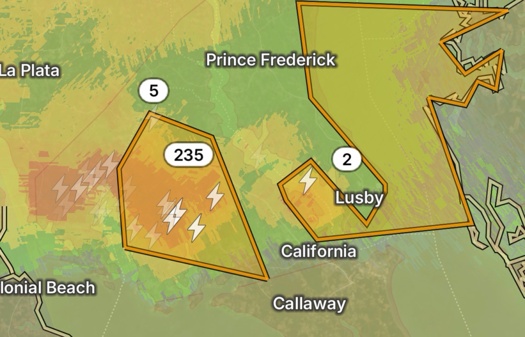
SPECIAL MARINE WARNING & HAZARDOUS WEATHER OUTLOOK ISSUED FOR MECHANICSVILLE & VIENNA, MARYLAND
A Special Marine Warning along with a Hazardous Weather Outlook has been issued for portions of the Chesapeake Bay and surrounding tidal waters impacting areas near Mechanicsville, MD and Vienna, MD, signaling potentially dangerous conditions for mariners and coastal communities.
⚠️ Marine and Weather Hazards Developing
The National Weather Service has highlighted increasing atmospheric instability across the Chesapeake Bay region, with thunderstorms capable of producing hazardous marine conditions, including:
- Sudden wind gusts over open waters
- Rapidly changing wave heights
- Frequent lightning activity
- Brief but intense downbursts capable of impacting small craft
A Special Marine Warning is typically issued when thunderstorms pose an immediate threat to boaters, especially those operating smaller vessels or near shallow tidal waters.
🌊 Areas Affected
Communities and waters near:
- Mechanicsville, Maryland
- Vienna, Maryland
- Lower Potomac River
- Portions of the Chesapeake Bay and surrounding tributaries
Mariners in these areas should remain alert for fast-developing storms that may move quickly across the water.
🌩️ Hazardous Weather Outlook Details
The broader Hazardous Weather Outlook indicates that conditions remain favorable for scattered thunderstorms capable of:
- Strong, gusty winds over land and water
- Frequent lightning strikes
- Heavy downpours reducing visibility
- Isolated pockets of severe weather development
According to National Weather Service marine outlooks for the region, even non-severe storms can rapidly intensify over tidal waters, creating sudden dangerous boating conditions.
🚤 Marine Safety Concerns
Boaters and coastal residents should be aware that Chesapeake Bay conditions can change rapidly when thunderstorms approach. Key risks include:
- “Pop-up” storms forming along sea breeze boundaries
- Wind shifts that can capsize small vessels
- Reduced radar visibility in heavy rainfall
- Dangerous conditions developing within minutes
A recent pattern of hazardous marine weather across the region has included wind gusts reaching 20–25 knots in advisory conditions, highlighting how quickly conditions can deteriorate.
🛑 Safety Recommendations
If you are on or near the water:
- Head to shore immediately if storms are approaching
- Avoid boating until warnings are lifted
- Secure small craft and dock equipment
- Monitor NOAA Weather Radio or official NWS updates
- Stay indoors during lightning activity
Even after the warning expires, lingering gusty winds and unstable conditions may persist.
🌦️ Outlook Ahead
The Hazardous Weather Outlook suggests that while immediate marine hazards may ease after storms pass, additional rounds of thunderstorms remain possible depending on atmospheric development over the coming days.
📍 Bottom Line
Mechanicsville and Vienna, MD remain under a heightened marine weather threat, with thunderstorms capable of producing sudden dangerous conditions over the Chesapeake Bay and surrounding waterways.
Residents and mariners should stay weather-aware, as conditions may change quickly with little warning.