Current Situation
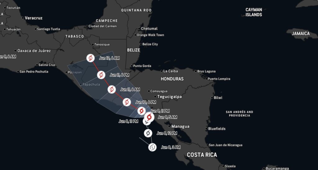
Tropical Storm Cristina formed in the Eastern Pacific Ocean on June 8, 2026, just offshore of Nicaragua and El Salvador. The storm became the third named storm of the 2026 Eastern Pacific hurricane season and is producing heavy rainfall across portions of Central America.
As of the latest National Hurricane Center advisory:
- Maximum sustained winds: 45 mph
- Movement: North at 5 mph
- Minimum central pressure: 1002 mb
- Location: Just offshore of Nicaragua and El Salvador in the Eastern Pacific Ocean.
Areas at Risk
Highest Impact Areas
Nicaragua
El Salvador
Guatemala
Honduras
Forecasters expect widespread rainfall totals of 4 to 8 inches, with isolated amounts approaching 12 inches. The greatest threat is flash flooding and mudslides, especially in mountainous terrain.
Forecast Track
Cristina is expected to move generally northward before turning west-northwest and paralleling the Central American coastline. The storm may remain offshore for several days before eventually approaching Guatemala later this week.
While significant strengthening is not currently expected, the storm’s slow movement could prolong heavy rainfall across the region.
Main Hazards
🌧️ Flash Flooding
⛰️ Mudslides and Landslides
🌊 Dangerous Coastal Conditions
⚡ Frequent Tropical Thunderstorms
The rainfall threat is expected to be more significant than the wind threat for most communities.
Weather Intelligence Center Analysis
Cristina is another example of the active start to the Eastern Pacific hurricane season. The storm follows Tropical Storm Amanda and Tropical Storm Boris, highlighting a favorable environment for tropical development across the Eastern Pacific basin during early June.