Severe Thunderstorm Warnings Issued for Bath, Fleming, and Rowan Counties, Kentucky, While Northeastern Montgomery County Warning Cancelled
A volatile and high-energy weather setup is making its presence felt across eastern Kentucky. Severe thunderstorm cells capable of producing destructive winds, heavy downpours, and frequent cloud-to-ground lightning have prompted urgent action from the National Weather Service (NWS). While parts of the region remain under an active threat, other areas are beginning to see the immediate danger clear. Residents across the Bluegrass State need to stay vigilant as fast-moving storms track through the area.
Fast Facts: Kentucky Severe Thunderstorm Alerts
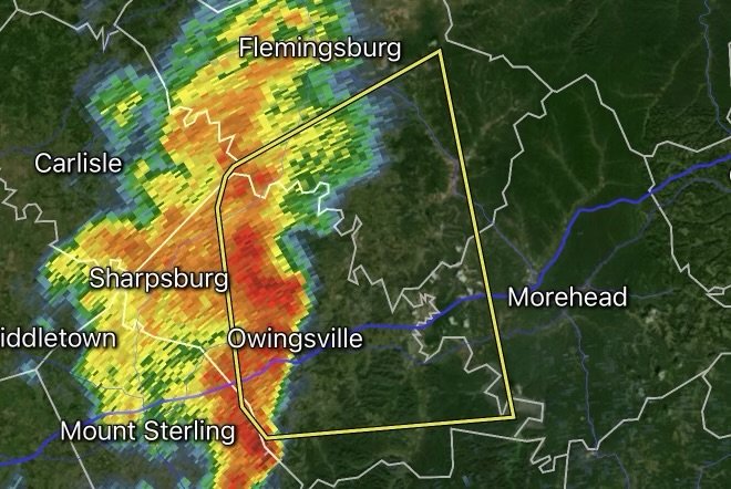
Active Severe Thunderstorm Warnings: Bath County, Fleming County, and Rowan County, Kentucky.
Cancelled Warnings: The severe thunderstorm warning previously in effect for northeastern Montgomery County has been officially cancelled as the core storm cell moved out of the area or weakened below severe thresholds.
Core Hazards: Damaging straight-line winds, heavy rainfall reducing visibility, frequent cloud-to-ground lightning, and localized gusty winds.
Action Required: Seek shelter in a sturdy permanent building immediately; stay away from windows and avoid flooded roadways.
Understanding the Storm Track and Current Alerts
Severe weather can develop with little warning during peak summer storm cycles, catching communities off guard. The latest radar updates and bulletins from the NWS show persistent storm cells tracking across eastern Kentucky.
While northeastern Montgomery County has received an all-clear with its severe thunderstorm warning officially cancelled, the threat is far from over for neighboring communities. Residents in Bath, Fleming, and Rowan counties remain directly in the path of active storms. Whether you live in Owingsville, Flemingsburg, Morehead, or surrounding rural stretches, keeping informed and knowing how to respond when a warning flashes across your phone is vital.
Safety Checklist: How to Protect Your Property and Family
When a Severe Thunderstorm Warning is active for your area, every minute counts. Follow these essential safety guidelines to keep yourself and your loved ones protected:
Move Indoors Immediately: As the saying goes, “When thunder roars, go indoors.” Do not wait until the rain starts to seek safe shelter inside a sturdy permanent building.
Secure Outdoor Objects: High winds can turn patio furniture, garbage cans, trampolines, and unanchored lawn decorations into dangerous projectiles. Bring them inside or tie them down securely.
Stay Away from Windows: Flying glass is a major hazard during high wind gusts. Move to an interior room on the lowest floor of a sturdy building (such as a bathroom, closet, or hallway).
Never Drive Through Flooded Roads: Turn Around, Don’t Drown! Just a few inches of fast-moving water can sweep away a standard vehicle. Low-water crossings and rural roads can submerge rapidly under torrential downpours.
Prepare for Power Outages: Keep flashlights, extra batteries, and fully charged mobile devices close by in case local power grids experience disruptions from high winds or lightning strikes.
Stay Informed
Weather conditions across eastern Kentucky can shift in a matter of minutes. Always keep a NOAA Weather Radio tuned to your local frequency or enable emergency alerts on your smartphone to receive real-time updates directly from your regional National Weather Service office. Stay safe, stay alert, and look out for your neighbors!
Affiliate Disclosure: As an Amazon Associate, Radar Watch HQ earns from qualifying purchases.
Radar Watch HQ Top 5 Essential Emergency Preparedness Picks
Whether you’re preparing for severe thunderstorms, flash flooding, hurricanes, wildfires, or extended power outages, these five emergency essentials can help keep your household safer when severe weather strikes.
A portable power station provides reliable backup electricity during outages, allowing you to power phones, medical devices, laptops, lights, small appliances, and communication equipment without fuel.
Best for:
- Extended power outages
- Severe thunderstorms
- Hurricanes
- Winter storms
- Wildfires
2. Flood Protection Barriers & Sandless Flood Bags
Flood barriers help divert or absorb water before it enters garages, doorways, and low-lying areas. They deploy quickly and can help reduce property damage during flash flooding.
Best for:
- Flash Flood Warnings
- Heavy rainfall
- River flooding
- Coastal flooding
3. Rechargeable LED Flashlights
Bright, dependable flashlights are essential when the power goes out. Rechargeable or solar-powered models provide long-lasting illumination for navigating safely indoors and outdoors.
Best for:
- Overnight power outages
- Emergency evacuations
- Storm damage inspections
Keep phones, tablets, weather radios, and USB-powered devices charged when the electrical grid is unavailable. A solar power bank offers an additional charging option during prolonged emergencies.
Best for:
- Communication during outages
- Emergency weather alerts
- Travel and evacuation
A NOAA Weather Radio delivers official weather alerts directly from the National Weather Service, even when cellular networks or internet service are unavailable. It remains one of the most dependable ways to receive life-saving warnings.
Best for:
- Tornado warnings
- Severe thunderstorm warnings
- Flash flood warnings
- Hurricane alerts
- Winter storm emergencies
Why Radar Watch HQ Recommends These Essentials
At Radar Watch HQ, preparedness is just as important as staying informed. These five emergency essentials can help you stay connected, protect your property, and safely navigate severe weather events. Having supplies ready before storms arrive allows you to respond quickly when warnings are issued and conditions begin to deteriorate.