Henry Fire Reaches 70% Containment Near Paulina, Oregon: Evacuation Orders and Progress Update
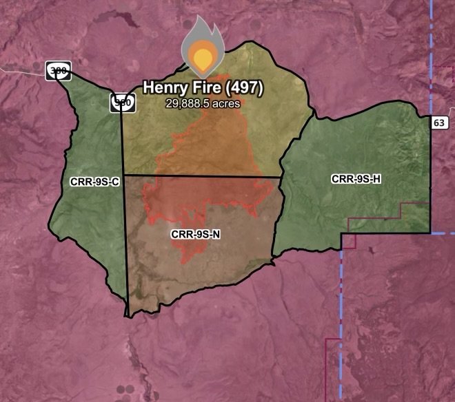
A significant firefighting milestone has been reached in central Oregon as interagency crews make steady progress against the Henry Fire (Fire 497). Burning approximately 1.7 miles south of Paulina in Crook County, the persistent blaze has now scorched 29,88.5 acres while pushing containment up to a notable 70%.
Despite the encouraging containment gains, local emergency management and fire officials stress that active threats remain. Mandatory evacuation orders stay in effect for affected zones as crews work diligently to secure the remaining perimeter and suppress lingering hot spots under challenging high-desert weather conditions.
Fast Facts: Henry Fire Status (August 1, 2026)
Incident Name: Henry Fire (Fire 497)
Date of Update: August 1, 2026
Location: Approximately 1.7 miles south of Paulina, Crook County, Oregon
Size: 29,88.5 acres
Containment: 70%
Current Status: Active suppression and mop-up operations under active Red Flag Warning conditions
Challenging Conditions and Red Flag Warnings
Firefighters managing the Henry Fire face heightened environmental hurdles. Regional weather forecasts have triggered active Red Flag Warnings across central Oregon, bringing dangerous combinations of low relative humidity, high ambient temperatures, and strong, gusty winds. These severe meteorological conditions test containment lines and increase the risk of spot fires or flare-ups within interior unburnt pockets, particularly around rugged terrain features like Bedell Canyon.
Essential Wildfire Safety Checklist
Heed Evacuation Orders Instantly: If local authorities or emergency management tell you to evacuate, do not delay. Gather your emergency go-bag, essential medications, pets, and important documents, and leave immediately via designated safe routes.
Protect Respiratory Health: Lingering smoke from the Henry Fire and regional blazes continues to degrade local air quality. Keep windows and doors tightly sealed, and utilize HEPA indoor air filtration systems if you are outside the immediate evacuation footprint.
Monitor Official Channels: Keep a battery-operated or NOAA weather radio tuned to emergency frequencies, and continuously monitor real-time evacuation maps provided by Crook County Emergency Management and platforms like Watch Duty.
Avoid Non-Essential Travel: Refrain from driving on rural highways and backcountry roads near Paulina to keep roadways clear for arriving fire engines, water tenders, and heavy equipment.
Stay Informed
Weather conditions, wind shifts, and fire behavior can change rapidly across the high desert terrain of Crook County. For the most up-to-the-minute evacuation maps, road closures, and containment updates, residents should regularly check the Crook County Emergency Information Map and follow official briefings from local fire information networks. Stay safe, stay alert, and respect the ongoing work of the firefighting crews securing Central Oregon!
Affiliate Disclosure: As an Amazon Associate, Radar Watch HQ earns from qualifying purchases.
Radar Watch HQ Top 5 Essentials – Wildfire Preparedness
Helps reduce exposure to wildfire smoke, ash, and fine particles.
Provides alerts during power outages or when cell service is unavailable.
Go Bag / Emergency Preparedness Kit
Includes important documents, medications, water, food, flashlights, and basic supplies for quick evacuation.
Fire-Resistant Outdoor Supplies
Items such as fire-resistant gloves, protective clothing, and tools for creating defensible space around property.
Portable Power Bank & Backup Charging Supplies
Keeps phones and emergency devices powered during wildfire emergencies.