Dangerous Storms and Waterspout Risks Threaten Gulf Waters from Tarpon Springs to the Suwannee River
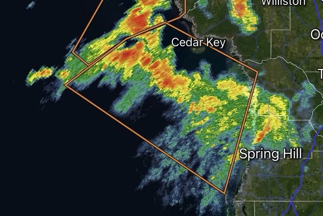
If you are navigating the waters along Florida’s West Coast, it is time to check your radar and secure your vessel. The National Weather Service (NWS) in Tampa Bay has issued an active Special Marine Warning targeting critical coastal and offshore zones, highlighting severe thunderstorms packing hazardous winds, heavy downpours, frequent lightning, and a dangerous potential for waterspouts.
Whether you are a commercial fisher heading out into deep federal waters or a recreational boater navigating inshore channels, understanding the scope of these sudden marine alerts is vital for your safety on the water.
Fast Facts: Special Marine Warning Event
Impacted Regions: Coastal waters from Tarpon Springs to the Suwannee River, FL (out 20 NM), as well as deeper waters from Tarpon Springs to the Suwannee River, FL (20 to 60 NM).
Core Hazards: Wind gusts in excess of 34 to 40 knots (39–46+ mph), locally higher choppy seas, frequent cloud-to-water lightning, torrential downpours reducing visibility, and the threat of rapidly forming waterspouts.
Issuing Agency: National Weather Service (NWS) Tampa Bay Area (Ruskin, FL).
Action Required: Seek safe harbor immediately, stay below deck, put on personal flotation devices, and monitor marine radio channels for continuous updates.
What Triggers a Special Marine Warning in the Gulf?
During the height of Florida’s convective summer season, high heat and humidity combine with active sea breezes to generate volatile thunderstorm cells. When these storms build rapidly over the warm waters of the Gulf of Mexico, they can transform calm cruising conditions into a life-threatening environment in a matter of minutes.
Unlike general small craft advisories, a Special Marine Warning is an urgent, short-term alert triggered when radar detects severe thunderstorms capable of producing sudden high-impact hazards:
1. Destructive Winds (34+ Knots): Rapidly shifting, high-velocity wind gusts can easily compromise small watercraft, snap rigging, and generate choppy, confused wave action.
2. Waterspout Development: Rotating updrafts beneath developing convective clouds can quickly spawn waterspouts over open water. These swirling columns can capsize boats without warning.
3. Zero Visibility Downpours: Torrential rain can blind operators, making navigation nearly impossible and increasing the risk of collisions or running aground.
Key Impacted Communities and Waterways
The current marine hazard zone blankets a major stretch of Florida’s Nature Coast and surrounding marine corridors. Communities and ports frequently affected by these advisories include:
Cedar Key
Crystal River
Yankeetown
Ozello and surrounding inshore creeks, flats, and offshore fishing grounds out to 60 nautical miles.
Mariners traversing these sectors should anticipate rapidly deteriorating conditions, sudden squalls, and abrupt wind shifts.
Marine Safety Checklist: How to Protect Yourself on the Water
When a Special Marine Warning is active, every second counts. Adhering to fundamental marine safety protocols can prevent a maritime tragedy:
Seek Safe Harbor Immediately: Do not attempt to outrun the storm. If you are near port, head directly to the nearest protected marina or boat ramp before conditions deteriorate. If you are far offshore, position your vessel to ride out the squall safely.
Watch for Waterspout Signs: Keep a sharp lookout for rotating columns descending from cloud bases, swirling water spray on the surface, or sudden erratic wind shifts. If a waterspout is spotted, navigate at a 90-degree angle away from its projected path.
Put on Personal Flotation Devices (PFDs): Ensure every individual on board is wearing a properly fitted life jacket. In rough seas and high winds, falling overboard can quickly become fatal.
Stay Below Deck and Secure Gear: If your boat has a cabin, move passengers inside and stay low. Lash down loose items on deck—including fishing rods, coolers, and canvas covers—to prevent them from becoming dangerous projectiles.
Monitor Marine Radio Channels: Keep your VHF-FM radio tuned to channels 16 or 22A, or enable emergency alerts on your mobile device to receive continuous radar updates and all-clear notifications from NWS Tampa Bay.
Stay Informed
Marine conditions on the Gulf Coast can shift from serene to treacherous in minutes. Always check real-time radar, monitor official marine forecasts from the National WeatherService, and respect local marine patrol guidance before casting off.
Stay safe, stay alert, and respect the power of the Gulf!
Radar Watch HQ Top 5 Marine Essentials
Affiliate Disclosure: As an Amazon Associate, Radar Watch HQ earns from qualifying purchases.
🌊 1. U.S. Coast Guard-Approved Life Jacket
A properly fitted life jacket is the most important piece of safety equipment for every passenger onboard.
Best for: Recreational boaters, anglers, kayakers, and paddleboarders.
⚓ 2. Marine Emergency Radio (NOAA Weather Radio)
Receive real-time NOAA Weather Radio alerts, marine forecasts, and emergency warnings—even when cell service is unavailable.
Best for: Offshore and coastal boating.
🔦 3. Rechargeable Waterproof LED Flashlight
A bright waterproof flashlight is essential for emergencies, low visibility, nighttime navigation, and signaling for help.
Best for: Every boat emergency kit.
🧰 4. Marine First Aid Kit
A waterproof first aid kit stocked with bandages, antiseptic, medications, and emergency supplies for injuries on the water.
Best for: Every vessel, regardless of size.
🧭 5. Waterproof Dry Bag
Protect phones, wallets, charts, keys, electronics, and emergency supplies from water damage during storms or rough seas.
Best for: Boaters, kayakers, paddleboarders, and beachgoers.
🛒 Radar Watch HQ Marine Safety Picks
Prepare before you head out on the water. Our recommended marine safety essentials can help keep you and your crew safe during changing weather conditions.