Fury of the Monsoon: Severe Thunderstorm Warnings Bring 1.50” Hail to Mora and San Miguel Counties, New Mexico
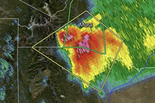
The rhythmic arrival of the North American monsoon typically brings life-giving moisture, vibrant greenery, and a welcome break from high desert heat across the Land of Enchantment. However, the exact same atmospheric dynamics that fuel seasonal relief can quickly turn volatile. The National Weather Service (NWS) in Albuquerque has issued urgent Severe Thunderstorm Warnings for Mora and San Miguel counties in New Mexico, highlighting a violent storm cell packing destructive winds, torrential rainfall, and large 1.50” hail (ping-pong ball size).
Whether you reside in Mora, Las Vegas (NM), Watrous, or surrounding mountain and high-plains corridors, understanding the severity of these rapid-onset convective storms is critical for protecting your family, vehicles, and property.
Fast Facts: Northern New Mexico Severe Weather Event
Impacted Regions: Mora County and San Miguel County, New Mexico (monitored by NWS Albuquerque).
Core Hazards: Large hail up to 1.50” in diameter (ping-pong ball size), damaging straight-line wind gusts up to 60 mph, frequent cloud-to-ground lightning, and heavy downpours.
Atmospheric Driver: Peak New Mexico monsoon season moisture colliding with daytime high-desert heating, creating high instability and robust updrafts.
Action Required: Seek immediate shelter in a sturdy permanent building, stay away from windows, and never attempt to cross flooded roadways.
The Monsoon Machine: Why New Mexico Storms Turn Severe Fast
New Mexico’s summer weather is heavily dictated by the monsoon season, a seasonal shift in wind patterns that pulls rich atmospheric moisture northward from the Gulf of California and the Gulf of Mexico. When this moisture-laden air interacts with rugged terrain—such as the Sangre de Cristo Mountains bordering Mora and San Miguel counties—it acts as an atmospheric trigger.
As the sun heats the high-desert terrain during the morning and early afternoon, thermal updrafts develop rapidly. Combined with atmospheric shear and ample moisture, these updrafts sustain powerful thunderstorm cells capable of producing enormous hailstones. Hailstones grow when intense upward air currents repeatedly push water droplets high into sub-freezing layers of the storm cloud, where they freeze and accumulate layers of ice before gravity finally pulls them to the earth. At 1.50” in diameter, these stones possess enough mass to shatter vehicle windshields, dent metal siding, and inflict severe damage on roof tiles and outdoor property.
Severe Thunderstorm Safety Checklist: How to Protect Your Family and Property
When a Severe Thunderstorm Warning flashes across your phone or weather radio, every minute counts. Follow these essential safety protocols:
Move Indoors Immediately: As the trusted meteorological saying goes, “When thunder roars, go indoors.” Seek shelter inside a sturdy, permanent building immediately. Mobile homes and open-sided structures do not offer adequate protection against severe winds and flying debris.
Stay Away from Windows: Large hail and high wind gusts create a severe glass-breakage hazard. Move to an interior room, hallway, or the lowest level of your home away from exterior windows and glass doors.
Protect Your Vehicle: If you are caught on the road or at home, move vehicles under a carport, garage, or heavy tree cover if time permits, but never risk your personal safety outdoors just to shield a car from hail.
Turn Around, Don’t Drown: Heavy monsoon downpours can dump inches of rain in a short span, overwhelming urban drains and rural arroyos. Never drive or walk through flooded roadways or low-water crossings. Just six inches of fast-moving water can sweep a vehicle off its wheels.
Prepare for Power Outages: High winds and lightning strikes frequently disrupt local electrical grids in northern New Mexico. Keep flashlights, extra batteries, fully charged mobile devices, and a battery-powered NOAA Weather Radio close at hand.
Stay Informed
Weather conditions during the New Mexico monsoon season can transform from calm, sunny skies to severe, life-threatening storm cells in a matter of minutes. Always keep your smartphone emergency alerts enabled, monitor local radar feeds closely, and heed all advisories issued by NWS Albuquerque.
Stay safe, stay alert, and respect the formidable power of the monsoon!

Affiliate Disclosure: As an Amazon Associate, Radar Watch HQ earns from qualifying purchases.
Radar Watch HQ Top 5 Essential Emergency Preparedness Picks
Whether you’re preparing for severe thunderstorms, flash flooding, hurricanes, wildfires, or extended power outages, these five emergency essentials can help keep your household safer when severe weather strikes.
A portable power station provides reliable backup electricity during outages, allowing you to power phones, medical devices, laptops, lights, small appliances, and communication equipment without fuel.
Best for:
- Extended power outages
- Severe thunderstorms
- Hurricanes
- Winter storms
- Wildfires
2. Flood Protection Barriers & Sandless Flood Bags
Flood barriers help divert or absorb water before it enters garages, doorways, and low-lying areas. They deploy quickly and can help reduce property damage during flash flooding.
Best for:
- Flash Flood Warnings
- Heavy rainfall
- River flooding
- Coastal flooding
3. Rechargeable LED Flashlights
Bright, dependable flashlights are essential when the power goes out. Rechargeable or solar-powered models provide long-lasting illumination for navigating safely indoors and outdoors.
Best for:
- Overnight power outages
- Emergency evacuations
- Storm damage inspections
Keep phones, tablets, weather radios, and USB-powered devices charged when the electrical grid is unavailable. A solar power bank offers an additional charging option during prolonged emergencies.
Best for:
- Communication during outages
- Emergency weather alerts
- Travel and evacuation
A NOAA Weather Radio delivers official weather alerts directly from the National Weather Service, even when cellular networks or internet service are unavailable. It remains one of the most dependable ways to receive life-saving warnings.
Best for:
- Tornado warnings
- Severe thunderstorm warnings
- Flash flood warnings
- Hurricane alerts
- Winter storm emergencies
Why Radar Watch HQ Recommends These Essentials
At Radar Watch HQ, preparedness is just as important as staying informed. These five emergency essentials can help you stay connected, protect your property, and safely navigate severe weather events. Having supplies ready before storms arrive allows you to respond quickly when warnings are issued and conditions begin to deteriorate.