
June 10, 2026 | Radar Watch HQ
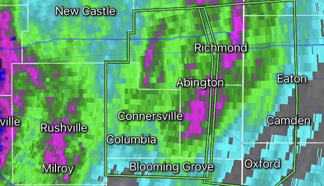
A confirmed tornado touched down in southern Iowa Wednesday as a powerful severe weather outbreak unfolded across portions of the Midwest. The tornado was reported near Moulton in Davis County, with additional storm damage reported in nearby communities as dangerous thunderstorms moved through the region.
The tornado developed within a highly volatile atmosphere fueled by warm temperatures, abundant moisture, and strong wind shear. Meteorologists had warned throughout the day that conditions were favorable for rotating supercell thunderstorms capable of producing tornadoes, destructive hail, and damaging straight-line winds.
Damage Reports Emerge
Early reports indicated structural damage in parts of southern Iowa, including areas near Garden Grove in Decatur County. Emergency officials continue assessing impacted locations as crews survey storm damage and determine the tornado’s strength and path.
Residents reported intense rainfall, powerful wind gusts, and frequent lightning accompanying the storms. Additional storm surveys are expected in the coming days to confirm the tornado’s rating and track length.
Dangerous Weather Setup
The severe weather event was driven by several atmospheric ingredients coming together across the Midwest:
- Warm, humid air flowing northward from the Gulf
- A strong upper-level disturbance moving across the Plains
- Significant wind shear supporting storm rotation
- High levels of atmospheric instability
These conditions created an environment favorable for supercell thunderstorms capable of producing tornadoes before evolving into larger clusters of severe storms.
More Than Just Tornadoes
While tornadoes posed the greatest threat, residents also faced:
- Large hail potentially exceeding 2 inches in diameter
- Damaging wind gusts above 70 mph
- Frequent cloud-to-ground lightning
- Heavy rainfall leading to localized flash flooding
Forecasters warned that severe weather could continue into the evening hours as storms moved eastward toward neighboring states.
Safety Remains Critical
Tornadoes can develop quickly and leave little time for preparation. Residents in severe weather-prone areas should ensure they have multiple ways to receive warnings and know where to seek shelter.
If a Tornado Warning is issued:
- Move immediately to the lowest level of a sturdy building.
- Stay away from windows and exterior walls.
- Protect your head and neck with blankets, pillows, or a helmet.
- Avoid mobile homes and vehicles whenever possible.
- Continue monitoring weather alerts until the threat has passed.
Looking Ahead
The severe weather pattern affecting Iowa is part of a larger system impacting much of the Midwest and Great Lakes region. Meteorologists continue monitoring the potential for additional tornadoes, damaging winds, and flash flooding as the storm system progresses eastward.
Radar Watch HQ will continue tracking developments, storm surveys, and updated damage assessments as more information becomes available from the National Weather Service and local emergency management officials.
Stay weather aware and follow all warnings issued by local authorities.