
Dangerous Storms Sweep Across the Midwest: Tornadoes, Damaging Winds, and Flooding Threats Continue
June 11, 2026
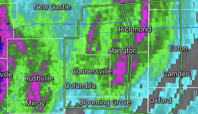
A powerful outbreak of severe weather is unfolding across the Midwest, bringing a dangerous combination of tornadoes, destructive straight-line winds, large hail, flash flooding, and widespread power outages. Millions of residents from the Plains to the Great Lakes remain under severe weather alerts as multiple rounds of thunderstorms continue to develop and move eastward. (The Weather Channel)
Meteorologists have identified a highly unstable atmosphere across the region, creating favorable conditions for supercell thunderstorms capable of producing tornadoes and intense wind damage. The greatest concerns include portions of Illinois, Iowa, Wisconsin, Missouri, Indiana, and surrounding states where severe thunderstorm and tornado warnings have been issued throughout the day. (The Weather Channel)
Widespread Wind Damage and Power Outages
One of the most significant impacts from this storm system has been damaging wind gusts exceeding 70 mph in some locations. These powerful winds have downed trees, damaged structures, and knocked out power to hundreds of thousands of customers across the Midwest. Utility crews are working around the clock to restore service as additional storms threaten already impacted areas. (FOX Weather)
Communities across Illinois, Wisconsin, and Missouri have reported extensive storm damage, including fallen power lines, damaged roofs, and blocked roadways. Travel disruptions have also been reported as severe weather affects major transportation corridors and airports. (FOX Weather)
Tornado Threat Remains Elevated
The Midwest remains one of the nation’s most active regions for tornado development during late spring and early summer. Tornadoes are commonly associated with rotating supercell thunderstorms, which can rapidly intensify when warm, moist air collides with cooler air masses. (NOAA National Severe Storms Laboratory)
Recent reports indicate multiple tornado sightings and damage assessments across several states. Emergency managers continue to urge residents to have multiple ways of receiving weather warnings and to seek shelter immediately when tornado warnings are issued. (AP News)
Flash Flooding Concerns Increase
In addition to severe winds and tornadoes, heavy rainfall is creating an increasing risk of flash flooding. Some storms are capable of producing rainfall rates exceeding two inches per hour, overwhelming drainage systems and causing rapid rises in creeks, streams, and urban roadways. (Good Morning America)
Drivers are reminded to never attempt to cross flooded roadways. Even a small amount of moving water can sweep vehicles off the road and create life-threatening situations.
Safety Tips During Severe Weather
- Monitor trusted weather sources and local alerts.
- Move indoors immediately when severe thunderstorms approach.
- Seek shelter in an interior room on the lowest floor during tornado warnings.
- Avoid windows and exterior walls.
- Keep emergency supplies, flashlights, and charged mobile devices ready.
- Never drive through flooded roadways.
- Stay away from downed power lines and damaged utility equipment.
Looking Ahead
Forecasters warn that the severe weather threat may continue through the next several days as an active weather pattern remains locked across the central and eastern United States. Additional rounds of thunderstorms could bring new tornadoes, damaging winds, large hail, and flooding concerns to communities already dealing with storm recovery efforts. (The Watchers)
Residents across the Midwest should remain weather-aware, monitor forecasts closely, and be prepared to act quickly if warnings are issued.
Radar Watch HQ will continue monitoring this developing severe weather situation and provide updates as conditions evolve.