Tropical Depression One Update: What You Need to Know
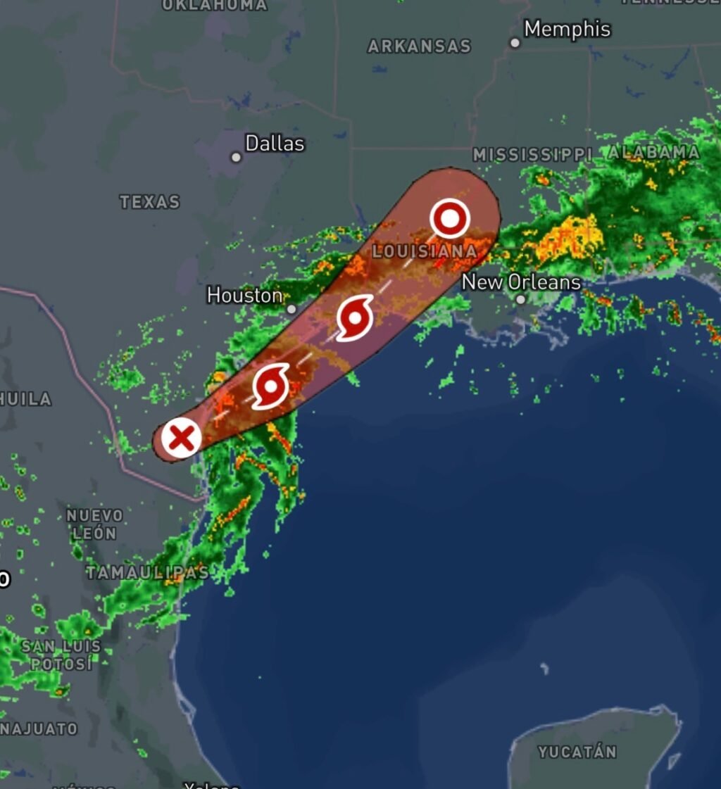
The 2026 Atlantic Hurricane Season has officially produced its first tropical cyclone. Tropical Depression One, currently designated by the National Hurricane Center as Potential Tropical Cyclone One, is developing in the western Gulf and could strengthen into Tropical Storm Arthur over the next 24 hours. (National Hurricane Center)
While wind impacts are expected to remain relatively modest, the primary concern with this system is heavy rainfall and dangerous flooding across portions of Texas, Louisiana, and the northwestern Gulf Coast. Forecasters are closely monitoring the storm as it moves northeastward at approximately 6 mph with sustained winds near 30 mph. (National Hurricane Center)
Current Storm Status
As of the latest advisory from the National Hurricane Center, Tropical Depression One is located near the South Texas coast and continues to organize over warm Gulf waters. Environmental conditions remain favorable enough for additional strengthening before the system moves inland. (National Hurricane Center)
Several forecast models suggest the system could briefly achieve tropical storm status, receiving the name Arthur, before making landfall. (WXII)
Greatest Threat: Flash Flooding
The most significant hazard associated with Tropical Depression One is excessive rainfall. Forecasts indicate widespread rainfall totals of 4 to 7 inches, with isolated locations potentially exceeding 10 inches. These amounts could trigger dangerous flash flooding, especially in urban areas and locations that have already received substantial rainfall recently. (Houston Chronicle)
Flood watches have been issued across portions of Southeast Texas, and residents are urged to remain alert for rapidly changing conditions. Forecasters warn that even areas outside the storm’s center may experience flooding due to persistent bands of heavy rain. (KPRC)
Coastal and Marine Impacts
Tropical storm watches have been issued for portions of the Texas Gulf Coast as forecasters anticipate strengthening winds and rough marine conditions. Coastal waters may experience elevated seas, dangerous rip currents, and hazardous boating conditions through midweek. (FOX 26 Houston)
Beachgoers and mariners should closely monitor local forecasts and heed any warnings issued by local emergency management officials.
What Happens Next?
Tropical Depression One is expected to continue tracking northeastward across the western Gulf before moving inland. Regardless of whether it reaches tropical storm strength, impacts from heavy rainfall, localized flooding, gusty winds, and rough surf are expected across portions of the Gulf Coast. (National Hurricane Center)
Meteorologists emphasize that early-season tropical systems often produce more flooding than wind damage, making rainfall the primary concern with this storm. Residents across Texas and neighboring Gulf Coast states should remain weather aware and monitor official forecasts from the National Hurricane Center and local National Weather Service offices. (National Hurricane Center)
Safety Tips
- Never drive through flooded roadways.
- Monitor local weather alerts frequently.
- Have multiple ways to receive emergency warnings.
- Secure outdoor items that may be blown around by gusty winds.
- Review your hurricane preparedness plan now, before peak hurricane season arrives.
As Tropical Depression One develops, Radar Watch HQ will continue providing updates, forecast information, and storm tracking coverage throughout the 2026 Atlantic Hurricane Season.