


Tropical Storm Warnings Issued: What You Need to Know and How to Prepare
As the 2026 Atlantic Hurricane Season continues, Tropical Storm Warnings are being issued for portions of the Gulf Coast as Tropical Storm Arthur develops and moves toward the Texas and Louisiana coastline. Residents in affected areas should take immediate precautions, as tropical storm conditions are expected within the warning area. (Houston Chronicle)
What Is a Tropical Storm Warning?
A Tropical Storm Warning means that tropical storm conditions are expected in a specified area, generally within the next 36 hours. These conditions can include:
- Sustained winds between 39 and 73 mph
- Heavy rainfall
- Flash flooding
- Coastal flooding
- Dangerous surf and rip currents
- Isolated tornadoes
A warning is different from a watch. A watch means tropical storm conditions are possible, while a warning means they are expected and preparations should be completed immediately. (Houston Chronicle)
Current Situation
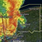
Tropical Storm Arthur has formed in the western Gulf of Mexico and is moving northeast toward the Texas and Louisiana coastlines. Tropical Storm Warnings are currently in effect from High Island, Texas, to Morgan City, Louisiana. Forecasters expect heavy rainfall, localized flooding, storm surge, and gusty winds as the system approaches landfall. (Houston Chronicle)
Rainfall totals of 4 to 8 inches are expected across parts of the Gulf Coast, with isolated locations receiving up to 12 inches. Life-threatening flash flooding remains one of the biggest concerns. (Beaumont Enterprise)
Main Threats From Tropical Storms
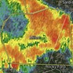
Heavy Rain and Flooding
Flooding is often the deadliest hazard associated with tropical systems. Slow-moving storms can dump large amounts of rainfall in a short period, overwhelming drainage systems and causing dangerous flash flooding. (Beaumont Enterprise)
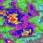
Strong Winds
Tropical storm-force winds can damage roofs, topple trees, and cause power outages. Loose outdoor items can become dangerous projectiles during strong wind events. (National Weather Service)
Storm Surge
Along the coast, storm surge can push seawater inland, flooding roads, homes, and businesses. Portions of the Texas and Louisiana coastline may experience water levels 2 to 4 feet above normally dry ground. (Beaumont Enterprise)
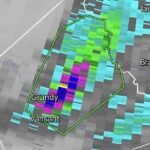
Tornadoes
Tropical systems frequently produce brief tornadoes, especially within outer rain bands. These tornadoes can develop quickly with little warning. (National Weather Service)
How to Prepare Now
1. Monitor Official Forecasts
Stay updated through the National Hurricane Center and your local National Weather Service office. Conditions can change rapidly as tropical systems approach land.
2. Charge Electronic Devices
Ensure cell phones, portable chargers, weather radios, and backup batteries are fully charged before the worst weather arrives.
3. Build an Emergency Kit
Include:
- Water for several days
- Non-perishable food
- Flashlights
- Batteries
- Medications
- Important documents
- First aid supplies
- Pet necessities
4. Secure Outdoor Items
Bring inside or secure:
- Patio furniture
- Trash cans
- Decorations
- Grills
- Outdoor equipment
5. Prepare for Power Outages
Have backup lighting and keep refrigerators and freezers closed as much as possible if power is lost.
6. Know Your Evacuation Zone
If you live in a flood-prone or coastal area, know evacuation routes and be prepared to leave if local officials issue evacuation orders.
7. Avoid Flooded Roads
Never drive through flooded roadways. Just a small amount of moving water can sweep vehicles away. Turn Around, Don’t Drown. (National Weather Service)
Final Thoughts
Tropical Storm Warnings are a signal to take action immediately. While Tropical Storm Arthur is not expected to become a major hurricane, flooding rain, gusty winds, coastal flooding, and isolated tornadoes can still create dangerous conditions across the Gulf Coast. Residents should use this time to finalize preparations, stay informed, and follow guidance from local emergency management officials. (Houston Chronicle)
Preparedness today can make a significant difference when severe weather arrives tomorrow.