Nebraska, Iowa, Missouri, and Kansas Weather Update: Severe Storms, Flooding Concerns, and Summer Heat Building Across the Plains
The central Plains and Midwest remain under an active weather pattern as Nebraska, Iowa, Missouri, and Kansas face multiple rounds of thunderstorms, heavy rainfall, flooding concerns, and the potential for severe weather heading into the weekend and early next week.
Meteorologists are closely monitoring a strengthening storm system that is expected to bring dangerous weather conditions across portions of the region. Residents should stay alert for changing forecasts and be prepared for severe thunderstorm warnings, flash flood warnings, and possible tornado watches.
Severe Thunderstorm Threat Expands Across the Region
Forecasters are highlighting Nebraska and Kansas as primary areas for severe thunderstorm development. Strong atmospheric instability, abundant moisture, and increasing wind shear will create favorable conditions for thunderstorms capable of producing:
- Large to very large hail
- Damaging wind gusts exceeding 75 mph
- Frequent lightning
- Isolated tornadoes
- Torrential rainfall
Storm Prediction Center outlooks indicate an enhanced risk for severe weather across portions of Kansas and Nebraska, with storms expected to develop during the afternoon and continue into the evening hours. (The Watchers)
As these storms move eastward, Iowa and Missouri could also experience severe weather, including strong winds, hail, and localized tornado potential. (ABC News)
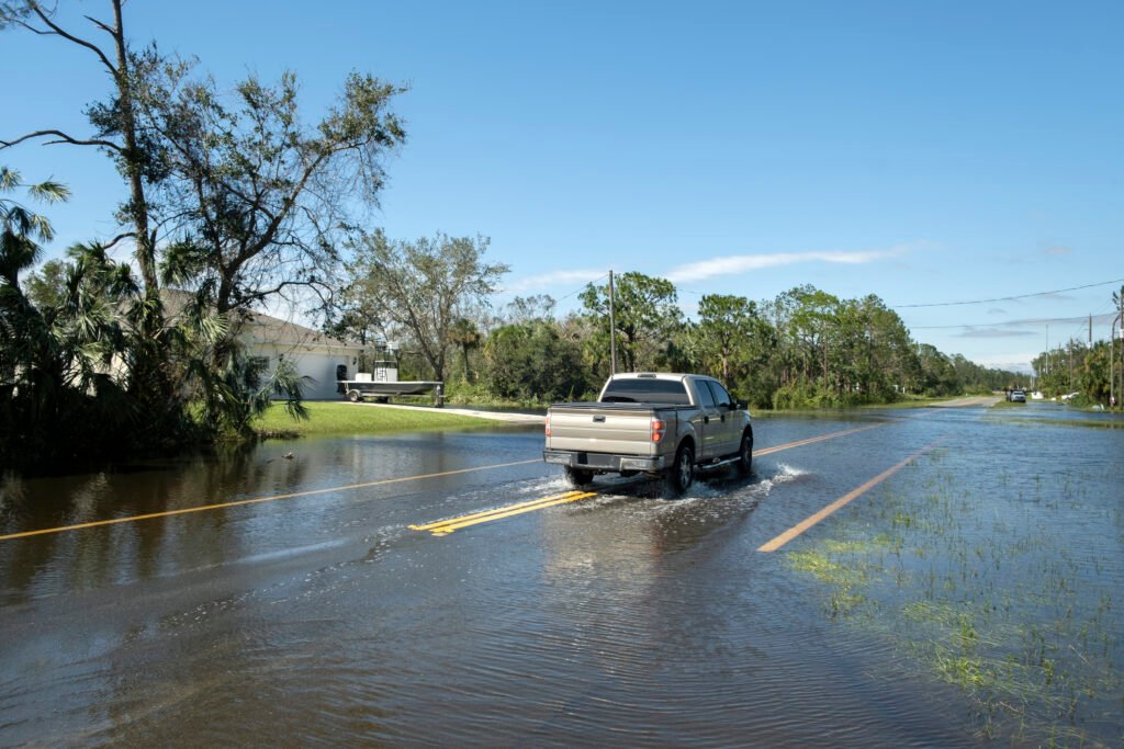
Flash Flooding Becoming a Growing Concern
One of the biggest concerns with this weather pattern is the potential for excessive rainfall and flash flooding.
Forecast models indicate widespread rainfall totals of 2 to 3 inches across parts of Nebraska, Iowa, Kansas, and Missouri, with isolated areas potentially receiving much higher amounts where thunderstorms repeatedly track over the same locations. (FOX Weather)
Training thunderstorms, where multiple storms move over the same area, can quickly overwhelm drainage systems, flood low-lying roads, and cause rapid rises on creeks and streams.
Areas that have already experienced recent rainfall will be especially vulnerable to flooding. Local emergency managers are encouraging residents to avoid driving through flooded roadways and remain weather aware during overnight hours when flash flooding can develop rapidly.
Recent Severe Weather Highlights
The region has already experienced a very active severe weather season in 2026.
Eastern Nebraska and western Iowa have seen multiple rounds of severe thunderstorms this spring, producing tornadoes, damaging winds, and flooding rainfall. The National Weather Service documented numerous warnings during major weather outbreaks in recent weeks. (National Weather Service)
Missouri has also dealt with significant flooding events and severe storms, while Kansas has experienced destructive wind events and intense thunderstorm outbreaks throughout June. (Ryan Hall, Y’all)
These repeated weather systems have left some communities vulnerable to additional impacts as new storms develop.
Heat and Humidity Fueling Storm Development
Another factor contributing to the severe weather threat is increasing moisture and humidity across the Plains.
Southerly winds are transporting Gulf moisture northward, causing dew points to rise into the 60s and 70s. This creates an unstable atmosphere capable of supporting strong thunderstorm development. (FOX Weather)
The combination of warm temperatures, high humidity, and approaching weather systems will continue to provide fuel for severe storms through the coming days.
Residents may also notice uncomfortable heat indices, especially in areas that remain storm-free during the afternoon hours.
What Residents Should Do Now
Communities across Nebraska, Iowa, Missouri, and Kansas should take several precautions:
- Monitor local forecasts frequently.
- Enable Wireless Emergency Alerts on mobile devices.
- Have multiple ways to receive weather warnings overnight.
- Review tornado safety plans with family members.
- Never drive through flooded roadways.
- Secure outdoor furniture and loose objects before storms arrive.
- Charge phones and emergency devices in case of power outages.
Preparation is especially important during active severe weather patterns when conditions can change rapidly.
Looking Ahead
The active weather pattern is expected to continue across the central United States, with additional opportunities for thunderstorms, heavy rainfall, and severe weather through the next several days. Forecast confidence remains high that portions of Nebraska, Iowa, Missouri, and Kansas will continue to face weather hazards ranging from damaging winds and hail to flooding rainfall. (FOX Weather)
Residents throughout the region should remain weather aware and stay connected to trusted forecast sources as summer storm season remains in full swing across the Plains and Midwest.