


🌩️ Ohio Valley Weather Alert: Kentucky, Indiana & Ohio Impact Zone
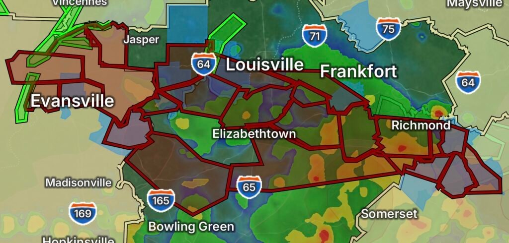
A developing weather system is bringing unstable conditions across the Ohio Valley, with heightened concern for parts of southern Indiana and central Kentucky, including Evansville, Indiana, Louisville, Kentucky, and Frankfort, Kentucky. This setup continues to support heavy rain, thunderstorms, and localized flooding risks as moisture streams into the region along a stalled boundary.
Recent atmospheric trends show a moisture-rich air mass building across the Lower Ohio Valley, increasing the potential for periods of heavy rainfall and embedded thunderstorms through the short term .
📍 Areas Under Attention
🇺🇸 Indiana
- Evansville and surrounding Vanderburgh County
- Southwestern and south-central Indiana river counties
- Localized low-lying flood-prone zones
🇺🇸 Kentucky
- Louisville metro area
- Frankfort and surrounding Franklin County
- Central Kentucky corridor along the Kentucky River basin
🌧️ Ohio Valley Region (broader impact)
- Southern Indiana → Central Kentucky → Northern Kentucky
- Nearby Ohio River communities with flood sensitivity
⚠️ Main Weather Hazards
🌧️ 1. Heavy Rainfall & Flash Flooding
Slow-moving systems and repeated storm development may lead to:
- 1–3 inches of rain possible in localized areas
- Ponding on roadways and urban flooding
- Rising creeks and river responses in low-lying areas
⛈️ 2. Thunderstorms
Storms may develop in clusters or lines, bringing:
- Brief heavy downpours
- Frequent lightning
- Gusty, localized wind bursts
🌪️ 3. Isolated Severe Threat (Lower Probability)
While not widespread, stronger storms could produce:
- Damaging wind gusts
- Small hail
- Brief spin-up rotation along boundaries
🌊 River & Flood Concerns
With saturated ground conditions in parts of the Ohio Valley:
- Rapid runoff is possible during heavy rain bursts
- Urban areas like Louisville are more vulnerable to street flooding
- Smaller tributaries near Frankfort may respond quickly to rainfall
📊 What This Pattern Means
The Ohio Valley is sitting near a moisture convergence zone, where warm Gulf air collides with incoming disturbances. This pattern often supports:
- Repeated storm redevelopment
- Training rainfall bands
- Quick changes in localized conditions over short distances
🧭 Preparedness Tips
- Avoid driving through flooded roadways (“Turn around, don’t drown”)
- Keep devices charged in case of power interruptions
- Monitor local alerts for rapid updates
- Secure outdoor items before storms arrive
- Be alert for sudden downpours, especially in low-visibility conditions
📌 Bottom Line
The Kentucky–Indiana–Ohio Valley corridor remains in a wet and storm-active pattern, with the main concern centered on heavy rainfall and isolated flooding impacts rather than widespread severe weather. However, conditions can change quickly, especially where storm clusters repeatedly track over the same areas.