


Springfield, Missouri Under Multiple Weather Alerts as Heavy Rain Brings Flash Flood Threat
Residents across Springfield, Missouri, and much of southwest Missouri are facing a dangerous round of severe weather as repeated thunderstorms move across the region. The combination of slow-moving storms, saturated ground, and intense rainfall has prompted Flash Flood Warnings, a Flood Watch, and a Hazardous Weather Outlook from the National Weather Service.
Meteorologists warn that multiple rounds of storms are capable of producing 1 to 3 inches of rain per hour, with localized totals significantly higher. Some communities have already experienced flooded roads, water rescues, and rapidly rising creeks and streams.
Flash Flood Warnings Issued
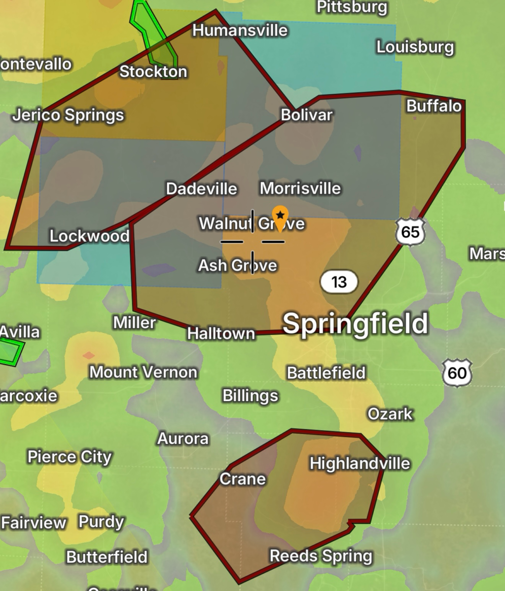
Flash Flood Warnings have been issued for portions of southwest Missouri, including areas surrounding Springfield. Emergency managers have reported flash flooding in communities including Ash Grove and Ebenezer, where rising water has forced road closures and water rescues.
Flooding impacts include:
- Water-covered roads
- Overflowing creeks and streams
- Flooded intersections
- Dangerous low-water crossings
- Rapid rises on rivers
Officials continue to remind motorists:
Turn Around, Don’t Drown. Just a small amount of moving water can sweep away a vehicle.
Flood Watch Remains in Effect
A Flood Watch remains in effect for much of the Springfield forecast area through Friday morning as additional rounds of heavy rainfall are expected.
Forecasters expect:
- Widespread rainfall totals of 1–2 inches
- Localized amounts approaching 5 inches
- Increased flash flooding risk
- Rising rivers and streams
- Flooding in urban and low-lying areas
The greatest concern is where storms repeatedly track over the same locations.
Hazardous Weather Outlook
The National Weather Service Hazardous Weather Outlook highlights several threats across southwest Missouri:
- Damaging wind gusts up to 60 mph
- Quarter-size hail
- Frequent cloud-to-ground lightning
- Heavy rainfall
- Localized flash flooding
- Isolated tornado potential, especially west of Interstate 49
Even areas that avoid severe winds may experience dangerous flooding from prolonged rainfall.
Power Outages Possible
Strong thunderstorms producing damaging winds and frequent lightning may result in scattered power outages throughout the Springfield metropolitan area and surrounding counties.
Residents should prepare by:
- Charging mobile devices
- Keeping flashlights ready
- Having backup batteries available
- Avoiding downed power lines
- Reporting outages to local utility providers
Localized outages may continue as additional storms develop overnight.
Safety Tips
If you live in or near Springfield:
- Never drive across flooded roadways.
- Monitor local weather alerts frequently.
- Have multiple ways to receive emergency warnings overnight.
- Move to higher ground if flooding develops.
- Delay unnecessary travel during periods of heavy rainfall.
- Stay indoors during severe thunderstorms.
Forecast Outlook
Additional thunderstorms are expected through Friday before conditions gradually improve. While rainfall should decrease later in the week, rivers and streams may continue rising after the heaviest rain ends. Areas receiving repeated storms will remain vulnerable to flash flooding.
Residents across Springfield and southwest Missouri should remain weather aware until all watches and warnings have expired.