


Tornado Watches, Flood Warnings, and Tropical Storm Arthur: A Dangerous Weather Pattern Across the United States
As communities across the United States continue to deal with severe weather, millions of Americans are facing a combination of tornado watches, flash flood warnings, river flooding, and widespread power outages. While Tropical Storm Arthur has weakened from its tropical classification, its impacts continue to be felt across much of the South and Southeast through dangerous flooding rains, severe thunderstorms, and an increased tornado threat. (The Guardian)
How Tropical Storm Arthur Is Fueling Severe Weather
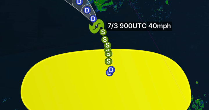
Tropical Storm Arthur became the first named storm of the 2026 Atlantic Hurricane Season after developing near the Texas coast. Although the storm weakened after landfall, its moisture-rich circulation continues to pump enormous amounts of tropical moisture into the Gulf Coast and southeastern United States. (FOX Weather)
This tropical moisture is interacting with existing weather systems, creating ideal conditions for:
- Torrential rainfall
- Flash flooding
- River flooding
- Severe thunderstorms
- Tornado development
- Damaging straight-line winds
- Dangerous lightning
Forecasters have reported rainfall totals exceeding several inches in many locations, with isolated areas potentially receiving more than a foot of rain. Some locations along the Gulf Coast have faced rainfall rates approaching 3 inches per hour. (Houston Chronicle)
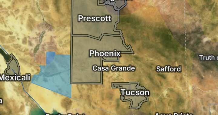
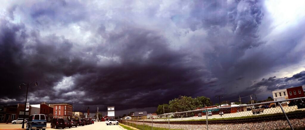
Tornado Watches Issued Across Multiple States
The same atmospheric ingredients fueling heavy rainfall are also increasing the risk for tornadoes.
Tornado watches and severe thunderstorm watches have been issued across portions of:
- Louisiana
- Mississippi
- Alabama
- Georgia
- Florida Panhandle
- Illinois
- Indiana
- Kentucky
- Connecticut
- Parts of the Northeast
Meteorologists warn that tropical systems often create fast-moving, short-lived tornadoes that can develop quickly with little warning. These tornadoes may not be as large as Great Plains tornadoes but can still cause significant damage to homes, businesses, and infrastructure. (WWLTV)
Flash Flooding Becoming the Biggest Threat
While tornadoes receive much of the attention, flooding is proving to be the most widespread and dangerous hazard from Arthur.
Flood watches remain in effect across large portions of the Gulf Coast and Southeast as creeks, streams, rivers, and drainage systems become overwhelmed by excessive rainfall. Emergency managers are particularly concerned about:
- Rapid rises on small streams
- Urban flooding
- Flooded roadways
- River flooding
- Water rescues
- Infrastructure damage
Floodwaters can rise quickly during tropical rainfall events, especially when multiple rounds of thunderstorms move over the same area. (New York Post)
Power Outages Continue to Increase
Strong winds, saturated soil, and falling trees have led to widespread power outages across multiple states.
Utility crews are working around the clock to restore service, but additional severe weather could slow recovery efforts. Heavy rain combined with gusty winds increases the likelihood of:
- Downed power lines
- Damaged utility poles
- Tree damage
- Road closures
- Communication disruptions
Many communities across the Midwest, Gulf Coast, and Northeast have reported thousands of customers without electricity following severe thunderstorms and tornado-producing storms. (Times Union)
What Residents Need To Do Right Now
During a Tornado Watch
A tornado watch means conditions are favorable for tornado development.
Residents should:
- Review emergency plans.
- Keep mobile devices charged.
- Monitor NOAA Weather Radio and local alerts.
- Identify a safe shelter location.
- Be prepared to move quickly if a warning is issued.
During a Tornado Warning
A tornado warning means a tornado is occurring or imminent.
Immediately:
- Move to the lowest level of a sturdy building.
- Stay away from windows.
- Protect your head and neck.
- Avoid mobile homes whenever possible.
- Do not attempt to outrun a tornado in heavy traffic.
During Flash Flooding
Remember the phrase:
Turn Around, Don’t Drown.
Never drive through flooded roadways.
Just a few inches of moving water can sweep away a vehicle. Floodwaters may also conceal:
- Washed-out roads
- Debris
- Sinkholes
- Downed power lines
If You Lose Power
- Use flashlights instead of candles.
- Keep refrigerators closed as much as possible.
- Charge essential devices.
- Have extra batteries available.
- Check on elderly neighbors and vulnerable family members.
Looking Ahead
Although Tropical Storm Arthur has weakened, its remnants continue to produce dangerous weather conditions across a large portion of the United States. Flooding concerns may persist for days after the heaviest rain ends as rivers and streams continue to rise downstream. Additional rounds of severe thunderstorms and isolated tornadoes remain possible across parts of the South, Southeast, and East Coast as Arthur’s moisture spreads inland. (Houston Chronicle)
Residents are encouraged to remain weather aware, monitor forecasts frequently, and take all watches and warnings seriously. Conditions can change rapidly, especially during tropical weather events where flooding and tornadoes may develop with little notice.
At Radar Watch HQ, we will continue monitoring Tropical Storm Arthur, tornado watches, flood warnings, river forecasts, and severe weather threats impacting communities across the nation.