Two EF-3 Tornadoes Reported as Severe Storms Tear Across the Midwest
Powerful Storm System Leaves Trail of Destruction
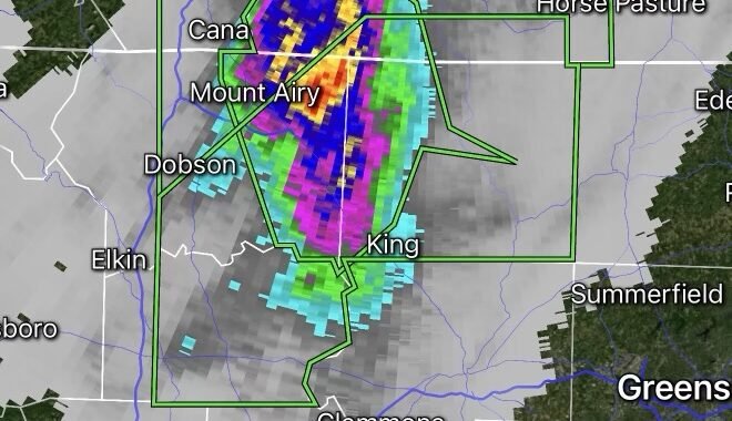
A dangerous severe weather outbreak swept across portions of the Midwest this week, producing at least two confirmed EF-3 tornadoes and causing widespread damage across multiple communities. The storms brought destructive winds, large hail, torrential rainfall, and numerous tornado reports as they tracked through Illinois, Indiana, and surrounding states. Preliminary storm surveys indicate that some tornadoes reached EF-3 intensity, capable of producing wind speeds between 136 and 165 mph. (The Watchers)
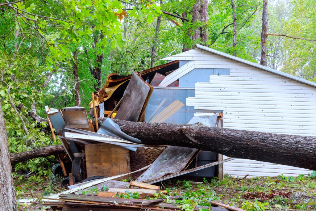
One of the strongest tornadoes impacted central Illinois near Washburn, where survey teams documented significant structural damage, uprooted trees, and destroyed outbuildings. The tornado carved a wide path through rural areas and was classified as an EF-3 after damage assessments were completed. Officials reported that several additional tornadoes were also observed during the outbreak. (The Watchers)
Hundreds of Storm Reports Across the Region
The severe weather event generated hundreds of reports of damaging winds, hail, and tornadoes across the Midwest. Communities from Iowa and Wisconsin to Illinois and Indiana experienced dangerous conditions as powerful thunderstorms rapidly intensified along a strong weather front. Forecasters had warned of the potential for strong, long-track tornadoes and widespread damaging winds before the storms developed. (FOX Weather)
In some locations, residents described the aftermath as resembling a disaster zone, with homes damaged or destroyed, roads blocked by fallen trees, and widespread power outages. Emergency crews worked throughout the night responding to damage reports and assisting affected residents. (People.com)
Power Outages and Recovery Efforts Continue
Utility crews continue working to restore power to thousands of customers impacted by the storms. Fallen trees and downed power lines contributed to significant outages across parts of Illinois and Indiana. Local emergency management agencies are conducting damage assessments while cleanup operations remain underway. (People.com)
More Severe Weather Possible
Meteorologists warn that the active weather pattern is not over. Additional rounds of thunderstorms remain possible across parts of the Midwest and Great Lakes region, with damaging winds, large hail, and isolated tornadoes remaining concerns in the coming days. Residents are encouraged to monitor forecasts closely and have multiple ways to receive weather warnings. (The Telegraph)
Safety Reminder
When a Tornado Warning is issued:
- Move immediately to a basement or interior room on the lowest floor.
- Stay away from windows and exterior walls.
- Protect your head and neck with a mattress, blanket, or helmet.
- Keep a weather radio, mobile alerts, or trusted weather source available.
- Never attempt to outrun a tornado in heavy traffic.
As storm surveys continue, additional tornado ratings and damage reports may be released by National Weather Service offices throughout the affected region.
Radar Watch HQ will continue monitoring this developing severe weather situation and provide updates as new information becomes available.