Flood Watch Issued for Southeast Michigan as Widespread Rainfall Threatens Flooding
Flood Watch in Effect Across Portions of Southeast Michigan
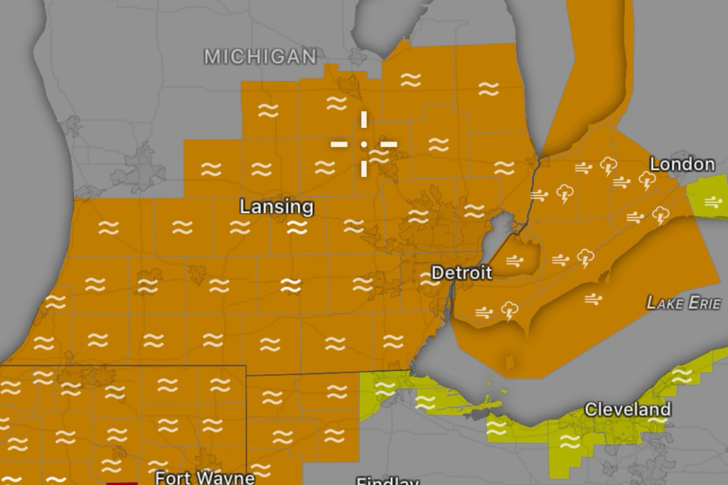
Residents across portions of Southeast Michigan are being urged to stay weather aware as a Flood Watch remains in effect due to the threat of widespread heavy rainfall and potential flooding. Multiple rounds of showers and thunderstorms are expected to move across the region, increasing the risk for flash flooding, especially in low-lying and poor-drainage areas. (WDIV)
The National Weather Service indicates that widespread rainfall totals of 1 to 2 inches are likely, with localized areas potentially receiving 3 inches or more where thunderstorms repeatedly move over the same locations. Saturated ground conditions and urban development may increase runoff concerns and lead to rapid rises in creeks, streams, and drainage systems. (The Sun Times News)
Counties Impacted
The Flood Watch includes several counties across Southeast Michigan, including portions of the Detroit metropolitan area and surrounding communities. Areas under the watch include:
- Wayne County
- Oakland County
- Macomb County
- Washtenaw County
- Livingston County
- Monroe County
- St. Clair County
- Lapeer County
Additional counties may experience localized flooding concerns as rainfall spreads across the region. (The Sun Times News)
Main Weather Threats
Flash Flooding
Heavy downpours could overwhelm storm drains and create dangerous roadway flooding, especially during the evening and overnight hours. Urban locations face the highest risk for rapid flooding. (FOX 2 Detroit)
Ponding on Roads
Motorists should expect reduced visibility and standing water on roads during periods of heavy rainfall. Travel conditions may deteriorate quickly as storms develop.
River and Stream Rises
Excessive runoff may cause rivers, creeks, and streams to rise, potentially impacting flood-prone communities. (National Weather Service)
Isolated Severe Storms
In addition to flooding concerns, some thunderstorms may produce strong wind gusts, frequent lightning, and isolated severe weather. (WDIV)
Safety Tips During Flooding
- Never drive through flooded roadways.
- Turn around if you encounter water covering the road.
- Monitor local weather alerts and emergency notifications.
- Have multiple ways to receive weather warnings overnight.
- Move valuable items away from basements or flood-prone areas.
- Avoid walking through floodwaters, as hidden hazards may exist.
Looking Ahead
The heaviest rainfall is expected through Wednesday evening and overnight before conditions gradually improve on Thursday. However, localized flooding may continue even after the rain ends due to runoff and swollen waterways. Residents across Southeast Michigan should remain alert for possible Flood Warnings that may be issued if flooding develops. (WDIV)
Stay with Radar Watch HQ for the latest weather alerts, radar updates, and flood safety information as this event unfolds.