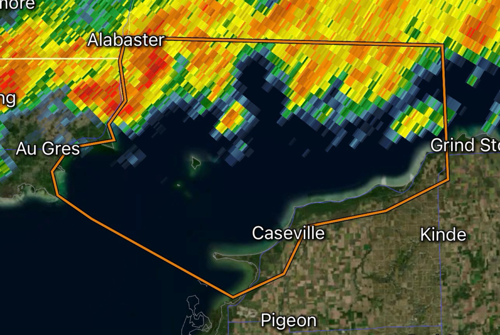
A Special Marine Warning has been issued for Outer Saginaw Bay southwest of Alabaster to Port Austin, Michigan, extending into Inner Saginaw Bay, as strong thunderstorms move across the region capable of producing wind gusts up to 34 knots (approximately 39 mph). These storms can create rapidly changing and dangerous conditions for anyone on the water. (National Weather Service)
Although thunderstorms over land can be hazardous, storms over open water often become even more dangerous due to the lack of shelter and the ability for strong winds to generate steep, choppy waves in a matter of minutes.
Marine Hazards Expected
Mariners throughout the warning area should prepare for:
- Wind gusts up to 34 knots
- Frequent lightning
- Heavy rainfall reducing visibility
- Sudden rough waves
- Dangerous conditions for small boats and personal watercraft
Strong thunderstorm outflow winds can arrive well ahead of the rain, catching boaters off guard if they are not monitoring weather conditions. (National Weather Service)
Areas Impacted
The warning includes marine waters across:
- Outer Saginaw Bay southwest of Alabaster
- Port Austin
- Inner Saginaw Bay
- Portions of southern Lake Huron
These waters are popular with recreational boaters, anglers, sailors, and paddlers during the summer season. Even experienced mariners should exercise caution when thunderstorms are nearby.
What Boaters Should Do Immediately
If you are currently on Lake Huron or Saginaw Bay:
- Head to the nearest safe harbor immediately.
- Do not attempt to outrun approaching thunderstorms.
- Secure loose equipment before winds increase.
- Monitor NOAA Weather Radio or trusted weather sources for updated warnings.
- Stay off open water until storms have completely passed.
Lightning can strike several miles away from the heaviest rainfall, making it unsafe to remain on exposed decks even before the storm arrives.
Why 34-Knot Winds Matter
A wind speed of 34 knots marks the threshold where thunderstorms begin producing conditions capable of causing significant hazards for recreational vessels. Wind-driven waves can build quickly across Saginaw Bay, making navigation difficult and increasing the risk of capsizing smaller boats.
Combined with lightning and reduced visibility from heavy rain, these storms create life-threatening conditions that require immediate action.
Conditions Improve After the Storm
Forecast conditions indicate thunderstorms will move out of the area later, with lighter northeast winds and calmer wave conditions expected afterward as high pressure builds into the Great Lakes. Mariners should still verify the latest marine forecast before returning to the water. (National Data Buoy Center)
Stay Weather Aware with Radar Watch HQ
Radar Watch HQ continues to monitor severe weather and marine alerts across the Great Lakes and the United States. Follow us for real-time warning updates, radar analysis, severe weather preparedness tips, and boating safety information to help keep you and your family safe during rapidly changing weather.
Affiliate Disclosure: As an Amazon Associate, Radar Watch HQ earns from qualifying purchases.
Radar Watch HQ Top 5 Marine Safety Essentials
Planning to be on the water? These five essentials can help you stay prepared when severe weather develops unexpectedly.
1. U.S. Coast Guard-Approved Life Jacket – Every passenger should have a properly fitted life jacket that’s readily accessible.
2. Waterproof Marine Emergency Radio – Stay connected to NOAA Weather Radio and receive Special Marine Warnings even when cell service is unavailable.
3. Waterproof Dry Bag – Protect your phone, wallet, keys, medications, and emergency supplies from heavy rain and waves.
4. High-Powered Waterproof Flashlight – Essential for navigating in low visibility, nighttime conditions, or emergency situations.
5. Marine First Aid Kit – A well-stocked waterproof first aid kit can make a critical difference while waiting for assistance.