Widespread Flood Threat Develops Across the Upper Midwest
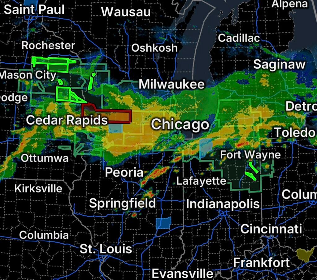
A broad area of the Upper Midwest and Great Lakes is facing an elevated flooding threat on Saturday, September 19, as heavy rainfall affects communities from southeastern Minnesota and northeastern Iowa into Wisconsin, Illinois, Indiana, Michigan and Ohio.
The National Weather Service has issued a combination of Flood Warnings, Flash Flood Warnings and Flood Watches, reflecting both ongoing flooding and the potential for additional excessive rainfall.
Residents in affected areas should monitor updated forecasts and be prepared to act quickly if water begins rising.
Flood Warning — Southern Fillmore County, Minnesota
A Flash Flood Warning is in effect for southern Fillmore County in southeastern Minnesota following thunderstorms that produced significant rainfall.
The National Weather Service reported that radar and automated rain gauges indicated 3 to 5 inches of rainfall, with additional rainfall possible. Flash flooding is affecting or threatening small creeks and streams, urban areas, highways, streets, underpasses and other low-lying locations.
Communities and locations in the broader warned area include:
- Preston
- Spring Valley
- Harmony
- Mabel
- Canton
- Highland
- Cherry Grove
- Bristol
- Newburg
- York
- Carimona
- Ostrander
- Hutton
- Granger
- Forestville State Park
- Greenleafton
- Henrytown
With soils and drainage systems already stressed by heavy rainfall, additional storms could quickly worsen flooding.
Flood Watch — Iowa, Southeast Minnesota and Southwest Wisconsin
A Flood Watch covers portions of Iowa, southeast Minnesota and southwest Wisconsin as excessive rainfall continues to pose a flooding threat.
The National Weather Service has highlighted the possibility of flooding involving rivers, creeks, streams, urban areas and locations with poor drainage.
Areas included in the broader watch include portions of:
Iowa: Allamakee, Chickasaw, Clayton, Fayette, Floyd, Howard, Mitchell and Winneshiek counties.
Minnesota: Dodge, Fillmore, Houston, Mower, Olmsted, Wabasha and Winona counties among the affected southeastern areas.
Wisconsin: Crawford, Grant, La Crosse, Monroe, Richland and Vernon counties, with additional areas included in regional flood watches.
Flash Flood Warning — Northeast Iowa and Northwest Illinois Communities
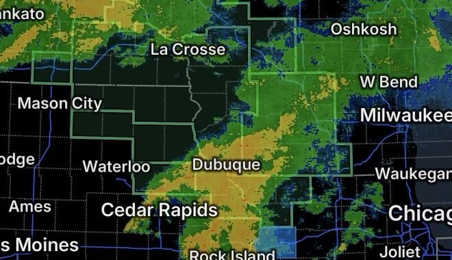
A significant flash-flood threat also extends across portions of northeast Iowa and northwest Illinois.
Communities specifically identified in the warning area include:
Iowa and Illinois communities: Dubuque, Freeport, Galena, Asbury, Dyersville, Lena, Bellevue, Cascade, Stockton, Epworth, East Dubuque, Farley, Warren, Peosta, Hanover, Pearl City, Elizabeth, Cedarville, Davis and Woodbine.
A Flood Watch also covers portions of northwest Illinois, including areas around Dubuque, Jackson, Jo Daviess, Stephenson and Carroll counties. The National Weather Service warns that excessive rainfall could produce both flooding and flash flooding.
Residents should pay particular attention to rapidly rising water on roads, in low-lying areas and near creeks and streams.
Flood Watch Expands Into Indiana, Michigan and Ohio
The flooding concern extends eastward, with a Flood Watch covering portions of Indiana, southwest Michigan and northwest Ohio.
Additional rainfall could produce excessive runoff and aggravate flooding along waterways and in areas that have already received substantial precipitation.
This means flooding could develop even outside locations experiencing the heaviest rainfall directly, particularly where water is flowing downstream from areas that received intense precipitation.
Flood Warning — Wabash River Near Bluffton, Indiana
River flooding is already occurring along the Wabash River near Bluffton, Indiana, in Wells County.
The National Weather Service reported that the river was at 14.9 feet at 8:45 PM EDT Friday, with a flood stage of 10 feet. The maximum stage during the preceding 24 hours reached 15.5 feet. Moderate flooding was occurring and was forecast to continue before the river gradually falls below flood stage.
Flooding impacts include portions of northern Bluffton, low areas near the wastewater treatment plant, and portions of Elm Grove Road and County Road 450.
The warning is expected to remain in effect into next week as river levels slowly decline.
Why This Flood Threat Matters
This event involves several different types of flooding at the same time.
Flash flooding can develop rapidly when thunderstorms produce intense rainfall over a short period.
River flooding can persist for days because rivers continue receiving runoff after the heaviest rainfall has ended.
Urban flooding can occur when rainfall overwhelms storm drains and drainage systems.
Roadway flooding can become especially dangerous when water covers the pavement and hides the depth or condition of the road underneath.
The National Weather Service has emphasized that motorists should never attempt to drive through flooded roads.
Flood Safety: What Residents Should Do
If you are in an area under a Flood Warning or Flash Flood Warning:
- Move to higher ground if flooding threatens your location.
- Never drive through a flooded roadway.
- Turn around when encountering floodwater on a road.
- Do not bypass barricades or road closures.
- Stay away from flooded rivers, creeks and streams.
- Keep children and pets away from rapidly moving water.
- Be especially cautious overnight when flooding can be difficult to see.
- Monitor local emergency officials and National Weather Service updates.
- Be prepared for additional warnings if heavy rainfall continues.
Even shallow moving water can sweep away a vehicle, while deeper water can conceal washed-out roads, debris and other hazards.
Radar Watch HQ Final Thoughts
The flood threat across the Upper Midwest and Great Lakes region is not limited to a single community. From southern Fillmore County, Minnesota, through Iowa, Wisconsin and northwest Illinois, and eastward into Indiana, Michigan and Ohio, multiple flood hazards are being monitored.
Ongoing flash flooding in parts of Minnesota and the Mississippi River Valley region is occurring alongside longer-duration river flooding farther east. Additional rainfall could worsen existing conditions and create new flooding problems.
If a Flood Warning or Flash Flood Warning is issued for your location, take action immediately and move away from dangerous floodwater. Never risk driving through a flooded roadway.
Stay weather-aware, monitor official updates, and put safety first as this widespread flooding event continues.