Flood Watch Covers Multiple Areas Across the Upper Midwest
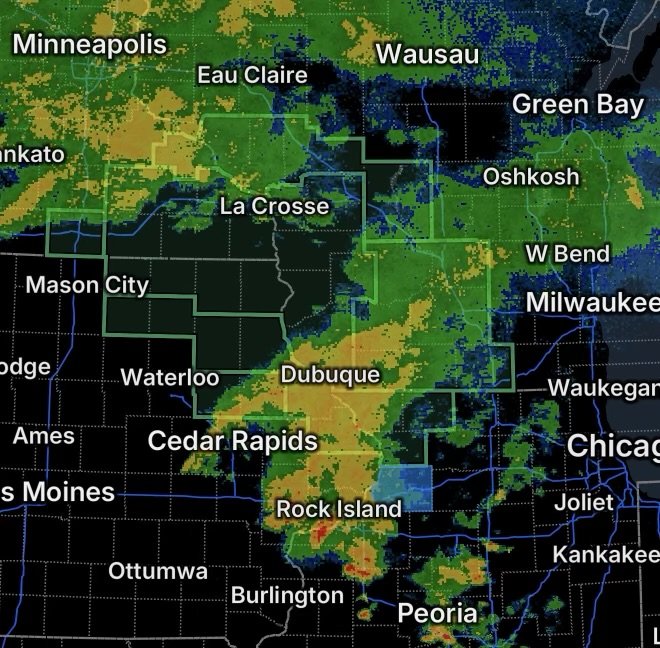
A widespread heavy-rain event is developing across portions of the Upper Midwest, prompting Flood Watches for areas of south central Wisconsin, Iowa, Freeborn County in southern Minnesota, and northwest Illinois.
The National Weather Service says repeated rounds of rain and thunderstorms could produce excessive runoff, causing rivers, creeks and streams to rise. Low-lying, flood-prone and poor-drainage areas may experience flooding as rainfall continues.
Residents in the affected areas should remain alert through the overnight period and into Saturday as additional rainfall develops.
South Central Wisconsin Flood Watch
A Flood Watch remains in effect for a portion of south central Wisconsin, including:
- Columbia County
- Dane County
- Green County
- Iowa County
- Lafayette County
- Rock County
- Sauk County
The watch is in effect from late tonight through Saturday afternoon.
The National Weather Service expects widespread and prolonged showers and thunderstorms, with rainfall totals generally around 1 to 3 inches. Areas that experience repeated thunderstorms could receive 3 to 5 inches or more, increasing the potential for flooding.
Urban areas, poor-drainage locations and areas near rivers, creeks and streams will need particular attention.
Flood Watch Continues Across Portions of Iowa
Flooding concerns also extend across portions of Iowa, where additional rounds of rain and thunderstorms are expected.
A Flood Watch covering Dubuque and Jackson Counties begins late tonight and continues through Saturday evening. The National Weather Service says widespread showers and thunderstorms could produce rainfall rates of 1 to 2 inches per hour, with totals of 1 to 3 inches and locally higher amounts possible.
The combination of heavy rainfall rates and repeated storms could result in rapid runoff and rising waterways.
Freeborn County, Minnesota
Freeborn County, including Albert Lea, remains under a Flood Watch from this evening through Saturday morning.
This area faces a particularly notable rainfall concern because the forecast includes two rounds of rain. Steady rain is expected during the day, followed by the potential for training thunderstorms this evening.
The National Weather Service indicates that repeated thunderstorms over the same location could create a flash-flood threat, with maximum rainfall totals of 5 to 7 inches possible.
Creeks and streams could rise out of their banks, while urban and poor-drainage locations could experience flooding.
Northwest Illinois Under Flood Watch
A Flood Watch also covers portions of northwest Illinois, including:
- Carroll County
- Jo Daviess County
- Stephenson County
The watch begins late tonight and continues through Saturday evening.
Heavy showers and thunderstorms could produce rainfall rates of 1 to 2 inches per hour. Rainfall totals of 1 to 3 inches are expected, with localized amounts exceeding 3 inches possible.
Communities around rivers, creeks and streams should be prepared for rising water, while urban areas may experience ponding and drainage-related flooding.
Why Repeated Thunderstorms Matter
The greatest flooding concerns may develop where thunderstorms repeatedly move across the same locations.
When storms continually pass over one area, rainfall can accumulate faster than the ground, storm drains and waterways can handle it. This can lead to rapid rises in creeks and streams and, in more vulnerable areas, flash flooding.
The National Weather Service is also monitoring additional rounds of rain and thunderstorms into Saturday and Sunday across parts of the region.
Flood Safety Reminders
Residents under a Flood Watch should monitor updated forecasts and be prepared for a Flood Warning if conditions worsen.
- Never drive through a flooded roadway.
- Turn around if you encounter water covering the road.
- Keep away from fast-moving water and swollen creeks.
- Move to higher ground if flooding begins near your location.
- Avoid low-lying areas that frequently flood.
- Have multiple ways to receive weather alerts, especially overnight.
- Remember that flooding can occur even where it is not currently raining if water is moving downstream.
A Flood Watch means conditions are favorable for flooding. It does not mean that flooding is occurring everywhere within the watch area, but residents should be prepared to act if warnings are issued.
Radar Watch HQ Final Thoughts
The combination of widespread rainfall, thunderstorms and the potential for repeated heavy downpours makes this an important period for flood awareness across parts of Wisconsin, Iowa, Minnesota and northwest Illinois.
Stay weather-aware through tonight and Saturday, especially near rivers, creeks, streams and locations with a history of flooding. Continue monitoring official National Weather Service updates as the rainfall pattern develops.
Stay alert, stay informed, and never risk driving through floodwater.