Flood and Severe Weather Threats Expand Across the Ohio Valley and Appalachians
September 21, 2026, brings a combination of flooding, heavy rainfall and thunderstorms across portions of Ohio, West Virginia and southwest Virginia. The National Weather Service is highlighting areas where additional rainfall could worsen ongoing flooding, while thunderstorms may produce locally heavy rain and strong winds.
The National Weather Service reports that heavy rain and localized flash flooding remain possible across northern West Virginia and southeast Ohio, with additional downpours and isolated strong thunderstorms possible later.
Flood Watch: Eastern and Southeastern Ohio
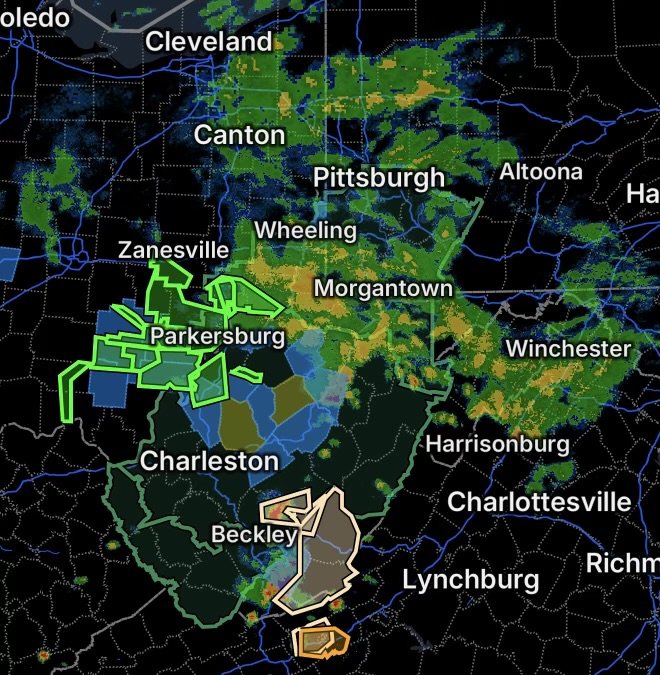
A Flood Watch covers portions of east central Ohio and southeast Ohio, including areas where excessive rainfall could lead to flooding of rivers, creeks, streams and low-lying locations.
The east-central Ohio watch includes areas such as Belmont, Carroll, Columbiana, Coshocton, Guernsey, Harrison, Jefferson, Monroe, Muskingum, Noble and Tuscarawas counties. The National Weather Service notes that additional rainfall combined with saturated ground can increase the potential for flash flooding.
Portions of southeastern Ohio are also under a Flood Watch, including Athens, Gallia, Jackson, Lawrence, Meigs, Morgan, Perry, Vinton and Washington counties.
Residents in these areas should remain alert for rapidly rising water, especially near small streams, creeks and drainage areas.
Flood Watch: Southern West Virginia
A broad Flood Watch also affects portions of southeast, southern and western West Virginia.
In southern West Virginia, the watch includes:
- Logan County
- McDowell County
- Mingo County
- Wyoming County
Additional portions of West Virginia are also included in the broader flood threat area. The combination of repeated rainfall and already wet ground can allow water to accumulate quickly in flood-prone locations.
Why the Flood Risk Matters
Flooding does not require widespread rainfall totals to become dangerous. Heavy thunderstorms can produce intense rainfall over a small area in a short period of time. When the ground is already saturated, runoff can move rapidly into creeks, streams and low-lying roads.
The National Weather Service advises residents to monitor later forecasts and be prepared to act if Flood Warnings or Flash Flood Warnings are issued.
Flood Warning: Southeastern Ohio
A Flood Warning is in effect for portions of southeastern Ohio, including:
- Central Athens County
- Southwestern Morgan County
- Northeastern Vinton County
- West-central Washington County
The National Weather Service states that the warning is due to flooding caused by excessive rainfall.
A separate flood warning also includes portions of Athens, Gallia, Meigs and Washington counties in southeastern Ohio.
Because these areas are already experiencing flooding, residents should treat flooded roads and rapidly rising waterways as immediate hazards rather than waiting for conditions to improve.
Special Weather Statement: Southwest Virginia and Southern West Virginia
A Special Weather Statement covers:
- Northeastern Giles County
- Greenbrier County
- Eastern Summers County
- East-central Mercer County
- Monroe County
Thunderstorms and locally heavy rainfall remain possible across the region. The broader NWS outlook calls for isolated severe wind gusts this afternoon, along with locally heavy rainfall capable of producing isolated flooding.
Severe Thunderstorm Warning: Southwest Virginia
A Severe Thunderstorm Warning affects:
- Northeastern Pulaski County
- The City of Radford
- Southwestern Montgomery County
Residents within the warning area should move indoors and remain away from windows while the warning is active. Severe thunderstorms can produce damaging wind gusts, frequent lightning, torrential rainfall and, in some situations, hail.
Travel Safety During Flooding
The combination of active Flood Warnings and Flood Watches means travel conditions can change quickly.
Drivers should:
- Never drive through a flooded roadway.
- Turn around if water covers the road.
- Avoid roads near rapidly rising creeks and streams.
- Reduce speed when heavy rain begins.
- Increase following distance.
- Watch for water flowing across roadways, even where flooding is not yet obvious.
- Follow barricades and instructions from local officials.
A road that appears passable can become dangerous when water is moving across it or when the roadway has been undermined.
What to Watch Through Today
The primary concerns across the Ohio Valley and central Appalachians are additional heavy rainfall, localized flooding and thunderstorms capable of producing strong winds.
Residents in affected areas should continue monitoring official weather updates and be prepared for Flood Warnings, Flash Flood Warnings or additional severe thunderstorm warnings if conditions worsen.
Radar Watch HQ will continue tracking the active weather threats and providing information to help communities stay informed as conditions change.