Strong Storms Bring Damaging Wind, Hail and Power-Outage Concerns
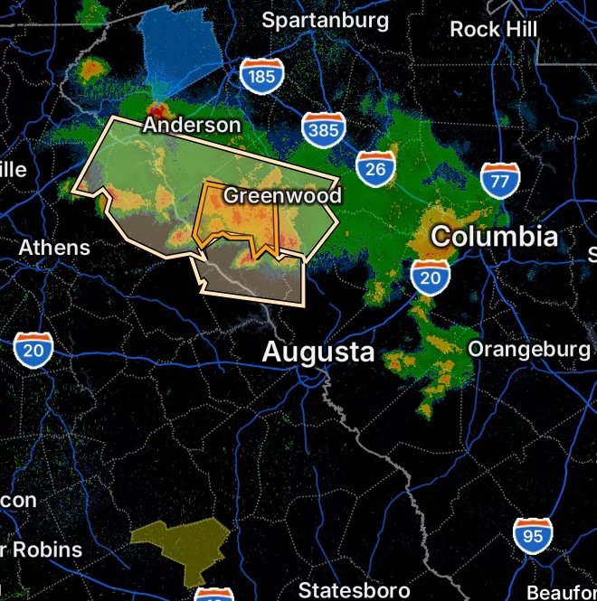
Severe thunderstorms are moving across parts of Upstate South Carolina this evening, bringing the potential for damaging wind gusts, hail, frequent lightning and torrential rainfall. A Severe Thunderstorm Warning has been issued for portions of Abbeville County, including communities around Abbeville, Calhoun Falls, Troy, Promised Land and surrounding areas.
Radar Watch HQ is monitoring the active weather situation and the potential for additional impacts as thunderstorms move through the region.
Severe Thunderstorm Warning: Abbeville County
The National Weather Service has warned of a severe thunderstorm affecting Abbeville County and western Greenwood County. Communities specifically impacted include:
- Abbeville
- Calhoun Falls
- Troy
- Promised Land
- Due West
- Donalds
- Cokesbury
- Hodges
- Shoals Junction
The warning included a threat for 60 mph wind gusts and hail, with radar indicating the potential for hail up to around 1.5 inches in diameter. The National Weather Service noted that strong winds could damage trees and power lines. (Tornado HQ)
Residents in the warned area should move indoors and stay away from windows as the storm approaches.
Areas Near Richard B. Russell Dam and Antreville
Storm activity is also important for communities around Richard B. Russell Dam and Antreville, where changing storm tracks can bring sudden increases in wind, lightning and rainfall.
Even when a storm is not directly overhead, strong outflow winds can spread well away from the heaviest rainfall. Outdoor activities around lakes, reservoirs and open areas should be suspended when thunderstorms approach.
Anyone on or near the water should move to a safe location before the storm arrives.
Special Weather Statement Covers a Wider Area
A broader Special Weather Statement covers portions of the Upstate, including:
- Franklin County
- Elbert County
- Hart County
- Southwestern Laurens County
- Southern Anderson County
- Abbeville County
- South-central Oconee County
- Greenwood County
These areas can experience strong thunderstorms even when they are outside the core of the Severe Thunderstorm Warning.
Storms may produce sudden wind gusts, frequent lightning, heavy rainfall and localized hazardous travel conditions.
Power Outages Reported
Thunderstorm-related power outages are also a concern across the region.
Johnson County and Pickens County have reported power-outage impacts associated with the active weather situation. Strong thunderstorm winds can bring down branches and trees, damage utility equipment and interrupt electrical service.
Residents who lose power should stay clear of downed wires and assume that any fallen electrical line is energized. Never approach or attempt to move a downed power line.
Current statewide outage information can change rapidly as utilities update their systems. (PowerOutage.com)
What Residents Should Do Now
If a Severe Thunderstorm Warning is issued for your location:
- Move indoors immediately.
- Stay inside and away from windows.
- Avoid unnecessary travel during the strongest part of the storm.
- Bring outdoor objects inside when it is safe to do so.
- Stay away from trees during strong winds.
- Unplug sensitive electronics if conditions allow and power interruptions become likely.
- Never drive through flooded roadways.
- If lightning is occurring, remain indoors until the storm has safely passed.
- Have flashlights and backup lighting available if the power goes out.
A basement or sturdy interior room on the lowest floor provides additional protection from severe winds. If a basement is unavailable, choose a small interior room away from windows.
Why These Storms Matter
Severe thunderstorms can change rapidly. A storm that begins as a strong thunderstorm can intensify enough to produce damaging wind or large hail, prompting a Severe Thunderstorm Warning.
The greatest immediate concerns with tonight’s storms are damaging wind, hail, lightning, heavy rainfall and localized power outages.
Storm-related hazards can also continue after the strongest rainfall ends, particularly from fallen trees, blocked roads, downed power lines and standing water.
Radar Watch HQ Final Thoughts
Residents across Abbeville, Calhoun Falls, Troy, Promised Land, Antreville, Richard B. Russell Dam and surrounding portions of Upstate South Carolina should remain weather-aware this evening.
A Severe Thunderstorm Warning means conditions are more urgent than a general thunderstorm threat. Take shelter promptly when a warning is issued for your location, and continue monitoring official National Weather Service updates as storms move through.
Stay indoors during the strongest storms, avoid flooded roads and treat all downed power lines as dangerous.
Stay weather-aware and stay safe.