Flood Watch Covers Large Area of New Mexico and Far West Texas
A broad Flood Watch is in effect across portions of New Mexico as forecasters monitor the arrival of another surge of deep monsoon moisture combined with an early-season back-door cold front.
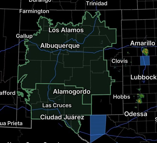
The National Weather Service has identified the potential for flash flooding caused by excessive rainfall, with the watch covering portions of central, east central, north central, northeast, southeast, and west central New Mexico. A separate Flood Watch covers much of south-central New Mexico and Far West Texas, including the El Paso and Las Cruces areas.
The primary concern is repeated rounds of showers and thunderstorms capable of producing very heavy rainfall over the same locations.
When Is the Flood Threat?
For much of New Mexico covered by the Albuquerque National Weather Service office, the Flood Watch is scheduled from Tuesday afternoon through Wednesday afternoon.
Across south-central New Mexico and Far West Texas, the El Paso/Santa Teresa National Weather Service office has the Flood Watch running from Tuesday afternoon through Wednesday evening.
Rain may not fall continuously. Instead, multiple waves of showers and thunderstorms could move through the region, allowing rainfall to accumulate quickly in locations that experience repeated storms.
New Mexico Areas Included
The New Mexico Flood Watch encompasses a wide geographic area.
Central New Mexico includes:
- Central Highlands
- Eastern Lincoln County
- Estancia Valley
- Lower Rio Grande Valley
- Middle Rio Grande Valley, including the Albuquerque Metro Area
- San Agustin Plains and Adjacent Lowlands
- Sandia and Manzano Mountains, including Edgewood
- South Central Highlands
- South Central Mountains
- Upper Tularosa Valley
East-central New Mexico includes De Baca County and Guadalupe County.
North-central New Mexico includes portions of the East Slopes of the Sangre de Cristo Mountains, Española Valley, Glorieta Mesa and Glorieta Pass, Jemez Mountains, Northwest Highlands, Santa Fe Metro Area, and Southern Sangre de Cristo Mountains.
Northeast New Mexico includes Eastern San Miguel County, the Far Northeast Highlands, Harding County, and Northeast Highlands.
Southeast New Mexico includes the Chaves County Plains and Southwest Chaves County.
West-central New Mexico includes the Southwest Mountains, West Central Highlands, and West Central Mountains.
South-Central New Mexico and Far West Texas
A second Flood Watch covers much of south-central New Mexico and Far West Texas, including El Paso, Las Cruces, and the Mesilla Valley.
The National Weather Service in El Paso/Santa Teresa says an early-season back-door cold front will interact with a late-season plume of deep monsoonal moisture. That setup is expected to produce several rounds of thunderstorms with torrential downpours from Tuesday afternoon through Wednesday evening.
The greatest concern is localized flooding of arroyos, streams, rivers, low-lying areas, and locations with poor drainage. Low-water crossings could also become flooded and lead to road closures.
Why Flash Flooding Could Develop Quickly
Heavy rainfall is especially concerning when thunderstorms repeatedly move across the same area.
The current setup could produce rainfall rates capable of overwhelming drainage systems, washes, and normally dry channels. Areas with complex terrain, recent wildfire burn scars, saturated ground, urban development, and low-lying drainage areas can respond particularly quickly to intense rainfall.
The National Weather Service expects widespread heavy rainfall across parts of New Mexico, with stronger thunderstorms capable of producing torrential rainfall and locally much higher totals where storms repeatedly track over the same locations.
Albuquerque, Santa Fe, Las Cruces and El Paso
Residents in and around Albuquerque, Santa Fe, Las Cruces, and El Paso should pay close attention to changing weather conditions during the watch period.
Urban flooding can develop even when a location is not directly next to a river or creek. Intense rainfall can overwhelm storm drains, flood streets, and create dangerous water depths in low-lying areas.
In mountainous areas, rainfall can also move rapidly downhill into arroyos and drainage channels.
Flood Safety: Never Drive Through Floodwater
One of the most important precautions during this event is to avoid flooded roads.
Never drive through floodwater. Water depth can be difficult to judge, and moving water can sweep vehicles from roadways. The National Weather Service specifically advises people to be prepared to take action if Flash Flood Warnings are issued.
If a road is covered by water, turn around and find another route. Do not attempt to cross a flooded low-water crossing, arroyo, wash, or drainage channel.
Residents in flood-prone locations should also monitor official warnings and be prepared to move to safer ground if flooding develops.
What to Watch for Tuesday Through Wednesday
The main threats include:
- Torrential rainfall from thunderstorms
- Flash flooding
- Rapid rises in creeks and streams
- Flooding of normally dry arroyos and washes
- Urban and poor-drainage flooding
- Flooded low-water crossings
- Road closures
- Rapid runoff from mountainous terrain
- Increased flooding potential near recent burn scars
Conditions can change rapidly once thunderstorms begin developing, so a Flood Watch should be treated as a period to prepare before flooding occurs.
Radar Watch HQ Final Thoughts
This is a large-area rainfall and flooding concern, stretching across much of New Mexico and into Far West Texas. The combination of deep monsoon moisture, a back-door cold front, and repeated thunderstorms could produce periods of very heavy rain from Tuesday into Wednesday.
Stay weather-aware, keep alerts enabled, avoid flooded roads, and be ready to respond quickly if a Flash Flood Warning is issued for your location.
Stay ahead of the weather. Stay prepared. Stay safe.