Flooding Remains a Major Concern Across New Mexico
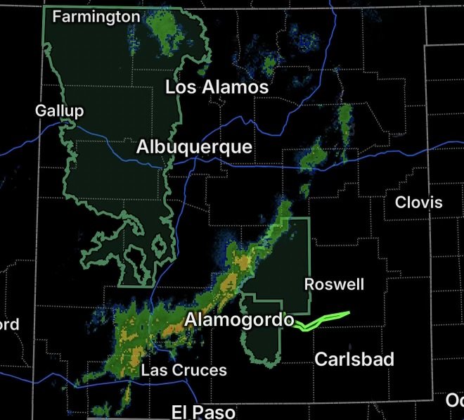
A renewed threat of heavy rainfall and flash flooding is affecting portions of New Mexico today, with Flood Watches covering areas of west central and northwest New Mexico, the South Central Mountains and Eastern Lincoln County. The National Weather Service says the watch is in effect from noon MDT through this evening on September 18.
The concern is heightened by very saturated soils following days of soaking rainfall. The National Weather Service says thunderstorms could produce rainfall rates of approximately 1 to 1.5 inches per hour, allowing water to run off quickly into creeks, streams and other flood-prone areas.
Areas with steep terrain, saturated ground, urban development and wildfire burn scars can experience rapid changes when additional heavy rain develops.
Flood Watch for Western and Central New Mexico
The Flood Watch includes portions of west central and northwest New Mexico, along with the South Central Mountains and Eastern Lincoln County.
The watch includes the Ruidoso area burn scars, where additional rainfall can produce particularly rapid runoff. The National Weather Service identifies burn scars, saturated soils, complex terrain and areas with limited drainage as locations at increased risk for flash flooding.
Thunderstorms are expected to develop or intensify during the afternoon and evening. While storms across western New Mexico are expected to diminish during the evening, storms affecting Lincoln County could continue as late as midnight.
Residents should remain alert for changing conditions and be prepared to act if a Flash Flood Warning is issued.
Sacramento Mountains and Communities at Risk
Flooding concerns also extend into the Sacramento Mountains in northern Otero County, including communities such as Ruidoso, Cloudcroft, Mescalero and Mayhill.
The National Weather Service has highlighted the Sacramento Mountains because storms can repeatedly move over the same areas, increasing rainfall totals and runoff. Recent rainfall has also left soils across parts of south-central New Mexico with elevated moisture, meaning additional rainfall may produce runoff quickly.
Mountain roads, arroyos, drainage channels and low-water crossings can become dangerous with little notice.
Flood Warning: Southeastern Lincoln County and West Central Chaves County
A more immediate flooding concern is in effect across southeastern Lincoln County in central New Mexico and west central Chaves County in southeastern New Mexico.
The National Weather Service issued a Flood Warning through 2:15 p.m. MDT Friday, with flooding associated with excessive rainfall.
The warning area includes Whitetail Canyon, Picacho Road, including Clements Ranch, and areas along the Rio Felix. Officials reported that 3 to 5 inches of rain had already fallen, with additional rainfall possible. Flooding of low-water crossings along the Rio Felix is expected.
This is an important distinction for residents: a Flood Watch means conditions are favorable for flooding, while the Flood Warning indicates flooding is occurring or expected in the warned area.
Why Additional Rain Could Cause Problems
When the ground is already saturated, rainfall cannot infiltrate as efficiently. Instead, water can move rapidly across the surface and collect in drainage areas, creeks, arroyos and low-lying locations.
In mountainous areas, steep slopes can accelerate runoff, while wildfire burn scars can further increase the potential for sudden flooding and debris flows.
Even locations that are not currently receiving heavy rain can experience flooding downstream as water moves through drainage systems.
Flood Safety: Never Drive Through Floodwater
If you encounter a flooded roadway, turn around and find another route. Do not attempt to drive through moving or standing floodwater when its depth or condition is unknown.
Flooded roads can conceal washed-out pavement, debris, damaged bridges and deep channels. Water can also rise rapidly, particularly near creeks, arroyos and low-water crossings.
At night, flooding can be especially difficult to see.
Residents in and around the Flood Watch and Flood Warning areas should monitor official weather updates throughout the day and be ready to move to a safer location if conditions deteriorate.
What New Mexico Residents Should Watch Today
Key concerns include:
- Heavy thunderstorms during the afternoon and evening
- Rainfall rates capable of producing rapid runoff
- Saturated soils and elevated runoff potential
- Flash flooding near mountain terrain
- Flooding near wildfire burn scars
- Rising creeks, streams and arroyos
- Dangerous low-water crossings
- Continued flooding in parts of southeastern Lincoln and west central Chaves Counties
The current situation can change quickly as thunderstorms develop. Continue monitoring official National Weather Service updates for new or expanded Flood Warnings.
Stay weather-aware, avoid flooded roadways, and never risk driving through floodwater. When water covers the road, turn around.
Radar Watch HQ Final Thoughts
New Mexico remains vulnerable to additional flooding as saturated ground combines with more thunderstorms across the mountains and surrounding communities. The most immediate concern is in areas already under a Flood Warning, while residents across the broader Flood Watch should be prepared for rapidly developing flash flooding.
Stay alert, stay informed, and make safety the priority when flooding develops.