Category 4 Typhoon Dolphin Near Wake Island
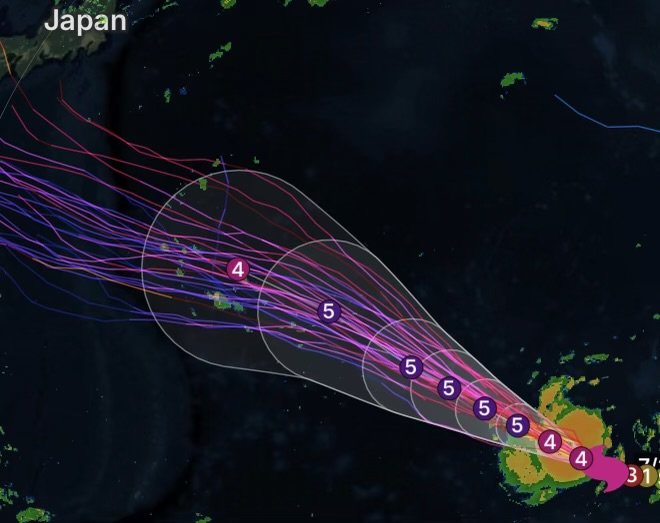
Category 4 Typhoon Dolphin remains a powerful tropical cyclone in the western Pacific Ocean, located approximately 395 miles south-southeast of Wake Island as of July 29, 2026. The storm continues to move over open waters while producing destructive winds, dangerous seas, and large swells across the region.
Although the center of the typhoon remains well away from major population centers, conditions near Wake Island are being closely monitored due to the potential for hazardous marine conditions, heavy rainfall, and powerful wind gusts if the storm tracks closer to the island.
Typhoon Dolphin Current Status
As a Category 4 typhoon, Dolphin is capable of producing:
- Sustained winds exceeding 130 mph
- Extremely rough seas with dangerous wave heights
- Torrential rainfall capable of reducing visibility
- Hazardous surf and strong rip currents
- Dangerous conditions for marine and aviation operations
Forecasters continue to monitor the storm’s intensity and track as environmental conditions may allow fluctuations in strength over the coming days.
Wake Island Monitoring Conditions
Wake Island remains under close observation as the powerful typhoon moves through the western Pacific. Even if the storm’s center stays offshore, impacts can still include:
- Large ocean swells
- Dangerous surf
- Strong wind gusts
- Periods of heavy rain
- Hazardous conditions for ships and aircraft
Residents and personnel on Wake Island should continue following official weather updates and any instructions issued by local authorities.
Marine Hazards
Mariners should avoid the vicinity of Typhoon Dolphin whenever possible. Seas surrounding the cyclone are extremely dangerous, with hurricane-force winds capable of producing life-threatening conditions.
Potential marine impacts include:
- Very high seas
- Powerful wave action
- Reduced visibility in heavy rain
- Strong and shifting winds
- Dangerous navigation conditions
Continue Monitoring Official Forecasts
Typhoon Dolphin remains a significant tropical cyclone, and its future track and intensity could change over the coming days. Anyone with interests near Wake Island or operating across the western Pacific should stay informed through official weather agencies and marine forecasts.
At Radar Watch HQ, we continue providing timely updates on tropical systems, hurricanes, typhoons, severe weather, floods, wildfires, and other significant weather events. Follow us for the latest forecasts and safety information as Typhoon Dolphin continues across the Pacific.
Radar Watch HQ Top 5 Marine Essentials
Affiliate Disclosure: As an Amazon Associate, Radar Watch HQ earns from qualifying purchases.
🌊 1. U.S. Coast Guard-Approved Life Jacket
A properly fitted life jacket is the most important piece of safety equipment for every passenger onboard.
Best for: Recreational boaters, anglers, kayakers, and paddleboarders.
⚓ 2. Marine Emergency Radio (NOAA Weather Radio)
Receive real-time NOAA Weather Radio alerts, marine forecasts, and emergency warnings—even when cell service is unavailable.
Best for: Offshore and coastal boating.
🔦 3. Rechargeable Waterproof LED Flashlight
A bright waterproof flashlight is essential for emergencies, low visibility, nighttime navigation, and signaling for help.
Best for: Every boat emergency kit.
🧰 4. Marine First Aid Kit
A waterproof first aid kit stocked with bandages, antiseptic, medications, and emergency supplies for injuries on the water.
Best for: Every vessel, regardless of size.
🧭 5. Waterproof Dry Bag
Protect phones, wallets, charts, keys, electronics, and emergency supplies from water damage during storms or rough seas.
Best for: Boaters, kayakers, paddleboarders, and beachgoers.
🛒 Radar Watch HQ Marine Safety Picks
Prepare before you head out on the water. Our recommended marine safety essentials can help keep you and your crew safe during changing weather conditions.