Post-Tropical Cyclone Isaias Leaves Multiple Weather Hazards
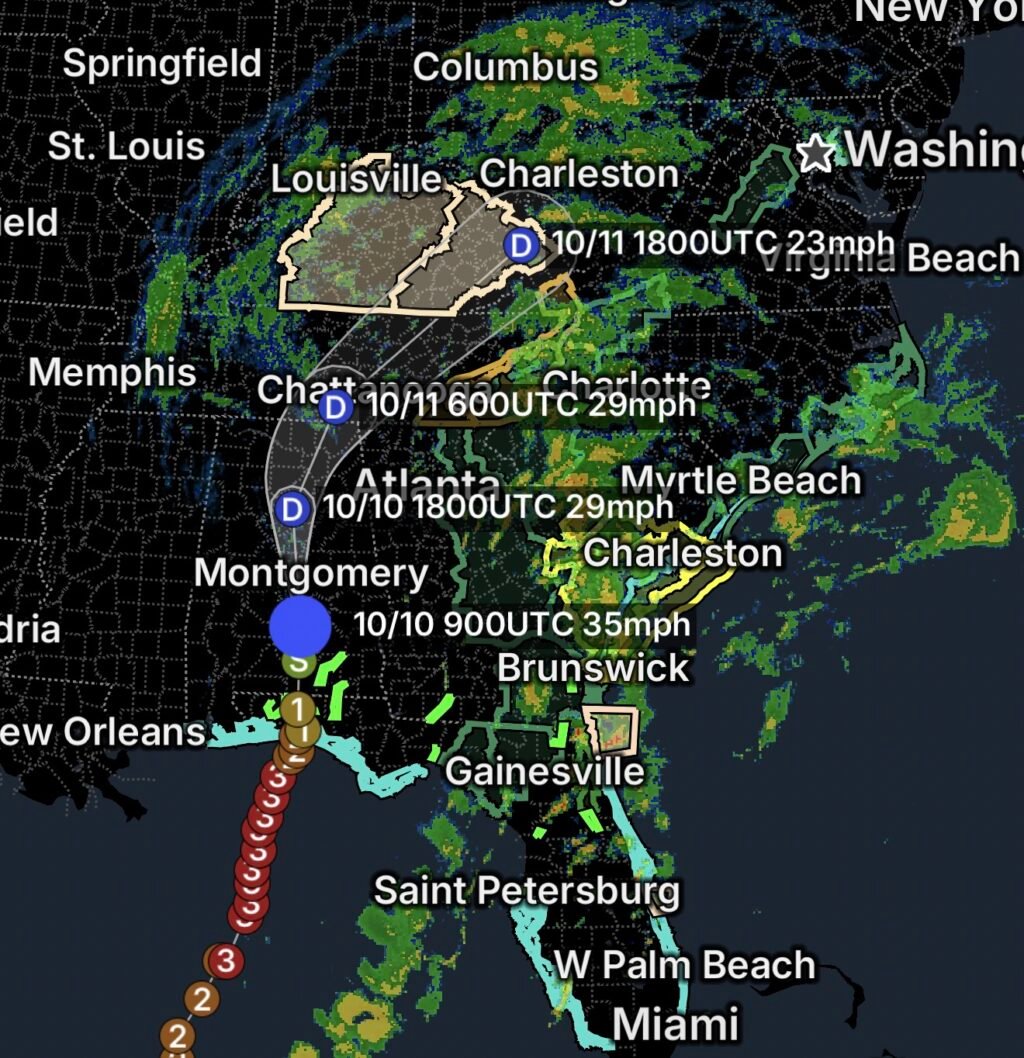
Post-Tropical Cyclone Isaias is associated with a broad range of reported weather alerts across Florida, Georgia, South Carolina, North Carolina, and nearby regions on Saturday, October 10, 2026.
Although a system is classified as post-tropical when it no longer meets the definition of a tropical cyclone, it can still produce dangerous winds, rough seas, heavy rainfall, and other significant hazards.
The reported alerts include marine weather concerns along the Florida and Georgia coasts, dangerous rip currents, a Tornado Watch for portions of Georgia and South Carolina, Flood Watches extending into parts of the Southeast, and a High Wind Warning across much of the mountains of western North Carolina.
Residents and visitors should monitor local forecasts and follow instructions from emergency officials.
1. Florida: Marine Weather and Rip Current Hazards
A Marine Weather Watch has been reported for waters from the Volusia–Brevard County line to Sebastian Inlet, extending 0–20 nautical miles offshore.
Rip Current Statements have also been reported for:
- Coastal Volusia County
- Indian River County
- St. Lucie County
- Martin County
- Brevard County
- Pinellas County
- Coastal Hillsborough County
Rip currents are powerful channels of water that flow away from shore. They can pull swimmers away from the beach, even when the water appears relatively calm.
Beach safety essentials:
- Swim at beaches with lifeguards when possible.
- Follow posted beach warnings and closures.
- Never enter the water during dangerous surf conditions.
- If caught in a rip current, remain calm, float if necessary, and swim parallel to shore until free of the current before returning to land.
- Call for help if you cannot safely reach shore.
2. Georgia and Northeast Florida: Hazardous Coastal Waters
Marine Weather Statements have been reported for coastal waters covering:
- Altamaha Sound, Georgia, to Fernandina Beach, Florida, out to 20 nautical miles
- Fernandina Beach to St. Augustine, Florida, out to 20 nautical miles
- Waters from Altamaha Sound to Fernandina Beach, 20–60 nautical miles offshore
- Waters from Fernandina Beach to St. Augustine, 20–60 nautical miles offshore
Changing winds, rough seas, and reduced visibility can make boating dangerous, particularly for smaller vessels.
Mariners should check updated marine forecasts, avoid unnecessary trips into hazardous waters, secure equipment, and follow Coast Guard and local authority guidance.
3. Tornado Watch for Portions of Georgia and South Carolina
A Tornado Watch has been reported for portions of eastern Georgia, southern and eastern South Carolina, and coastal waters.
A Tornado Watch means conditions are favorable for tornado development. It does not mean a tornado is occurring at every location within the watch area.
Residents should remain alert for warnings, identify a sturdy shelter, and keep phones charged with emergency alerts enabled.
If a Tornado Warning is issued for your location, move immediately to a basement or a small interior room on the lowest floor, away from windows.
4. Flood Watches Across the Southeast
Flood Watches have been reported for portions of:
- Southeast Georgia
- Northeast Georgia
- North Carolina
- Southwest Virginia
Heavy rainfall can cause rising water, localized flooding, and dangerous conditions along streams and low-lying roads. Mountainous terrain can also funnel runoff into narrow valleys and drainage areas.
Residents should avoid flooded roads and monitor water levels where flooding is possible.
Turn around, don’t drown! Never drive through floodwater, even if the road appears passable.
5. High Wind Warning for Western North Carolina Mountains
A High Wind Warning has been reported for most of the mountains of western North Carolina.
Strong winds can break branches, bring down trees, damage property, and cause power outages. Mountain roads may be particularly hazardous where gusts affect exposed ridges, passes, and elevated routes.
Residents should secure loose outdoor items, avoid wooded areas during strong winds, and stay well away from downed power lines.
Prepare for possible outages by charging essential devices and keeping flashlights and emergency supplies accessible.
6. Special Weather Statements Across Multiple States
Special Weather Statements have also been reported for portions of Kentucky, Indiana, Ohio, and Louisiana.
These statements can highlight localized weather conditions that may become hazardous, including strong wind gusts, heavy downpours, or rapidly changing storm conditions. The specific threat depends on the individual statement.
Residents should review the statement for their county or community and follow any recommended precautions.
Essentials: How to Stay Safe
- ☐ Monitor local weather alerts and official updates on Isaias’s post-tropical impacts.
- ☐ Avoid swimming in areas affected by rip current statements.
- ☐ Stay out of hazardous coastal waters and check marine forecasts before boating.
- ☐ Be prepared to shelter immediately if a Tornado Warning is issued.
- ☐ Avoid flooded roads, streams, and low-lying areas.
- ☐ Secure outdoor belongings and prepare for strong winds and possible power outages.
- ☐ Follow evacuation or emergency instructions from local officials.
The Bottom Line
Post-Tropical Cyclone Isaias is associated with multiple reported hazards across Florida and the Southeast on October 10, 2026. Dangerous rip currents and marine conditions threaten coastal areas, while tornado potential, flooding, and high winds pose additional risks farther inland.
Stay out of dangerous surf, take tornado and flood alerts seriously, and prepare for strong winds. Continue monitoring official weather updates because hazards and alert boundaries can change.
Stay alert, stay sheltered when necessary, and never underestimate coastal or inland storm hazards.