


















Kaiser Canyon Fire Update: Evacuations Expand Across Okanogan and Ferry Counties as Smoke Degrades Regional Air Quality
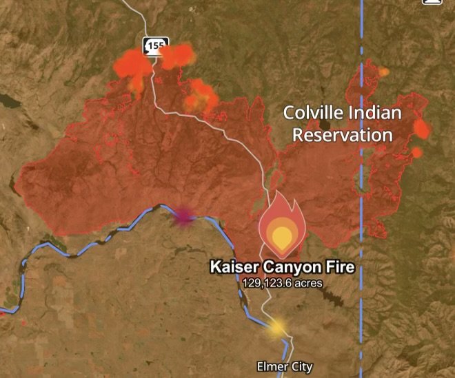
As the scorching summer weather fuels intense fire activity across the Pacific Northwest, the Kaiser Canyon Fire continues to challenge hundreds of firefighting personnel. Burning across portions of the Colville Indian Reservation in Okanogan and Ferry counties, the massive wildfire has triggered urgent safety protocols, mandatory evacuations, and severe air quality alerts throughout the region.
Here is everything you need to know about the current footprint of the fire, evacuation orders, containment efforts, and how heavy smoke is impacting local air quality.
Fire Profile: Size, Growth, and Containment Status
Ignited by lightning strikes, the Kaiser Canyon Fire has rapidly evolved into a complex, high-priority incident. Driven by bone-dry timber, thick brush, and gusty winds, the fire footprint has expanded drastically over the past several weeks.
Total Acreage: Approximately 129,123.6 acres
Containment: 27% contained as ground crews and heavy aerial equipment construct strategic control lines.
Location: Burning south of Buffalo Lake Road near Nespelem, impacting both Okanogan and Ferry counties.
While incident management teams have made substantial progress carving out direct and indirect fire lines—particularly along critical northern and eastern perimeters—hot, dry conditions continue to test containment efforts.
Evacuation Orders and Emergency Alerts
With rapid rates of spread and unpredictable wind shifts, local authorities and tribal emergency management have implemented strict multi-tier evacuation orders to protect residents.
Level 3: “Go Now” Mandatory Orders
Active Level 3 evacuation orders remain in place for heavily threatened zones. Residents in these sectors must evacuate immediately, as remaining poses an extreme risk to life:
Portions of the State Route 155 corridor, including areas from Coyote Creek Campground down to Haley Creek and Omak Lake Road.
Sections along the Highway 21 corridor from South Empire Creek to South Nanamkin Creek Road.
The Columbia River Campground and surrounding high-risk encampments.
Level 2: “Set” Warnings
Surrounding communities—including parts of Nespelem—remain under Level 2 “Set” warnings, meaning residents should be packed and prepared to leave at a moment’s notice.
Emergency shelters have been established at locations such as the Lake Roosevelt High School Gym in Coulee Dam, the Omak Community Center, and the Omak Longhouse. Livestock and large animal shelters are operational at the Okanogan County Fairgrounds and local rodeo grounds.
How the Kaiser Canyon Fire is Impacting Regional Air Quality
The sheer volume of acreage burned by the Kaiser Canyon Fire has pumped massive quantities of particulate matter (\bm{PM_{2.5}} and \bm{PM_{10}}) and toxic smoke into the lower atmosphere.
Widespread Unhealthy Air Conditions
Communities situated downwind on the Colville Reservation, the Okanogan River Valley, the San Poil Valley, and the Columbia River Valley are bearing the brunt of the smoke.
Air Quality Index (AQI): Index readings across multiple localized monitors have fluctuated between Unhealthy and Hazardous, depending on wind patterns and overnight inversions that trap smoke in valley bottoms.
Visibility Restrictions: Heavy palls of smoke have drastically reduced visibility along major transit routes, complicating both driving conditions and daytime aerial firefighting drops.
Health Recommendations for Residents
Health departments across Okanogan and Ferry counties urge residents in affected zones to take immediate precautions:
1. Stay Indoors: Keep doors, windows, and fireplace dampers tightly shut.
2. Run Air Purifiers: Utilize HEPA-certified indoor air scrubbers and set home HVAC systems to recirculate mode.
3. Wear Protection: If outdoor exposure is unavoidable, wear a tightly fitted N95 or KN95 respirator mask rather than a standard cloth mask.
Outlook and Next Steps
Fire behavior remains highly active during peak afternoon heating hours, though cooler overnight recoveries and coordinated multi-agency responses are aiding containment progress. Residents are advised to monitor real-time updates via local emergency channels, Watch Duty maps, and local air quality tracking applications as firefighters work to secure full perimeter control.
Affiliate Disclosure: As an Amazon Associate, Radar Watch HQ earns from qualifying purchases.
Radar Watch HQ Top 5 Essentials – Wildfire Preparedness
Helps reduce exposure to wildfire smoke, ash, and fine particles.
Provides alerts during power outages or when cell service is unavailable.
Go Bag / Emergency Preparedness Kit
Includes important documents, medications, water, food, flashlights, and basic supplies for quick evacuation.
Fire-Resistant Outdoor Supplies
Items such as fire-resistant gloves, protective clothing, and tools for creating defensible space around property.
Portable Power Bank & Backup Charging Supplies
Keeps phones and emergency devices powered during wildfire emergencies.