Pacific Tropical Disturbances Being Monitored as Development Chances Remain Low
Meteorologists are monitoring several areas of disturbed weather across the East and Central Pacific as tropical waves and developing low-pressure areas move across the basin. While none of the systems are expected to become a tropical depression in the immediate future, conditions could become slightly more favorable for gradual organization later this week and into early next week.
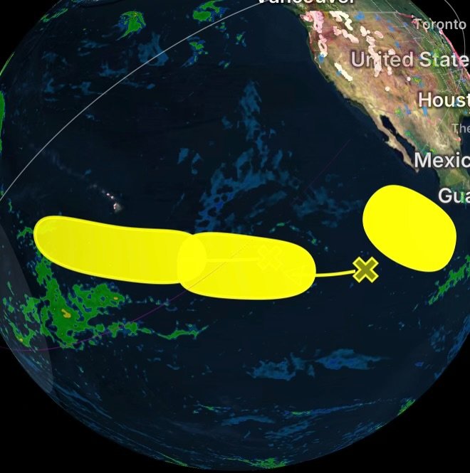
Three separate areas of interest are currently being tracked, including one system expected to form offshore of Mexico and two tropical waves moving westward across the Pacific.
Central East Pacific: Area of Interest #3 Offshore of Mexico
A broad area of low pressure is forecast to develop well offshore of the southwestern coast of Mexico late this weekend or early next week.
After formation, the system could experience some gradual development while moving generally west-northwestward over the open Pacific waters.
Current development chances remain low:
- Formation chance through 48 hours: Near 0%
- Formation chance through 7 days: 20%
Because the disturbance is expected to remain far from land, impacts to coastal areas are not currently expected. However, tropical conditions will continue to be monitored as the system evolves.
Western East Pacific: Area of Interest #2
A tropical wave located over the central portion of the East Pacific is producing limited shower and thunderstorm activity.
Environmental conditions may become somewhat more favorable for gradual development late this weekend into early next week as the disturbance moves generally westward at approximately 10 to 15 mph.
Current development chances:
- Formation chance through 48 hours: Near 0%
- Formation chance through 7 days: 20%
The system remains disorganized, with limited thunderstorm activity currently preventing stronger development. Forecast models will continue to monitor whether the disturbance can become better organized.
Central Pacific: Area of Interest #1
A tropical wave located over the western portion of the East Pacific is producing limited and disorganized showers and thunderstorms.
Development, if it occurs, is expected to be slow as the system moves westward at approximately 10 to 15 mph over the next several days.
At this time, the disturbance remains weak and does not show significant signs of organization. Continued monitoring will determine whether environmental conditions improve.
What These Tropical Disturbances Mean for the Pacific
The Pacific hurricane season continues to produce multiple areas of tropical activity, but current disturbances remain below tropical cyclone thresholds.
Key factors being monitored include:
- Increasing thunderstorm organization
- Warm ocean temperatures
- Wind shear levels
- Moisture availability
- Future movement and interaction with the surrounding environment
Most tropical waves never become named storms, but early monitoring helps forecasters identify potential changes before systems strengthen.
Radar Watch HQ Tropical Weather Update
Radar Watch HQ will continue tracking these Pacific disturbances and provide updates as conditions change. Tropical systems can strengthen quickly, so staying informed throughout hurricane season remains important.
Stay weather aware and follow Radar Watch HQ for the latest tropical outlooks, storm tracking, and severe weather updates.