Pacific Hurricane Activity Remains Elevated as Lowell, Karina and Marie Track Across the Eastern and Central Pacific
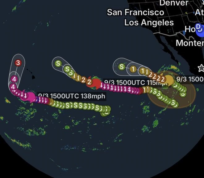
The Pacific is staying remarkably active as Category 4 Hurricane Lowell, Category 3 Hurricane Karina, and Category 1 Hurricane Marie continue across the eastern and central Pacific. At the same time, forecasters are monitoring another area of disturbed weather that could organize into a tropical depression next week well offshore of southwestern Mexico.
According to the National Hurricane Center, all three named hurricanes are currently being monitored, while a separate area of low pressure has a 40% chance of tropical cyclone formation during the next seven days. (National Hurricane Center)
For now, the biggest concern is not a direct landfall from all three hurricanes. Instead, the storms are producing dangerous ocean conditions, large swells and hazardous surf across portions of the Pacific while forecasters closely watch their changing tracks.
Hurricane Lowell: Powerful Category 4 Hurricane
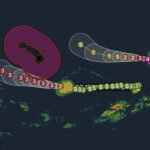
Hurricane Lowell remains a major hurricane over the central Pacific.
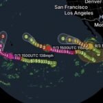
The latest National Hurricane Center advisory information showed Lowell with maximum sustained winds near 155 mph, making it a Category 4 hurricane. Lowell was located approximately 440 miles south of Hilo, Hawaii, and was moving west at around 10 mph. (National Hurricane Center)
Lowell has undergone an impressive period of rapid strengthening. The storm developed a compact, well-defined eye surrounded by extremely deep thunderstorms, characteristics commonly associated with a powerful tropical cyclone. (National Hurricane Center)
Although no coastal watches or warnings were in effect in the cited advisory, the storm’s large waves and swells remain a concern for mariners and coastal communities.
Why Lowell Is Being Closely Watched
Forecast changes will be particularly important because steering currents can shift a hurricane’s direction several days into the future.
Even if the center remains offshore, Lowell can still generate:
- Dangerous surf
- Powerful rip currents
- Large ocean swells
- Hazardous conditions for boats
- Strong winds over open water
- Dangerous conditions for swimmers and surfers
Residents and visitors in Hawaii should continue monitoring official forecasts rather than relying on social media storm tracks.
Hurricane Karina: Category 3 Hurricane in the Pacific
Hurricane Karina is another major hurricane contributing to the unusually active Pacific pattern.
Karina is located well east of the Hawaiian Islands, while continuing to move across the open Pacific. The hurricane remains far from land, but its circulation is capable of producing significant ocean swells and dangerous marine conditions.
Karina’s location over warm Pacific waters has supported its strengthening. However, tropical cyclones can change intensity quickly when environmental conditions such as ocean temperatures, wind shear and atmospheric moisture change.
Karina’s Main Concern: Dangerous Ocean Conditions
Even when a hurricane stays hundreds of miles offshore, its impacts can extend well beyond the center.
Large swells generated by Karina can travel outward through the Pacific, potentially creating hazardous surf and rip currents along exposed coastlines.
Beachgoers should never judge ocean danger solely by how calm the weather appears on shore.
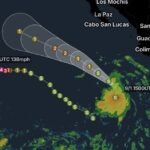
Hurricane Marie: Category 1 Hurricane Southwest of Baja California
Hurricane Marie is the third active hurricane in the Pacific.
Marie is located several hundred miles southwest of the southern tip of the Baja California Peninsula. The National Hurricane Center upgraded Marie from a tropical storm to a hurricane as the system strengthened over the Pacific. (National Hurricane Center)
Marie is another reminder that tropical systems can intensify rapidly over favorable ocean conditions.
While Marie is expected to remain offshore, residents along the Pacific coast should continue monitoring surf forecasts, especially because large swells can arrive before a tropical cyclone approaches its closest point to land.
New Area of Development Offshore Southwestern Mexico
Adding another layer to the Pacific’s busy pattern, forecasters are monitoring an area of low pressure that could form well offshore of southwestern Mexico.
The National Hurricane Center says gradual development is possible over the weekend or early next week. The disturbance could potentially become a tropical depression around the middle of next week.
The system is expected to move west-northwestward at approximately 10 to 15 mph and will likely remain well offshore of Mexico. (National Hurricane Center)
Tropical Development Chances
The National Hurricane Center currently gives the disturbance:
Through 48 hours: Near 0% chance of formation
Through 7 days: 40% chance of formation (National Hurricane Center)
That means there is no immediate tropical cyclone threat from this disturbance, but conditions could become more favorable during the coming days.
Because tropical systems can evolve quickly once organized thunderstorms develop around a low-pressure center, continued monitoring will be important.
Why the Pacific Is So Active
The eastern and central Pacific can become extremely active when several environmental ingredients come together.
Tropical cyclones generally require:
- Warm ocean water to provide energy.
- Moist atmospheric conditions to support thunderstorms.
- Low or moderate vertical wind shear so thunderstorms can remain organized.
- A pre-existing disturbance around which thunderstorms can consolidate.
- Sufficient rotation to help a tropical circulation develop.
When several of these ingredients overlap, tropical systems can strengthen rapidly.
The result can be a chain of tropical cyclones developing across the Pacific within a relatively short period.
What This Means for Mexico, Baja California and Hawaii
The current hurricane pattern does not mean that every active hurricane will make landfall.
In fact, the National Hurricane Center’s latest Tropical Weather Outlook emphasizes that Lowell, Karina and Marie are located over the Pacific, while the new disturbance offshore southwestern Mexico is expected to remain well offshore. (National Hurricane Center)
However, coastal impacts do not require a direct landfall.
Potential Coastal Hazards
Depending on storm intensity and distance from shore, tropical systems can produce:
- Large breaking waves
- Dangerous rip currents
- High surf
- Coastal erosion
- Dangerous boating conditions
- Strong offshore winds
- Heavy rainfall from outer bands
- Localized coastal flooding in vulnerable areas
Beach conditions can become dangerous even when skies are partly sunny and there is little wind directly overhead.
Pacific Ocean Safety Reminder
If you are heading to the beach, check local surf and beach hazard forecasts before entering the water.
Never attempt to swim against a rip current. If caught in one, remain calm and swim parallel to the shoreline until you escape the current, then angle back toward the beach.
Boaters should also check marine forecasts carefully because tropical swells can create dangerous conditions far from the storm’s center.
What to Watch Next
The next several days will be important for tracking the evolution of the Pacific hurricane pattern.
Forecasters will be watching:
- Lowell’s future movement near Hawaii
- Changes in Lowell’s intensity
- Karina’s strength and track
- Marie’s continued evolution southwest of Baja California
- Development of the new disturbance offshore southwestern Mexico
- Ocean temperatures and atmospheric wind shear
- Changes in Pacific swell and surf conditions
Most importantly, forecast tracks can change as new observations and computer model guidance become available.
Radar Watch HQ Final Thoughts
The Pacific is entering a highly active stretch with Hurricane Lowell, Hurricane Karina and Hurricane Marie all being tracked simultaneously, while another potential tropical system could emerge offshore southwestern Mexico next week.
For coastal residents, travelers and mariners, the biggest immediate takeaway is simple: a hurricane does not have to make landfall to create dangerous conditions.
Large swells, powerful surf and rip currents can travel far from a tropical cyclone.
Meanwhile, the potential disturbance near southwestern Mexico remains something to watch rather than an immediate threat. With a 40% seven-day formation chance, there is enough potential for development to warrant continued monitoring, but there is also substantial uncertainty this far in advance. (National Hurricane Center)
Radar Watch HQ will continue following the Pacific tropics as these systems evolve.
Stay weather-aware, check official forecasts frequently, and never underestimate the ocean during an active tropical season.
Stay informed. Stay prepared. Stay weather-aware with Radar Watch HQ.