

















Hurricane Lowell and Hurricane Karina Highlight Active Eastern Pacific
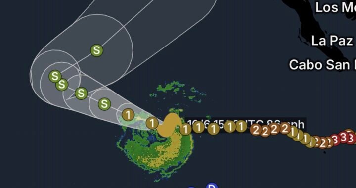
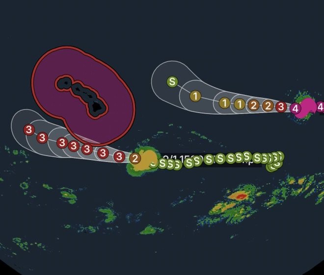
The Pacific remains highly active as Category 1 Hurricane Lowell and Category 4 Hurricane Karina continue to track across the eastern and central Pacific. Lowell is located approximately 575 miles southeast of Hilo, Hawaii, while powerful Hurricane Karina is about 1,280 miles west-southwest of the southern tip of Baja California.
At the same time, marine conditions around Hawaii are becoming increasingly hazardous, with Tropical Storm Warning and Storm Warning conditions in Hawaiian offshore waters.
Although these systems are separated by hundreds of miles, their presence highlights the importance of monitoring updated forecasts, especially for mariners and coastal communities.
Category 1 Hurricane Lowell 575 Miles Southeast of Hilo
Hurricane Lowell is currently a Category 1 hurricane, positioned roughly 575 miles southeast of Hilo, Hawaii.
Its location places the storm well offshore, but the distance does not eliminate potential impacts. Tropical systems can produce large swells, dangerous surf, strong winds and hazardous marine conditions far from the center of circulation.
What Hawaii Should Monitor
For residents and visitors across the Hawaiian Islands, the most important concerns at this stage are likely to remain focused on:
- Dangerous ocean conditions
- Increasing swells and surf
- Strong offshore winds
- Heavy rainfall if outer bands approach
- Rapid changes in marine conditions
- Dangerous rip currents near beaches
Forecast confidence can also change as a hurricane moves through the Pacific. Therefore, residents should continue monitoring official updates rather than relying on a single forecast.
Category 4 Hurricane Karina Remains Far From Baja California
Farther east, Category 4 Hurricane Karina is located approximately 1,280 miles west-southwest of the southern tip of Baja California.
A Category 4 hurricane represents an extremely powerful tropical cyclone with the potential to produce catastrophic damage if its core moves over land. However, Karina’s current position is far offshore, meaning its present location does not automatically indicate a direct threat to Baja California.
Why Karina Still Matters
Even when a major hurricane remains offshore, it can generate significant ocean swells that travel long distances.
Consequently, coastal areas should pay attention to future forecasts for:
- Increasing surf
- Dangerous rip currents
- Large swells
- Hazardous conditions for swimmers and surfers
- Dangerous conditions for small boats
The eventual track and intensity of Karina will determine whether meaningful impacts develop closer to Mexico.
Tropical Storm Warning for Hawaiian Offshore Waters
A Tropical Storm Warning for Hawaiian offshore waters signals that tropical-storm-force winds are possible or expected within the designated marine area.
For mariners, this is particularly important because conditions can deteriorate quickly around tropical cyclones.
Small craft should avoid attempting to navigate through deteriorating conditions. Larger vessels should closely monitor marine forecasts and make preparations well before hazardous winds and seas arrive.
Storm Warning Issued for Hawaiian Offshore Waters
A Storm Warning also indicates dangerous marine conditions. Strong winds combined with building seas can create extremely difficult conditions, even for experienced mariners.
Boat operators should review their route, secure vessels and equipment, and follow guidance from the National Weather Service and local authorities.
Those already at sea should not wait until conditions become severe before making safety decisions.
Pacific Hurricane Safety: What to Know
Tropical systems can affect Hawaii and the surrounding Pacific waters well before the center of a storm approaches.
For Coastal Residents
Residents should:
- Monitor updated tropical forecasts.
- Keep emergency supplies ready.
- Secure loose outdoor objects.
- Stay away from hazardous surf.
- Avoid flooded roads and low-lying areas.
- Follow evacuation or emergency instructions if issued.
For Beachgoers
Large swells and powerful currents can make normally calm beaches dangerous.
If warnings or advisories are posted, stay out of the water and avoid areas near breaking waves, rocks and jetties.
For Mariners
Mariners should take tropical warnings seriously. Rapidly increasing winds, large waves and reduced visibility can make navigation dangerous.
Check the latest marine forecast before departing and continuously monitor conditions while underway.
Radar Watch HQ Final Thoughts
The Pacific is showing significant tropical activity with Hurricane Lowell near the broader Hawaii region and powerful Category 4 Hurricane Karina farther east near the waters west-southwest of Baja California.
For Hawaii, the immediate focus is on marine safety as Tropical Storm Warning and Storm Warning conditions affect offshore waters. Meanwhile, Karina’s future track will remain important to monitor as the hurricane moves across the Pacific.
Radar Watch HQ recommends staying weather-aware, checking updated official forecasts frequently and taking marine warnings seriously. Conditions can change quickly around tropical cyclones, even when the storm center remains far offshore.