

















Tropical Storm Edouard Strengthens in the Gulf
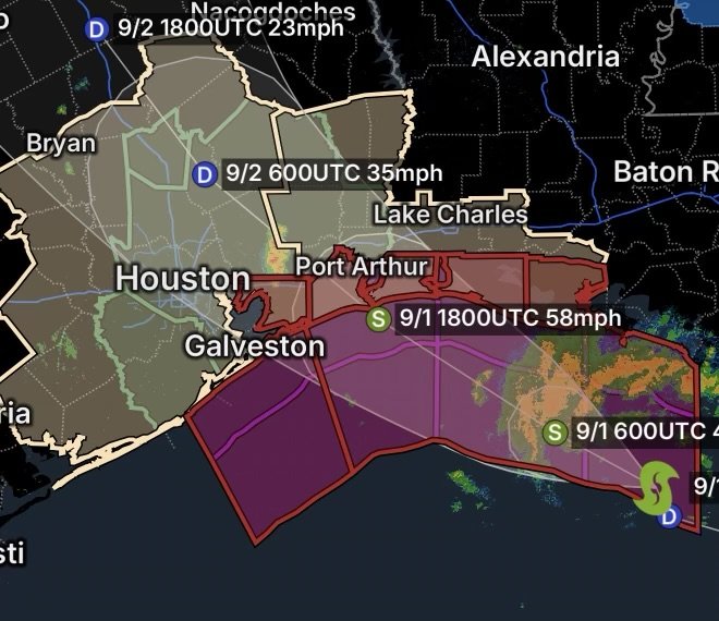
Tropical Storm Edouard has formed over the northern Gulf of Mexico and is moving toward the Texas-Louisiana coast. As of the 7:00 p.m. CDT advisory Monday, August 31, 2026, Edouard was located approximately 140 miles southeast of Cameron, Louisiana, and 175 miles southeast of Port Arthur, Texas. Maximum sustained winds were 40 mph, with higher gusts, while the storm was moving west-northwest at about 6 mph.
The National Hurricane Center says additional strengthening is expected before the center reaches the northwest Gulf Coast Tuesday.
Tropical Storm Warning Covers Gulf Coast
A Tropical Storm Warning is in effect from Port Bolivar, Texas, eastward to the Vermilion/Iberia Parish Line in Louisiana. Tropical storm conditions could begin affecting portions of the warning area Tuesday.
A Storm Surge Watch is also in effect from High Island, Texas, eastward to the Vermilion-Cameron Parish line in Louisiana.
Residents within the warning and watch areas should complete preparations now rather than waiting until conditions deteriorate.
Heavy Rain and Flash Flooding Are Major Concerns
While Edouard is not currently a hurricane, rainfall and flooding could become the most significant hazards.
Forecast information indicates that portions of eastern Texas could receive several inches of rain, with locally higher totals possible. Southwest Louisiana could also experience periods of heavy rainfall.
Heavy tropical rainfall can overwhelm drainage systems quickly, particularly in:
- Low-lying neighborhoods
- Urban areas
- Areas with poor drainage
- Locations near bayous, rivers and waterways
- Roads prone to flooding
Because tropical rainbands can produce intense rainfall in a short period, conditions may change rapidly even outside the immediate storm center.
Why Flooding Can Become Dangerous
Tropical systems transport large amounts of moisture from warm Gulf waters. As rainbands move across land, rainfall can fall faster than soil and drainage systems can absorb or carry it away.
That means a location that initially appears to be experiencing ordinary rain can transition into a dangerous flash-flood situation.
Never drive through a flooded roadway. Water depth can be difficult to judge, and moving water can sweep vehicles away.
Storm Surge Threat Along the Coast
Coastal communities also need to monitor the potential for storm surge and coastal flooding.
The National Hurricane Center’s current surge watch covers the area from High Island, Texas, toward the Vermilion-Cameron Parish area of Louisiana.
The greatest coastal water impacts will depend on Edouard’s exact track, strength, wind direction and timing relative to the tide.
Residents in vulnerable coastal locations should follow evacuation or emergency instructions from local officials.
Wind Impacts From Edouard
Edouard currently has maximum sustained winds of 40 mph, meeting the threshold for tropical-storm strength.
However, tropical-storm-force gusts can still cause problems, particularly when combined with saturated ground.
Potential impacts include:
- Downed tree limbs
- Scattered power outages
- Difficult driving conditions
- Dangerous conditions for boats and smaller vessels
- Loose outdoor objects becoming airborne
- Localized structural damage
Residents should secure outdoor furniture, decorations, trash cans and other loose items before stronger winds arrive.
Texas and Louisiana Communities Should Prepare Tonight
With Edouard approaching the coast Tuesday, residents across the warning area have a limited preparation window.
Before Conditions Worsen
Residents should:
- Monitor official weather alerts throughout the night.
- Charge phones and backup batteries.
- Secure loose outdoor objects.
- Avoid unnecessary travel once heavy rain and strong winds begin.
- Know whether your property is vulnerable to coastal or freshwater flooding.
- Keep medications, important documents and emergency supplies accessible.
- Never drive through flooded roads.
- Follow local evacuation orders immediately.
Radar Watch HQ Final Thoughts
Tropical Storm Edouard is a rapidly developing Gulf Coast threat, even though it is not expected to become a major hurricane. The storm’s proximity to land means there is little time for preparation, while heavy rainfall, flash flooding, coastal flooding and gusty winds could create dangerous conditions across portions of Texas and Louisiana.
At approximately 140 miles southeast of Cameron, Louisiana, Edouard is already close enough that residents should be preparing for deteriorating weather rather than waiting for the storm to arrive.
Stay weather-aware, keep emergency supplies ready and rely on official updates from the National Hurricane Center and local National Weather Service offices as Edouard approaches the coast.
This article reflects conditions and forecasts available as of August 31, 2026. Storm tracks and warnings can change quickly.