

















Strong Thunderstorms Could Create Dangerous Boating Conditions
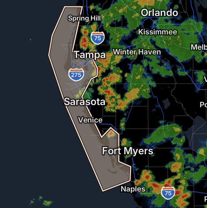
A Marine Weather Statement is highlighting the potential for strong thunderstorms across portions of Florida’s west coast and Gulf waters on Monday, August 31, 2026. Areas of concern include Charlotte Harbor and Pine Island Sound, Tampa Bay, and coastal waters extending from Bonita Beach northward toward the Suwannee River.
The latest National Weather Service coastal forecast calls for scattered showers and thunderstorms this afternoon, with winds and waves becoming higher in and near thunderstorms. (National Weather Service)
For boaters, the primary concerns are sudden gusty winds, lightning, heavy downpours, reduced visibility and rapidly changing water conditions.
Areas Covered by the Marine Weather Statement
The marine areas of concern include:
- Charlotte Harbor and Pine Island Sound
- Coastal waters from Bonita Beach to Englewood, Florida, out 20 NM
- Coastal waters from Englewood to Tarpon Springs, Florida, out 20 NM
- Coastal waters from Tarpon Springs to the Suwannee River, Florida, out 20 NM
- Tampa Bay waters
These waters cover a large section of Florida’s Gulf Coast, including heavily traveled recreational boating and fishing areas.
Why Thunderstorms Are the Main Marine Hazard
Thunderstorms can rapidly transform otherwise manageable boating conditions into hazardous situations.
Recent marine statements from the National Weather Service Tampa Bay office have documented strong thunderstorms capable of producing wind gusts around 30 knots, locally higher waves and frequent lightning. (National Weather Service)
In stronger storms, conditions can become even more dangerous. A recent Special Marine Warning in the region reported wind gusts exceeding 34 knots, suddenly higher waves, frequent lightning and heavy downpours. (National Weather Service)
Because thunderstorms can intensify quickly, boaters should not rely solely on conditions immediately around their departure point.
Charlotte Harbor and Pine Island Sound
Charlotte Harbor and Pine Island Sound can experience rapidly changing conditions when thunderstorms move across southwest Florida.
The current coastal forecast calls for isolated thunderstorms late this morning followed by scattered thunderstorms this afternoon. Winds are expected to remain relatively light outside of storms, but significantly stronger winds can develop near thunderstorms. (National Weather Service)
Boaters around Fort Myers, Sanibel, Captiva, Pine Island, Boca Grande and surrounding waters should keep weather information readily available and watch the sky for approaching storms.
Lightning Is a Major Threat
Lightning is especially dangerous on open water because boats provide little protection from a nearby thunderstorm.
If thunder is audible, lightning is close enough to pose a danger. The safest option is to reach a secure harbor before storms arrive.
Bonita Beach to Englewood
The coastal waters from Bonita Beach to Englewood out 20 nautical miles are also expected to experience scattered showers and thunderstorms this afternoon.
The latest forecast indicates seas generally 1 foot or less outside thunderstorms, with light winds. However, the National Weather Service emphasizes that winds and seas can become higher in and near thunderstorms. (National Weather Service)
That distinction is important: relatively calm forecast conditions do not mean the water will remain calm when a thunderstorm moves overhead.
Englewood to Tarpon Springs
Farther north, the Englewood to Tarpon Springs coastal waters out 20 NM are also under a stormy weather pattern.
The forecast calls for isolated showers and thunderstorms during the morning, followed by scattered showers and thunderstorms during the afternoon. (National Weather Service)
Storms moving across this area can produce:
- Sudden wind gusts
- Heavy rainfall
- Frequent lightning
- Rapid visibility reductions
- Choppy or locally rougher water
- Dangerous conditions for smaller vessels
Tarpon Springs to the Suwannee River
The northern portion of the coverage area extends from Tarpon Springs to the Suwannee River out 20 NM.
While conditions outside thunderstorms may remain relatively manageable, mariners should continue monitoring radar and marine updates because thunderstorm-generated winds and waves can be substantially stronger than the surrounding forecast.
Tampa Bay Waters
Tampa Bay is another important area to monitor as thunderstorms develop and move across west-central Florida.
Storms affecting the bay can create sudden changes in wind direction and speed. Heavy rainfall can also dramatically reduce visibility for boaters.
Recent National Weather Service warnings have included Tampa Bay waters when strong thunderstorms were producing wind gusts of 34 knots or greater. (National Weather Service)
Boating Safety: Know When to Head Back
The safest strategy is to avoid being caught on open water when thunderstorms approach.
Before Leaving the Dock
Check the latest:
- Marine weather forecast
- Radar
- Marine warnings and statements
- Lightning activity
- Wind and wave conditions
Also make sure everyone aboard has a properly fitted life jacket.
If a Thunderstorm Approaches
If you are already on the water and storms are moving toward your location, begin heading toward a safe harbor as early as possible.
Do not wait until lightning, strong winds or heavy rain are directly overhead.
If caught on open water, follow your vessel’s emergency procedures, stay away from unnecessary exposure to metal surfaces and seek the safest available shelter.
Radar Watch HQ Weather Reminder
The biggest concern today is not necessarily the background wind or wave forecast—it is the rapid weather changes associated with thunderstorms.
The National Weather Service specifically notes that marine forecasts should be monitored routinely because conditions can change, and winds and seas near thunderstorms may be higher than forecast. (National Weather Service)
For anyone planning to travel through the Gulf waters from Charlotte Harbor and Pine Island Sound to Tampa Bay and north toward the Suwannee River, keeping a close eye on developing thunderstorms is essential.
Radar Watch HQ Final Thoughts
A seemingly calm Gulf morning can quickly become dangerous when thunderstorms develop. Lightning, sudden wind gusts, heavy rain and rapidly changing waves can create serious hazards for boaters, especially smaller vessels.
If thunderstorms are approaching your location, the safest decision is to get off the open water and into a safe harbor before conditions deteriorate.
Stay weather-aware, monitor updated marine information and never underestimate the speed at which Florida Gulf Coast thunderstorms can intensify.
Stay alert. Stay prepared. Stay weather-aware with Radar Watch HQ.

Radar Watch HQ Top 5 Marine Essentials
Affiliate Disclosure: As an Amazon Associate, Radar Watch HQ earns from qualifying purchases.
🌊 1. U.S. Coast Guard-Approved Life Jacket
A properly fitted life jacket is the most important piece of safety equipment for every passenger onboard.
Best for: Recreational boaters, anglers, kayakers, and paddleboarders.
⚓ 2. Marine Emergency Radio (NOAA Weather Radio)
Receive real-time NOAA Weather Radio alerts, marine forecasts, and emergency warnings—even when cell service is unavailable.
Best for: Offshore and coastal boating.
🔦 3. Rechargeable Waterproof LED Flashlight
A bright waterproof flashlight is essential for emergencies, low visibility, nighttime navigation, and signaling for help.
Best for: Every boat emergency kit.
🧰 4. Marine First Aid Kit
A waterproof first aid kit stocked with bandages, antiseptic, medications, and emergency supplies for injuries on the water.
Best for: Every vessel, regardless of size.
🧭 5. Waterproof Dry Bag
Protect phones, wallets, charts, keys, electronics, and emergency supplies from water damage during storms or rough seas.
Best for: Boaters, kayakers, paddleboarders, and beachgoers.
🛒 Radar Watch HQ Marine Safety Picks
Prepare before you head out on the water. Our recommended marine safety essentials can help keep you and your crew safe during changing weather conditions.