

















Southeast Texas flooding
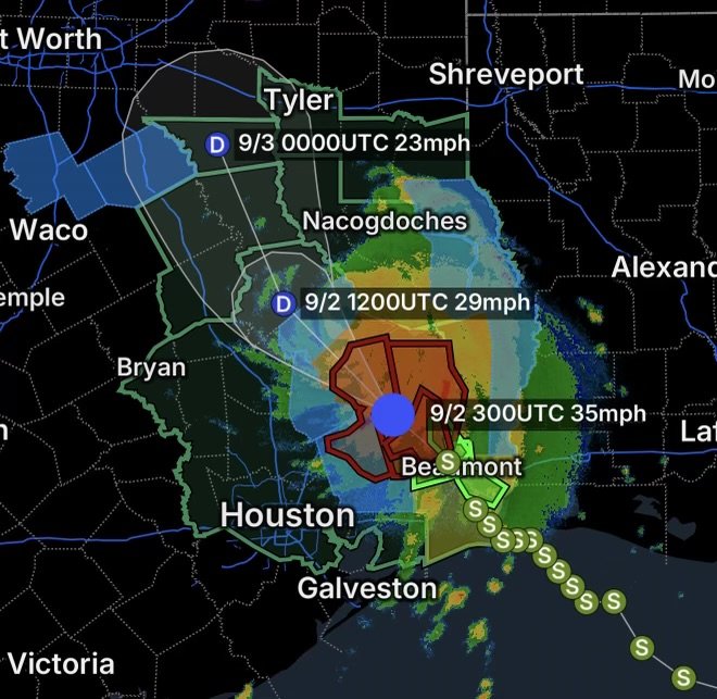
Southeast Texas is facing a significant flooding and power outage threat as Tropical Depression Edouard continues moving inland. Although Edouard has weakened from a tropical storm, the system is still producing torrential rainfall, flash flooding, strong winds and hazardous travel conditions across the region.
Parts of the region have already received exceptionally heavy rainfall, with some locations northwest of Beaumont reporting totals approaching 21 inches. Additional heavy rain is possible as the tropical system gradually weakens.
Tropical Depression Edouard Keeps Southeast Texas on Alert
Edouard made landfall near the Texas-Louisiana border on Tuesday with maximum sustained winds near 60 mph before weakening into a tropical depression. Despite the loss of tropical-storm strength, the circulation continues to transport deep tropical moisture into Southeast Texas.
That moisture is supporting periods of extremely heavy rainfall. Because soils and drainage systems can become overwhelmed quickly, flooding may continue even after the strongest winds diminish.
Flash Flood Warning for Northern Liberty County and Polk County
A Flash Flood Warning is affecting Northern Liberty County in southeastern Texas and Polk County in southeastern Texas.
Residents in these areas should take rapidly rising water seriously. Flash flooding can develop quickly, particularly near creeks, streams, low-water crossings and poorly drained roadways.
Never drive through flooded roads. Water can conceal washed-out pavement, debris or damaged bridges, while relatively shallow moving water can sweep vehicles away.
Flood Watch Covers a Large Portion of Southeast Texas
A broad Flood Watch remains in effect for portions of Southeast Texas, including:
- Brazos County
- Chambers County
- Coastal Harris County
- Grimes County
- Houston County
- Inland Harris County
- Madison County
- Montgomery County
- Northern Liberty County
- Polk County
- San Jacinto County
- Southern Liberty County
- Trinity County
- Walker County
- Waller County
The widespread coverage highlights how extensive the moisture plume associated with Edouard has become.
Additional rainfall could worsen existing flooding, create new flash-flooding problems and cause rivers and smaller waterways to rise.
Neches River Flooding Adds Another Concern
A Flood Warning is also in effect for the Neches River at the Neches River Saltwater Barrier.
River flooding can remain a concern after the heaviest thunderstorms move away. Water levels can continue rising as rainfall from upstream areas flows downstream.
Residents near the river should monitor water levels and local emergency information and be prepared to move to higher ground if conditions worsen.
Polk County and Orange County Power Outages
Power outages are also part of the ongoing Southeast Texas weather emergency.
Polk County is experiencing power outages, while Orange County is also reporting outages associated with the storm’s impacts.
Strong winds, saturated ground and falling trees can damage power lines and electrical infrastructure. Crews may face difficult conditions while attempting to restore service, particularly where roads are flooded or blocked by debris.
Across Southeast Texas, tens of thousands of utility customers have experienced outages during Edouard’s impacts.
What to Do During a Power Outage
If your electricity goes out:
- Use flashlights instead of candles whenever possible.
- Keep refrigerators and freezers closed to preserve food.
- Unplug sensitive electronics to protect them from power surges.
- Stay away from downed power lines.
- Never use a generator indoors, inside a garage or near doors and windows.
- If flooding is occurring, avoid electrical equipment that may have been exposed to water.
Why Southeast Texas Is Seeing Such Heavy Rain
Tropical systems are efficient rainfall producers because they carry enormous amounts of warm, humid air.
As Edouard moved inland, its circulation continued drawing Gulf moisture into Southeast Texas. Bands of thunderstorms can repeatedly move across the same locations, producing rainfall faster than the ground and drainage systems can absorb it.
This training effect can dramatically increase localized rainfall totals and create dangerous flash-flood conditions.
Roads Could Become Dangerous Quickly
Flooding remains one of the greatest hazards from the remnants of Edouard.
Drivers should avoid flooded roadways, barricades and low-water crossings. If water is covering a road, Turn Around, Don’t Drown.
Even if a road appears passable, floodwater can hide dangerous conditions underneath.
Residents should also expect possible delays from:
- Flooded streets
- Downed trees
- Debris
- Damaged traffic signals
- Power outages
- Road closures
- Rising rivers and creeks
Southeast Texas Flooding: What Residents Should Watch Next
The greatest concern now is not necessarily tropical-storm wind strength, but continued rainfall and flooding.
Some areas have already received extraordinary amounts of rain, meaning additional precipitation could quickly worsen conditions. The Houston area and surrounding communities should continue monitoring local warnings as Edouard’s remnants move farther inland.
Residents should keep phones charged, monitor emergency notifications and have a way to receive weather information if electricity or internet service becomes unavailable.
Radar Watch HQ Final Thoughts
Tropical Depression Edouard may be weakening, but the flood threat across Southeast Texas remains serious. Flash Flood Warnings in Northern Liberty County and Polk County, a broad Flood Watch, Neches River flooding and power outages in Polk and Orange Counties demonstrate that dangerous conditions can continue well after a tropical system loses its named-storm strength.
The most important message is simple: Do not underestimate a weakening tropical depression. Heavy rainfall and flooding can remain life-threatening long after the winds decrease.
If flooding is occurring in your area, move to higher ground when necessary, avoid flooded roads and follow instructions from local emergency officials.
Stay weather-aware. Stay safe.

Affiliate Disclosure: As an Amazon Associate, Radar Watch HQ earns from qualifying purchases.
Radar Watch HQ Top 5 Essential Emergency Preparedness Picks
Whether you’re preparing for severe thunderstorms, flash flooding, hurricanes, wildfires, or extended power outages, these five emergency essentials can help keep your household safer when severe weather strikes.
A portable power station provides reliable backup electricity during outages, allowing you to power phones, medical devices, laptops, lights, small appliances, and communication equipment without fuel.
Best for:
- Extended power outages
- Severe thunderstorms
- Hurricanes
- Winter storms
- Wildfires
2. Flood Protection Barriers & Sandless Flood Bags
Flood barriers help divert or absorb water before it enters garages, doorways, and low-lying areas. They deploy quickly and can help reduce property damage during flash flooding.
Best for:
- Flash Flood Warnings
- Heavy rainfall
- River flooding
- Coastal flooding
3. Rechargeable LED Flashlights
Bright, dependable flashlights are essential when the power goes out. Rechargeable or solar-powered models provide long-lasting illumination for navigating safely indoors and outdoors.
Best for:
- Overnight power outages
- Emergency evacuations
- Storm damage inspections
Keep phones, tablets, weather radios, and USB-powered devices charged when the electrical grid is unavailable. A solar power bank offers an additional charging option during prolonged emergencies.
Best for:
- Communication during outages
- Emergency weather alerts
- Travel and evacuation
A NOAA Weather Radio delivers official weather alerts directly from the National Weather Service, even when cellular networks or internet service are unavailable. It remains one of the most dependable ways to receive life-saving warnings.
Best for:
- Tornado warnings
- Severe thunderstorm warnings
- Flash flood warnings
- Hurricane alerts
- Winter storm emergencies
Why Radar Watch HQ Recommends These Essentials
At Radar Watch HQ, preparedness is just as important as staying informed. These five emergency essentials can help you stay connected, protect your property, and safely navigate severe weather events. Having supplies ready before storms arrive allows you to respond quickly when warnings are issued and conditions begin to deteriorate.