Hurricane Lowell Hawaii Flood Threat
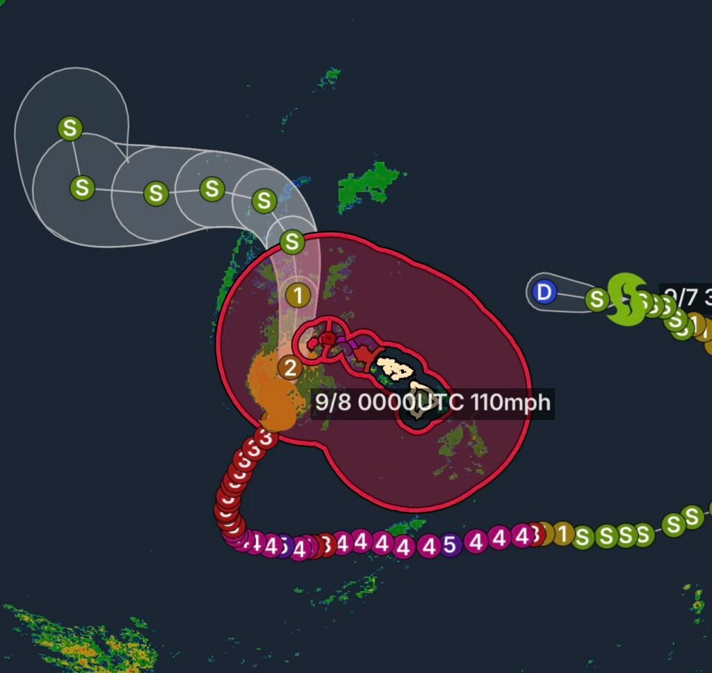
Hawaii is facing a significant tropical weather threat today as Category 2 Hurricane Lowell approaches the western Hawaiian Islands. The National Weather Service says hurricane conditions are expected across portions of the Hawaiian offshore waters, while heavy rain, dangerous surf and flooding concerns continue across the main islands.
At the same time, Post-Tropical Cyclone Karina remains part of the broader Pacific weather picture but is no longer the primary threat to Hawaii. The current concern for the islands is Hurricane Lowell and the large area of tropical moisture surrounding the storm.
Hurricane Lowell Brings Dangerous Conditions Near Hawaii
Hurricane Lowell is moving north-northeast toward the Hawaiian Islands, with the strongest impacts expected near Kauai and Niihau. The National Weather Service reports that hurricane conditions are expected in the western offshore waters tonight into Tuesday.
A Hurricane Warning means residents and mariners should not wait for conditions to deteriorate before taking protective action.
For coastal communities, the threat extends beyond wind. Large and dangerous waves, strong currents, coastal flooding and rapidly changing ocean conditions can make beaches and exposed shorelines extremely hazardous.
High surf is already a significant concern, with warning-level surf affecting south-facing shores and additional dangerous surf expected along portions of the Big Island.
Flood Watch Covers Oahu, Maui County and the Big Island
One of the biggest statewide concerns is heavy rainfall.
The Flood Watch remains in effect through Tuesday afternoon for Oahu, Maui County and the Big Island. Forecasters say moisture on the eastern side of Hurricane Lowell will produce periods of heavy rain across the main Hawaiian Islands.
Oahu
Oahu could experience periods of heavy rain, particularly as tropical moisture interacts with the island’s mountainous terrain.
Urban areas can experience rapid runoff, while normally manageable streams and drainage channels can rise quickly. Flood-prone roads may become impassable.
Maui County
Maui County is also vulnerable to heavy showers and thunderstorms. Mountain and windward areas can see enhanced rainfall, while runoff may spread flooding concerns into lower elevations.
Residents should avoid driving through water-covered roads. Even relatively shallow moving water can conceal damaged pavement, debris or washed-out sections of roadway.
Big Island
The Big Island faces a broad range of weather hazards because of its size and varied terrain. Heavy rainfall may affect windward and mountainous areas before spreading into additional portions of the island.
Flooding is possible along streams, drainage areas and low-lying roads, while thunderstorms could produce locally intense rainfall.
The National Weather Service specifically warns that flood-prone roads and low-lying areas may close because of elevated runoff and overflowing streams.
Post-Tropical Cyclone Karina
Post-Tropical Cyclone Karina is a separate system from Hurricane Lowell.
Karina previously became a powerful hurricane over the eastern Pacific, but it has since transitioned into a post-tropical system. The latest Hawaiian offshore forecast indicates that Karina remains northeast of the Hawaiian offshore waters and is expected to dissipate.
However, the storm’s legacy can still influence Hawaiian conditions. The National Weather Service notes that a large swell associated with former Tropical Storm Karina is contributing to elevated surf along east-facing shores.
This illustrates an important point about tropical systems: a storm does not have to be a hurricane or even tropical to continue producing hazardous ocean conditions.
Tropical Cyclone Statement: Why Residents Should Keep Watching
A Tropical Cyclone Statement for the Hawaiian Islands reflects the evolving tropical threat and the need for residents to continue monitoring official forecasts.
Conditions can change quickly when a tropical cyclone approaches the islands. Small changes in track, size or intensity can shift the areas experiencing the strongest winds, heaviest rain or highest surf.
The National Weather Service currently expects Lowell to pass west of Kauai, but close enough to produce significant impacts.
Hurricane Safety: What Residents Should Do Now
If you are in an affected Hawaiian community:
- Stay away from beaches, rocky shorelines and exposed coastal areas.
- Never drive through flooded roads.
- Move to higher ground if flooding threatens your location.
- Secure loose outdoor objects before winds increase.
- Keep phones, weather radios and emergency alerts available.
- Follow evacuation or emergency-management instructions immediately.
- Do not rely on the storm’s center passing directly overhead to determine whether conditions are dangerous.
- Continue monitoring official forecasts through Tuesday.
Flooding can become especially dangerous after dark because water depth and road damage are harder to see.
Why the Flood Threat May Continue After the Storm’s Closest Approach
Hawaii’s mountainous terrain can dramatically enhance rainfall from tropical moisture.
As moist air encounters the islands’ mountains, it is forced upward. Rising air cools, condensation increases and heavy showers or thunderstorms can develop. Consequently, flooding may occur even when the hurricane’s center remains offshore.
The National Weather Service expects flooding potential to continue through Tuesday as Lowell’s moisture interacts with the Hawaiian Islands.
Radar Watch HQ Final Thoughts
Hawaii’s current weather threat is a multi-hazard event, not simply a hurricane wind situation.
Hurricane Lowell is the primary tropical threat, with hurricane conditions possible over portions of the offshore waters and dangerous surf affecting multiple shorelines. At the same time, Oahu, Maui County and the Big Island remain under a Flood Watch through Tuesday afternoon, making heavy rain and flash flooding major concerns.
Meanwhile, Post-Tropical Cyclone Karina is weakening away from the islands, although its remaining swell is still contributing to hazardous ocean conditions.
Residents should continue monitoring official warnings and forecasts, avoid flooded roadways and stay away from dangerous surf until conditions improve.
Stay weather-aware, stay prepared, and never underestimate rapidly changing tropical conditions.
Affiliate Disclosure: As an Amazon Associate, Radar Watch HQ earns from qualifying purchases.
Radar Watch HQ Top 5 Essential Emergency Preparedness Picks
Whether you’re preparing for severe thunderstorms, flash flooding, hurricanes, wildfires, or extended power outages, these five emergency essentials can help keep your household safer when severe weather strikes.
A portable power station provides reliable backup electricity during outages, allowing you to power phones, medical devices, laptops, lights, small appliances, and communication equipment without fuel.
Best for:
- Extended power outages
- Severe thunderstorms
- Hurricanes
- Winter storms
- Wildfires
2. Flood Protection Barriers & Sandless Flood Bags
Flood barriers help divert or absorb water before it enters garages, doorways, and low-lying areas. They deploy quickly and can help reduce property damage during flash flooding.
Best for:
- Flash Flood Warnings
- Heavy rainfall
- River flooding
- Coastal flooding
3. Rechargeable LED Flashlights
Bright, dependable flashlights are essential when the power goes out. Rechargeable or solar-powered models provide long-lasting illumination for navigating safely indoors and outdoors.
Best for:
- Overnight power outages
- Emergency evacuations
- Storm damage inspections
Keep phones, tablets, weather radios, and USB-powered devices charged when the electrical grid is unavailable. A solar power bank offers an additional charging option during prolonged emergencies.
Best for:
- Communication during outages
- Emergency weather alerts
- Travel and evacuation
A NOAA Weather Radio delivers official weather alerts directly from the National Weather Service, even when cellular networks or internet service are unavailable. It remains one of the most dependable ways to receive life-saving warnings.
Best for:
- Tornado warnings
- Severe thunderstorm warnings
- Flash flood warnings
- Hurricane alerts
- Winter storm emergencies
Why Radar Watch HQ Recommends These Essentials
At Radar Watch HQ, preparedness is just as important as staying informed. These five emergency essentials can help you stay connected, protect your property, and safely navigate severe weather events. Having supplies ready before storms arrive allows you to respond quickly when warnings are issued and conditions begin to deteriorate.