Severe thunderstorms and flooding concerns put parts of Iowa, Nebraska, Missouri and Kansas on alert
A significant round of severe weather and heavy rainfall is developing across parts of the central Plains and Midwest, with multiple National Weather Service alerts in effect Monday, September 14. Communities across Iowa, Nebraska, Missouri and Kansas are facing a combination of severe thunderstorm, tornado and flooding concerns.
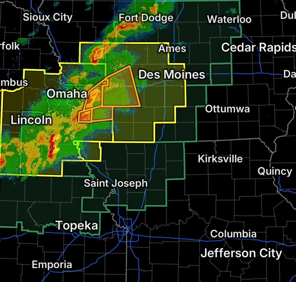
The greatest immediate concern is across western Iowa, where a Severe Thunderstorm Warning is in effect for parts of Cass, Guthrie, Audubon and Adair counties. At the same time, a broader Tornado Watch covers portions of western into central Iowa, far northwestern Missouri and eastern Nebraska.
Residents should remain weather-aware as storms develop and move through the region. Severe thunderstorms can intensify quickly, producing damaging winds, large hail and frequent lightning, while the tornado threat means residents should be prepared to move indoors immediately if a warning is issued for their location.
Severe Thunderstorm Warning — Western Iowa
A Severe Thunderstorm Warning is affecting:
- Cass County, Iowa
- Western Guthrie County, Iowa
- Southern Audubon County, Iowa
- Adair County, Iowa
Strong thunderstorms in this area can produce damaging wind gusts, large hail, intense rainfall and dangerous lightning. Storms may also create rapidly changing conditions on roadways.
People in the warned area should move indoors and remain away from windows. Outdoor activities should be postponed until the storm has passed.
Tornado Watch Covers a Large Portion of the Region
A Tornado Watch is in effect for portions of western into central Iowa, far northwestern Missouri and eastern Nebraska.
A watch means conditions are favorable for tornadoes and severe thunderstorms. It does not mean that a tornado is occurring at every location inside the watch area.
However, residents should have a way to receive weather warnings immediately and know where they will shelter if a Tornado Warning is issued.
The safest option during a tornado warning is a sturdy building. Move to a basement when available, or to a small interior room on the lowest floor away from windows. Protect your head and neck with your arms or other available protective materials.
Flood Watch Continues Across Iowa
Heavy rainfall is also creating a flooding concern across portions of southwestern, central and northeastern Iowa.
A Flood Watch means conditions are favorable for flooding, including the possibility of excessive rainfall overwhelming drainage systems, creeks and low-lying areas.
Repeated thunderstorms moving over the same areas can increase the potential for rapid water accumulation. Even locations that do not experience severe winds or hail may still face dangerous flooding.
Drivers should never attempt to cross a flooded roadway. Water depth can be difficult to judge, and road surfaces may be damaged or washed out underneath the water.
Flood Watch Expands Across North-Central and Northeast Kansas
Flooding is also a concern across portions of north-central and northeastern Kansas. The Flood Watch includes:
Clay County, Washington County, Brown County, Jackson County, Jefferson County, Marshall County, Nemaha County, Pottawatomie County and Riley County.
Periods of heavy rain and thunderstorms could result in rising water levels, ponding on roadways and localized flooding.
Residents in flood-prone locations should monitor changing conditions and be prepared to move to higher ground if flooding becomes dangerous.
Why This Weather Setup Matters
The combination of thunderstorms and heavy rainfall creates two separate hazards that can occur at the same time.
Some storms may become strong enough to produce damaging winds and hail, while other storms or repeated rounds of rainfall may produce flooding. Where atmospheric conditions become favorable for rotating storms, the tornado threat can increase as well.
The National Weather Service is currently highlighting heavy to excessive rainfall across portions of the central Plains and Midwest, along with the potential for strong to severe thunderstorms from eastern Nebraska into western Iowa. (National Weather Service)
What Residents Should Do Now
If you are located within or near the affected areas:
- Keep weather alerts enabled on your phone.
- Monitor local National Weather Service updates.
- Know where to shelter before storms intensify.
- Move indoors immediately when a Severe Thunderstorm or Tornado Warning is issued.
- Stay away from windows during severe storms.
- Avoid flooded roads and never drive through moving water.
- Bring outdoor objects inside or secure them if severe storms are approaching.
- Do not rely solely on outdoor warning sirens; they may not be audible indoors or in noisy environments.
Weather conditions can change quickly this afternoon and evening. Residents across the affected portions of Iowa, Nebraska, Missouri and Kansas should continue monitoring official weather information and be prepared to act if warnings are issued for their location.
Stay weather-aware, know your shelter location, and take every warning seriously as storms and heavy rainfall move across the region.