Flood Threat Continues Across the Southwest
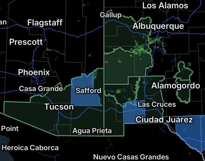
A broad flood threat is developing across portions of southeastern Arizona and southern New Mexico, with Flood Watches covering areas where repeated thunderstorms and locally heavy rainfall could produce flooding.
The Tucson Metro Area is included in the Flood Watch for Southeast Arizona. Recent storms around the Tucson area have already produced significant rainfall, including multiple flash flood warnings across Pima County.
A Flood Watch means flooding is possible, but it does not mean flooding is occurring everywhere within the watch area. Residents should continue monitoring changing weather conditions and be prepared to act if a Flash Flood Warning is issued.
Tucson Metro Area and Southeast Arizona
The Tucson region remains vulnerable to rapid runoff when thunderstorms develop over the mountains and move across populated areas.
Urban areas can experience flooding quickly because pavement and other developed surfaces prevent rainfall from soaking into the ground. Low-water crossings, washes, drainage channels and normally dry creek beds can become dangerous with little warning.
Recent heavy thunderstorms in eastern and northeastern Pima County demonstrate how quickly conditions can deteriorate when intense rainfall develops.
Residents in the Tucson Metro Area should avoid entering flooded roadways and should never drive around barricades. Even shallow moving water can make a vehicle difficult or impossible to control.
Graham County Power Outages
Power outages are also being reported in Graham County, Arizona, adding another concern as unsettled weather continues across the region.
Strong thunderstorms can bring lightning, gusty winds and heavy rainfall capable of affecting electrical infrastructure. Graham County Electric Cooperative maintains outage reporting and storm information for customers in its service area.
During an outage, residents should use flashlights instead of candles when possible, keep refrigerators and freezers closed, and stay away from downed power lines. If power lines have fallen, assume they are energized and keep a safe distance.
Flood Watch Expands Across New Mexico
Flood Watches are also covering portions of south central and southwest New Mexico.
The watch includes portions of the Southwest Mountains, San Francisco River Valley, San Agustin Plains and adjacent lowlands. These areas include mountainous terrain as well as valleys and low-lying locations where heavy rainfall can produce rapid runoff.
The National Weather Service is highlighting the potential for heavy to excessive rainfall across southern Arizona and New Mexico this week.
Mountain thunderstorms can be particularly dangerous because rainfall occurring upstream can send water rapidly into valleys and drainage areas, even when conditions at a person’s immediate location do not appear especially threatening.
Luna County Power Outages
Luna County, New Mexico, is also experiencing reported power outages.
Power outage tracking data shows outages affecting customers in the county, although outage numbers can change quickly as crews restore service and additional outages occur.
Residents experiencing an outage should monitor their local utility for restoration information and prepare for the possibility that severe weather could delay repairs.
If thunderstorms are occurring nearby, avoid unnecessary travel, especially on roads that cross washes or other low-water areas.
Why Flooding Can Develop So Quickly
The Southwest’s terrain can make flooding particularly dangerous.
Thunderstorms may develop over higher elevations and produce intense rainfall over a relatively small area. Water then moves downhill through washes, arroyos and drainage channels. This can cause flooding well away from where the heaviest rain originally fell.
A location can therefore experience dangerous flooding even when rainfall at that exact location has been limited.
This is one reason a Flood Watch should be taken seriously before flooding begins. Conditions can change quickly once thunderstorms become organized or repeatedly move over the same area.
Safety Remains the Priority
If a Flash Flood Warning is issued for your location:
- Move to higher ground immediately if flooding is occurring or approaching.
- Never drive through a flooded roadway.
- Do not walk or drive through moving water.
- Stay away from washes, arroyos, normally dry creek beds and low-water crossings.
- Follow instructions from local emergency officials.
- If you encounter a barricaded or closed roadway, turn around and find another route.
- During a power outage, stay away from downed or damaged electrical lines.
Flood Watches are designed to provide time to prepare before dangerous flooding develops. With thunderstorms capable of producing heavy rainfall across portions of Arizona and New Mexico, residents should continue monitoring official weather information throughout the day.
Radar Watch HQ will continue tracking the evolving flood and severe-weather situation across the Southwest. Stay weather aware, know your safest route to higher ground, and never risk your life trying to cross floodwater.