Dangerous Marine Conditions Developing Along the Pacific Northwest Coast
Mariners along the southern Oregon and northern California coastline are facing increasingly dangerous conditions as strong winds and rapidly building seas develop across several offshore zones on September 24, 2026.
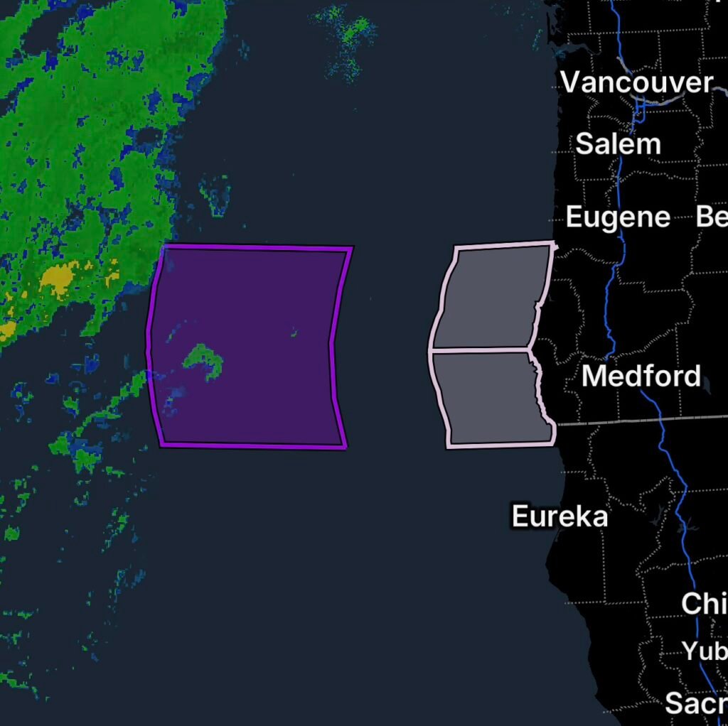
The National Weather Service marine forecast identifies hazardous conditions from Cape Blanco, Oregon, to Point St. George, California, extending from the nearshore waters to 60 nautical miles offshore. Farther west, a Storm Warning covers the waters from Florence, Oregon, to Point St. George between 150 and 250 nautical miles offshore.
These warnings cover different marine zones, meaning conditions can vary significantly depending on how far a vessel is from the coast.
Hazardous Seas From Cape Blanco to Point St. George
The coastal waters from Cape Blanco, Oregon, to Point St. George, California, including waters extending 10 to 60 nautical miles offshore, are expected to experience very steep and hazardous seas.
The National Weather Service forecast indicates seas of approximately 7 to 12 feet at around 10 seconds are possible during the hazardous period. Such closely spaced, steep waves can make navigation difficult and create dangerous conditions for smaller vessels.
The highest potential for the most hazardous seas is noted south of Cape Blanco, with particularly elevated chances north of Gold Beach.
Bar crossings can become especially dangerous when strong winds and steep waves combine. Mariners should carefully consider conditions before leaving port or attempting to cross coastal bars.
Storm Warning 150 to 250 Nautical Miles Offshore
The most significant marine threat is farther offshore.
A Storm Warning is in effect for waters from Florence, Oregon, to Point St. George, California, between 150 and 250 nautical miles offshore.
According to the offshore forecast, winds Thursday are expected to increase from 20 to 30 knots before becoming west to southwest at 35 to 45 knots. Seas are forecast to build from 6 to 10 feet to 10 to 16 feet.
Conditions become even more severe Thursday night, when west to northwest winds are forecast at 40 to 50 knots, with seas reaching approximately 12 to 20 feet.
Individual waves can be considerably higher than the significant wave height reported in marine forecasts. The National Weather Service notes that significant wave height represents the average height of the highest one-third of waves.
What These Conditions Mean for Mariners
Strong winds and steep seas can create several serious hazards:
- Difficult and unstable vessel handling
- Reduced visibility during periods of rain
- Dangerous wave impacts and spray
- Increased risk of vessel damage
- Greater potential for capsizing, particularly for smaller vessels
- Dangerous coastal bar crossings
- Difficult search-and-rescue conditions if an emergency develops
The National Weather Service advises mariners to consider altering plans when very steep and hazardous seas are expected.
For vessels already offshore, crews should closely monitor updated marine forecasts, maintain reliable communications, secure equipment and cargo, and be prepared for rapidly deteriorating conditions.
Conditions Will Improve After the Peak
The strongest offshore conditions are expected Thursday into Thursday night. By Friday, winds are forecast to decrease, although seas will remain elevated.
For the 150-to-250-nautical-mile zone, Friday’s forecast calls for northwest winds around 15 to 25 knots, diminishing to 10 to 15 knots, with seas around 8 to 12 feet.
This means improving winds will not immediately eliminate the danger. Large residual swells can continue affecting vessels after the strongest winds move away.
Coastal Oregon and Northern California Need to Stay Weather-Aware
The marine warnings span a large portion of the Pacific waters between southern Oregon and northern California. Conditions farther offshore are expected to become substantially more dangerous than those immediately along the coast.
Anyone planning a fishing trip, recreational boating trip, commercial voyage, or offshore transit should check the latest National Weather Service marine forecasts and warnings before departure and continue monitoring updates while underway. The NWS provides coastal, offshore and high-seas marine forecasts and warning products for these waters.
Radar Watch HQ Final Thoughts
The combination of strong winds and steepening seas makes this an important period for marine safety from southern Oregon into northern California. The most severe conditions are expected well offshore, while hazardous seas closer to the coast can still create dangerous conditions, especially around exposed waters and coastal bar crossings.
Marine conditions can change quickly. Mariners should use the latest official NWS forecasts, heed active warnings, and avoid unnecessary exposure to dangerous seas.
Stay weather-aware, know your marine zone, and make safety the priority before heading offshore.