Flood-prone terrain, saturated ground, burn scars and urban areas face another round of heavy rain and thunderstorms
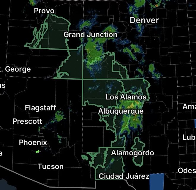
A widespread flood threat is developing across portions of Utah, Colorado and New Mexico on Thursday, September 17, 2026, as additional showers and thunderstorms move across the Southwest.
The National Weather Service has Flood Watches in effect for areas where repeated rainfall, saturated soils, steep terrain, burn scars, dry washes and poor drainage could allow water levels to rise quickly. Some storms could produce intense rainfall in a short period, increasing the potential for flash flooding. (National Weather Service)
For residents and visitors, a Flood Watch means conditions are favorable for flooding. It does not mean flooding will occur everywhere within the watch area, but people should remain prepared to act if a Flash Flood Warning is issued.
Utah Flood Watch
A Flood Watch continues across portions of central and eastern Utah, including:
- Castle Country
- Central Mountains
- San Rafael Swell
- Wasatch Plateau/Book Cliffs
The National Weather Service reports that excessive runoff could affect rivers, creeks, streams, normally dry washes, slot canyons, slickrock areas and other low-lying locations.
Showers and thunderstorms are expected to redevelop Thursday afternoon and continue into the evening. Rainfall rates around 0.25 to 1 inch per hour, with locally higher rates beneath stronger storms, could produce rapid runoff. (National Weather Service)
The combination of previous rainfall and additional storms is especially concerning in areas where the ground has become saturated. Slot canyons and normally dry washes can become dangerous quickly when heavy rain falls upstream.
Southwest Colorado Flood Watch
A Flood Watch is also in effect across portions of southwest Colorado, including:
- Animas River Basin
- Four Corners/Upper Dolores River
- Northwest San Juan Mountains
- San Juan River Basin
- Southwest San Juan Mountains
Communities and areas around Durango, Silverton, Telluride, Ouray, Cortez, Mancos, Dolores, Bayfield and Ignacio are among the locations within the broader watch area. (National Weather Service)
Recent heavy rainfall has already left portions of the region saturated. Additional rounds of showers and thunderstorms could produce periods of heavy rainfall and flash flooding.
The National Weather Service specifically notes concerns for steep terrain and burn scars, including the Gold Mountain, Elk and Ferris burn scars. (National Weather Service)
Mountain terrain can increase runoff and channel water into streams, creeks and drainage areas. Flooding may also occur in places that are normally dry.
New Mexico Flood Watch
New Mexico has several areas under Flood Watches as additional thunderstorms and heavy rainfall develop Thursday.
The threat extends across portions of central, north-central and northwest New Mexico, including:
- South Central Mountains
- Far Northwest Highlands
- Northwest Highlands
- Chuska Mountains
- Northwest Plateau
The National Weather Service says additional rounds of showers and thunderstorms are expected from Thursday afternoon into the overnight hours. Rainfall rates of 1 to 2 inches per hour may occur with stronger storms. (National Weather Service)
Recent rainfall has already increased soil moisture across parts of the region. Additional storms could therefore generate rapid runoff, particularly around streams, low-lying areas, burn scars and locations with limited drainage.
The watch includes areas around Farmington and Shiprock, while vulnerable burn-scar areas near Ruidoso are also a concern. (National Weather Service)
Albuquerque Metro Area
The Albuquerque area is also facing a period of unsettled weather with a Flood Watch in effect.
The National Weather Service forecast calls for scattered showers and thunderstorms, with the potential for heavier rainfall. The current Flood Watch for Albuquerque extends from Thursday morning into the early hours of Friday. (National Weather Service)
Urban areas can experience flooding more quickly because pavement and other surfaces prevent rainfall from soaking into the ground efficiently. Water can collect in streets, drainage channels, underpasses and other low-lying areas.
Drivers should be especially cautious if heavy rain develops during the afternoon or evening commute.
South-Central and Southwest New Mexico
Another Flood Watch covers portions of south-central and southwest New Mexico, including:
- Sierra County
- Doña Ana County
- Luna County
- Eastern Grant County
- Sacramento Mountains in northern Otero County
The current watch is scheduled from noon Thursday through 6 AM Friday morning. (National Weather Service)
The National Weather Service reports that portions of south-central New Mexico have already received roughly 1 to 2 inches of rainfall during the previous 24 hours. High soil moisture means additional rainfall may run off quickly. (National Weather Service)
Thunderstorms are expected to move north across the watch area Thursday night into Friday morning, creating localized flash-flood potential.
The Sacramento Mountains have an additional concern because storms could repeatedly move over the same locations. This type of storm development can produce prolonged heavy rainfall and increasing runoff.
The watch includes portions of the I-25 corridor near Hatch and Truth or Consequences and the I-10 corridor near Las Cruces and Deming. (National Weather Service)
Why Flash Flooding Can Develop So Quickly
Flash flooding does not require an entire region to receive widespread rainfall.
A slow-moving or repeatedly developing thunderstorm can dump a large amount of rain over a small area. Water can then move rapidly downhill through washes, arroyos, streams and drainage channels.
Several factors are increasing the concern across the Southwest:
Saturated ground: Previous rainfall has reduced the amount of water the soil can absorb.
Mountain terrain: Steep slopes can rapidly channel water into valleys and drainage areas.
Burn scars: Wildfire-damaged landscapes can produce extremely rapid runoff and debris flows during heavy rainfall.
Dry washes and arroyos: These channels can appear harmless when dry but become dangerous when water suddenly moves through them.
Slot canyons: Water from storms miles away can quickly enter narrow canyon systems.
Urban drainage: Heavy rain can overwhelm storm drains and produce rapidly rising water on streets and low-lying roads.
Flood Safety: What to Do
A Flood Watch is the time to prepare before flooding begins.
- Monitor weather updates and official alerts throughout the day.
- Have a reliable way to receive Flash Flood Warnings.
- Avoid entering slot canyons, washes and normally dry stream channels when storms are nearby.
- Never drive through water covering a roadway.
- Turn around if you encounter a flooded road.
- Be especially careful at night when floodwater can be difficult to see.
- Move to higher ground if water begins rising around your location.
- Follow instructions from local emergency management officials.
- If a Flash Flood Warning is issued for your location, take immediate action.
Remember that flooding can occur downstream from where the heaviest rain falls. A location may be dry while water is rapidly moving toward it from storms farther upstream.
What to Watch Through Thursday Night
The combination of moisture, mountainous terrain and repeated thunderstorms means flood conditions can change quickly across the watch areas.
Utah communities should watch normally dry washes, slot canyons, slickrock terrain and recent burn scars. Southwest Colorado residents and visitors should pay close attention to streams, steep terrain and burn scars across the San Juan region. New Mexico faces concerns ranging from the Albuquerque metropolitan area and northwest highlands to the Sacramento Mountains and communities along major travel corridors. (National Weather Service)
The National Weather Service advises residents in flood-prone locations to remain alert for possible Flash Flood Warnings and be prepared to take action if flooding develops. (National Weather Service)
Radar Watch HQ Final Thoughts
This is a situation where conditions can change faster than the weather may appear to change outside your window. A Flood Watch provides time to prepare before dangerous flooding develops.
Keep alerts enabled, know where higher ground is located, and avoid flooded roads and drainage channels. If a Flash Flood Warning is issued for your area, don’t wait for water to become dangerous before taking action.
Stay weather-aware and continue monitoring official National Weather Service updates throughout the day and overnight.
Radar Watch HQ will continue tracking the latest weather developments and active alerts across the region.