Tropical Typhoon Bavi Update: Category 5 Storm Delivers Catastrophic Impacts Across the Western Pacific
Tropical Typhoon Bavi Latest Update
Super Typhoon Bavi remains one of the strongest tropical cyclones of the 2026 Pacific typhoon season after making landfall across the Northern Mariana Islands. The powerful Category 5-equivalent storm brought destructive winds exceeding 175 mph (280 km/h), torrential rainfall, dangerous storm surge, and life-threatening conditions to the region. Authorities have reported major structural damage, widespread power outages, communication disruptions, and significant flooding, particularly on the island of Rota, where the eyewall crossed directly over the island. (Reuters)
Areas Impacted
The most significant impacts have occurred across:
- Rota
- Guam
- Saipan
- Tinian
- Northern Mariana Islands
Emergency officials continue conducting damage assessments as dangerous conditions gradually improve. Many roads remain blocked by debris, while utility crews work to restore power and communications. Residents are urged to remain indoors until local authorities declare conditions safe. (Reuters)
Forecast Track
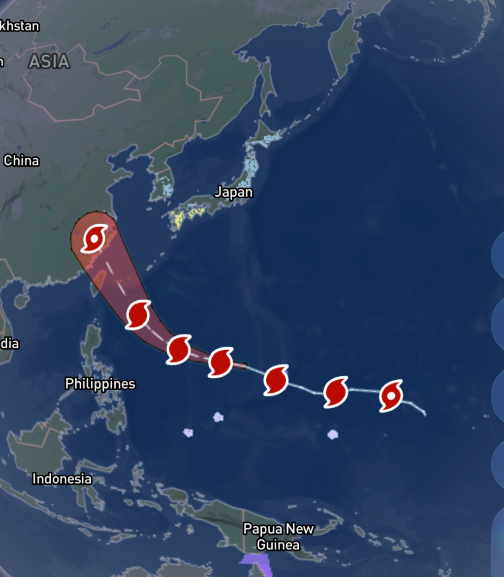
Bavi is expected to continue moving west-northwest across the western Pacific over the coming days. While gradual weakening is forecast, the typhoon is expected to remain an extremely dangerous storm capable of producing hurricane-force winds and flooding rainfall.
Forecast models indicate potential impacts for:
- Northern Philippines (outer rainbands and strong winds)
- Taiwan
- Ryukyu Islands
- Eastern China later this week
Even as wind speeds slowly decrease, the storm’s large circulation will continue generating dangerous surf, coastal flooding, and heavy rainfall well away from the center. (Reuters)
Expected Hazards
Residents along the forecast path should prepare for:
- Destructive hurricane-force winds
- Torrential rainfall capable of flash flooding
- Mudslides in mountainous terrain
- Dangerous storm surge in coastal communities
- Large battering waves and rip currents
- Extended power outages
- Downed trees and power lines
- Significant travel disruptions
Flooding often becomes the deadliest hazard during major tropical cyclones, especially after the strongest winds have passed.
How to Prepare
If you are in the forecast path of Typhoon Bavi:
- Monitor updates from your local meteorological agency.
- Charge mobile devices and backup batteries before conditions worsen.
- Stock enough food, drinking water, medications, and emergency supplies for several days.
- Secure outdoor furniture, signs, and loose objects.
- Avoid unnecessary travel during high winds and heavy rain.
- Never drive through flooded roadways—water depth and road damage can be impossible to judge.
- Be prepared for prolonged power outages and communication interruptions.
- Follow evacuation orders immediately if issued by local officials.
Marine Conditions
Extremely dangerous marine conditions continue across portions of the western Pacific. Seas remain exceptionally rough with powerful waves capable of producing life-threatening conditions for all vessels. Mariners should remain in port until official warnings have been lifted. (FOX Weather)
Final Thoughts
Super Typhoon Bavi serves as another reminder of the destructive power of western Pacific tropical cyclones. While the storm is forecast to slowly weaken over the coming days, it remains capable of producing widespread wind damage, flooding, and dangerous coastal conditions as it tracks toward Taiwan and eastern China. Residents throughout the forecast area should continue monitoring official forecasts and be ready to act quickly if conditions deteriorate.

Affiliate Disclosure: As an Amazon Associate, Radar Watch HQ earns from qualifying purchases.
Radar Watch HQ Top 5 Essential Emergency Preparedness Picks
Whether you’re preparing for severe thunderstorms, flash flooding, hurricanes, wildfires, or extended power outages, these five emergency essentials can help keep your household safer when severe weather strikes.
A portable power station provides reliable backup electricity during outages, allowing you to power phones, medical devices, laptops, lights, small appliances, and communication equipment without fuel.
Best for:
- Extended power outages
- Severe thunderstorms
- Hurricanes
- Winter storms
- Wildfires
2. Flood Protection Barriers & Sandless Flood Bags
Flood barriers help divert or absorb water before it enters garages, doorways, and low-lying areas. They deploy quickly and can help reduce property damage during flash flooding.
Best for:
- Flash Flood Warnings
- Heavy rainfall
- River flooding
- Coastal flooding
3. Rechargeable LED Flashlights
Bright, dependable flashlights are essential when the power goes out. Rechargeable or solar-powered models provide long-lasting illumination for navigating safely indoors and outdoors.
Best for:
- Overnight power outages
- Emergency evacuations
- Storm damage inspections
Keep phones, tablets, weather radios, and USB-powered devices charged when the electrical grid is unavailable. A solar power bank offers an additional charging option during prolonged emergencies.
Best for:
- Communication during outages
- Emergency weather alerts
- Travel and evacuation
A NOAA Weather Radio delivers official weather alerts directly from the National Weather Service, even when cellular networks or internet service are unavailable. It remains one of the most dependable ways to receive life-saving warnings.
Best for:
- Tornado warnings
- Severe thunderstorm warnings
- Flash flood warnings
- Hurricane alerts
- Winter storm emergencies
Why Radar Watch HQ Recommends These Essentials
At Radar Watch HQ, preparedness is just as important as staying informed. These five emergency essentials can help you stay connected, protect your property, and safely navigate severe weather events. Having supplies ready before storms arrive allows you to respond quickly when warnings are issued and conditions begin to deteriorate.