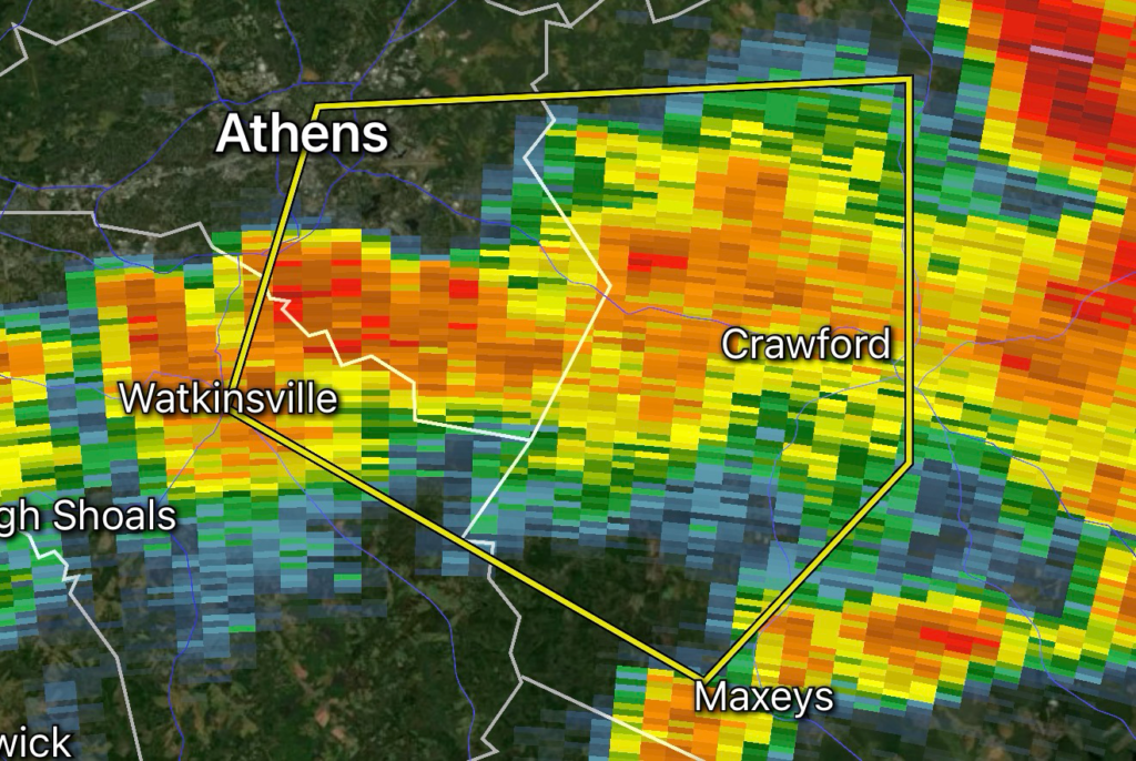
Residents across Clarke County, Oconee County, and Oglethorpe County, Georgia, should take immediate precautions as a Severe Thunderstorm Warning has been issued for the area. Strong thunderstorms capable of producing 60 mph wind gusts are moving through northeast Georgia, creating hazardous conditions for travel and outdoor activities.
The warning comes during an active stretch of summertime weather across north and central Georgia, where abundant heat and humidity continue to fuel repeated rounds of severe thunderstorms. Forecasts indicate that damaging straight-line winds remain the primary threat, although large hail, dangerous cloud-to-ground lightning, torrential rainfall, and localized flash flooding are also possible.
Main Hazards
- Wind Gusts: Up to 60 mph
- Large Hail: Possible with stronger storm cells
- Frequent Lightning: Dangerous for anyone outdoors
- Heavy Rain: May produce localized flash flooding in poor drainage areas
- Falling Trees & Power Outages: Possible due to strong wind gusts
Areas Included
The warning includes:
- Clarke County
- Oconee County
- Oglethorpe County
Communities including Athens, Watkinsville, Lexington, Winterville, and surrounding areas should closely monitor changing weather conditions.
Ongoing Severe Weather Pattern Across Georgia
Georgia has experienced an active weather pattern in recent weeks as extreme summer heat combines with tropical moisture to create an environment favorable for strong afternoon and evening thunderstorms. Meteorologists continue to monitor multiple rounds of storms capable of producing damaging winds, hail, frequent lightning, and localized flooding throughout north and central Georgia.
Safety Tips
If a Severe Thunderstorm Warning has been issued:
- Move indoors immediately.
- Stay away from windows.
- Secure loose outdoor objects.
- Avoid driving through flooded roadways.
- Unplug sensitive electronics if conditions allow.
- Keep multiple ways to receive weather alerts, including NOAA Weather Radio and mobile emergency notifications.
Remember that severe thunderstorms can strengthen rapidly and may produce dangerous conditions with little warning.
Stay Updated with Radar Watch HQ
Radar Watch HQ continues monitoring severe weather across Georgia and the Southeast. Check back frequently for updated warnings, radar analysis, storm tracking, and emergency preparedness information as conditions evolve.
⚡ Radar Watch HQ Essential Pick
Portable Power When the Power Is Out. Stay Ready for Every Storm.
Power outages can happen with little warning during severe thunderstorms, tornadoes, hurricanes, winter storms, and other extreme weather events. A reliable portable power station can help keep your essential devices running, including phones, weather radios, medical equipment, lights, and other essential devices when you need them most.
At Radar Watch HQ, we recommend keeping emergency backup power as part of every severe weather preparedness plan. Having a portable power station on hand can provide added peace of mind and help you stay informed, connected, and prepared until power is restored.
Be storm-ready before the next warning is issued.
⚡ Shop Here: Portable Power Stations
Stay Powered When the Grid Goes Down.
Explore Radar Watch HQ’s recommended portable power stations for severe weather, power outages, camping, and emergency preparedness.
🛒 Shop Portable Power Stations
Affiliate Disclosure: Radar Watch HQ participates in the Amazon Associates Program, including Amazon Creator Connections. As an Amazon Associate, we may earn a commission from qualifying purchases made through links on this page, at no additional cost to you. Our recommendations are based on products we believe offer value for weather preparedness and emergency readiness.