Severe Thunderstorm Warning Issued for Anderson and Pickens Counties, South Carolina
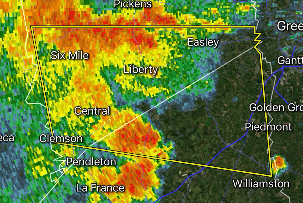
Residents across Anderson and Pickens counties in Upstate South Carolina are urged to take shelter immediately as the National Weather Service has issued a Severe Thunderstorm Warning for strong thunderstorms capable of producing wind gusts up to 60 mph and hail up to 0.75 inches in diameter. The storms are moving east across the region and could bring damaging conditions capable of downing trees and power lines.
Storm Hazards
- Wind Gusts: Up to 60 mph
- Hail: Up to 0.75 inches (penny-sized)
- Threats: Falling trees, scattered power outages, minor structural damage, hazardous driving conditions, and dangerous cloud-to-ground lightning.
Areas Impacted
The warning includes portions of:
- Anderson County
- Pickens County
Communities that may be affected include:
- Anderson
- Easley
- Clemson
- Pendleton
- Liberty
- Central
- Six Mile
- Norris
- Powdersville
- Seneca and nearby surrounding communities.
Weather Pattern Continues Across the Southeast
This warning is part of an active stretch of summer weather affecting the Southeast. A combination of abundant moisture, daytime heating, and unstable atmospheric conditions continues to fuel numerous thunderstorms capable of producing damaging wind gusts and frequent lightning across South Carolina and neighboring states. Additional storms may redevelop through the afternoon and evening.
Safety Tips
If you are within the warning area:
- Move indoors immediately.
- Stay away from windows and glass doors.
- Avoid using corded electrical appliances during the storm.
- Secure outdoor furniture and loose objects if it is safe to do so.
- Never drive through flooded roadways.
- If thunder roars, go indoors.
Stay Weather Aware
Radar Watch HQ will continue monitoring severe weather across South Carolina and provide updates as additional warnings are issued. Continue monitoring local forecasts, NOAA Weather Radio, and official National Weather Service alerts until the threat has passed.
Source: National Weather Service Greenville-Spartanburg.
⚡ Radar Watch HQ Essential Pick
Portable Power When the Power Is Out. Stay Ready for Every Storm.
Power outages can happen with little warning during severe thunderstorms, tornadoes, hurricanes, winter storms, and other extreme weather events. A reliable portable power station can help keep your essential devices running, including phones, weather radios, medical equipment, lights, and other essential devices when you need them most.
At Radar Watch HQ, we recommend keeping emergency backup power as part of every severe weather preparedness plan. Having a portable power station on hand can provide added peace of mind and help you stay informed, connected, and prepared until power is restored.
Be storm-ready before the next warning is issued.
⚡ Shop Here: Portable Power Stations
Stay Powered When the Grid Goes Down.
Explore Radar Watch HQ’s recommended portable power stations for severe weather, power outages, camping, and emergency preparedness.
🛒 Shop Portable Power Stations
Affiliate Disclosure: Radar Watch HQ participates in the Amazon Associates Program, including Amazon Creator Connections. As an Amazon Associate, we may earn a commission from qualifying purchases made through links on this page, at no additional cost to you. Our recommendations are based on products we believe offer value for weather preparedness and emergency readiness.