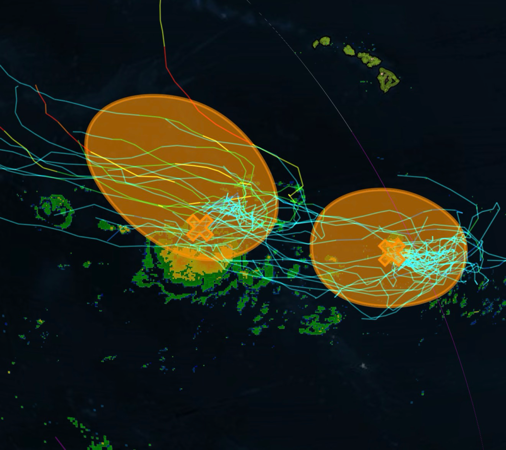
The National Hurricane Center is closely monitoring two separate tropical areas of interest in the Central Pacific, both located well away from the Hawaiian Islands. While neither system has developed into a tropical cyclone, both disturbances have a medium chance of formation over the next seven days and will be watched closely for potential development.
First Area of Interest: 50% Chance of Tropical Cyclone Formation
The first disturbance is located several hundred miles southwest of the Hawaiian Islands, where a trough of low pressure continues to generate disorganized showers and thunderstorms.
Environmental conditions are becoming increasingly favorable for gradual development. Forecasters indicate that this system could organize into a tropical depression later this week as it drifts slowly northwestward. Current projections keep the disturbance well southwest of the Hawaiian Islands, with no immediate threat to the island chain.
Residents and those with interests across the Central Pacific should continue monitoring forecasts as the system slowly evolves over the coming days.
Second Area of Interest: 60% Chance of Tropical Cyclone Formation
The second disturbance is located several hundred miles south of the Hawaiian Islands. Although shower and thunderstorm activity has decreased, the broad area of low pressure continues to be monitored for additional development.
Earlier satellite-derived wind observations indicated the system still lacks a well-defined surface circulation, preventing classification as a tropical depression at this time.
Despite the recent decrease in organization, forecasters say a tropical depression could still form during the next one to two days while the disturbance remains nearly stationary. However, environmental conditions are expected to become less favorable later this week, which will likely end any opportunity for further tropical development.
No Immediate Threat to Hawaii
At this time, neither tropical disturbance poses an immediate threat to the Hawaiian Islands. Both systems are forecast to remain well offshore while meteorologists continue evaluating satellite imagery, atmospheric conditions, and computer forecast models.
Tropical development forecasts can change quickly as environmental conditions evolve. Anyone with travel plans, marine interests, or residents across Hawaii should continue monitoring official forecasts throughout the week for any updates.
Radar Watch HQ will continue providing updates as these two tropical areas of interest develop and if either system strengthens into a tropical depression.
Radar Watch HQ Top 5 Marine Essentials
Affiliate Disclosure: As an Amazon Associate, Radar Watch HQ earns from qualifying purchases.
🌊 1. U.S. Coast Guard-Approved Life Jacket
A properly fitted life jacket is the most important piece of safety equipment for every passenger onboard.
Best for: Recreational boaters, anglers, kayakers, and paddleboarders.
⚓ 2. Marine Emergency Radio (NOAA Weather Radio)
Receive real-time NOAA Weather Radio alerts, marine forecasts, and emergency warnings—even when cell service is unavailable.
Best for: Offshore and coastal boating.
🔦 3. Rechargeable Waterproof LED Flashlight
A bright waterproof flashlight is essential for emergencies, low visibility, nighttime navigation, and signaling for help.
Best for: Every boat emergency kit.
🧰 4. Marine First Aid Kit
A waterproof first aid kit stocked with bandages, antiseptic, medications, and emergency supplies for injuries on the water.
Best for: Every vessel, regardless of size.
🧭 5. Waterproof Dry Bag
Protect phones, wallets, charts, keys, electronics, and emergency supplies from water damage during storms or rough seas.
Best for: Boaters, kayakers, paddleboarders, and beachgoers.
🛒 Radar Watch HQ Marine Safety Picks
Prepare before you head out on the water. Our recommended marine safety essentials can help keep you and your crew safe during changing weather conditions.