Severe Thunderstorm Warning Issued for Morgan, Salt Lake, Summit, Utah, Wasatch, and Weber Counties, Utah
Fast Facts: Wasatch Front & Mountain Storms
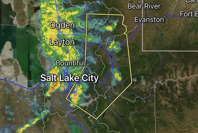
Impacted Counties: Morgan, Salt Lake, Summit, Utah, Wasatch, and Weber counties, Utah (Note: Prior warnings or sections affecting parts of Davis County have shifted or been canceled as the storm complex evolves).
Core Threats: Destructive straight-line wind gusts up to 70 mph, localized hail, heavy downpours, and dangerous cloud-to-ground lightning.
Issuing Authority: National Weather Service (NWS) Salt Lake City, UT.
Required Action: Seek immediate shelter inside a sturdy building. Stay away from windows and avoid driving on major corridors if high winds impair visibility.
A volatile weather setup across northern Utah has prompted urgent Severe Thunderstorm Warnings across a broad swath of the Wasatch Front and surrounding high country. The National Weather Service (NWS) in Salt Lake City has highlighted multiple counties—including Morgan, Salt Lake, Summit, Utah, Wasatch, and Weber counties—as destructive storm cells track across the region.
Residents across these areas should monitor local alerts closely, as atmospheric conditions are capable of producing violent wind gusts and localized damage.
Storm Dynamics: What to Expect Across the Impacted Counties
As convective activity fires up over the mountains and pushes across the valleys, storms are packing a serious punch. The primary hazards associated with these active warnings include:
1. Destructive Winds (Up to 70 MPH): High-end gusts of this magnitude can snap large tree limbs, uproot shallow trees, damage mobile homes, and strip siding or shingles from roofs. Power outages are likely where lines are impacted.
2. Brief Heavy Hail: While large hail is secondary to the extreme wind threat, penny-sized or smaller hail can still cause minor denting to vehicles and outdoor property.
3. Localized Flash Flooding & Poor Visibility: Torrential downpours can reduce highway visibility to near zero within minutes and cause temporary street flooding in urbanized low-lying spots.
Regional Breakdown and Corridor Impacts
The expansive warning zones cover major population centers, mountain passes, and critical transit corridors throughout northern Utah:
Salt Lake & Weber Counties: High-impact winds threaten densely populated urban zones, including Salt Lake City, West Valley City, Ogden, Sandy, and Layton. Major stretches of Interstate 15 (I-15) and Interstate 80 (I-80) experience severe crosswinds and sudden visibility drops.
Utah & Wasatch Counties: Mountain-adjacent valleys, Provo, Orem, and Heber City face sudden squalls rolling off the high terrain.
Morgan & Summit Counties: Rural communities, canyon routes, and recreational areas near Park City and Morgan are dealing with fast-moving, high-wind cells.
Note on Davis County: While neighboring eastern or broader parts of Davis County were previously under active threat, portions of those alerts have been modified or canceled as the main line shifts orientation. Always check real-time maps for the exact polygon boundary affecting your neighborhood.
Severe Weather Safety Protocol
When a Severe Thunderstorm Warning blankets your county, taking quick action minimizes risk:
Get Indoors: Abandon outdoor activities, sports fields, and open structures immediately. Move inside a sturdy, permanent home or commercial building.
Stay Away from Windows: 70 mph winds can easily shatter glass or hurl outdoor items against windows. Retreat to an interior ground-floor room or hallway.
Avoid Travel on Interstate Corridors: High-profile vehicles (semi-trucks, RVs, and trailers) are at a severe risk of tipping over under 70 mph crosswinds along I-15, I-80, and I-84. Delay travel until the storms clear.
Prepare for Outages: Keep emergency flashlights handy and avoid touching downed power lines.
Affiliate Disclosure: As an Amazon Associate, Radar Watch HQ earns from qualifying purchases.
Radar Watch HQ Top 5 Essential Emergency Preparedness Picks
Whether you’re preparing for severe thunderstorms, flash flooding, hurricanes, wildfires, or extended power outages, these five emergency essentials can help keep your household safer when severe weather strikes.
A portable power station provides reliable backup electricity during outages, allowing you to power phones, medical devices, laptops, lights, small appliances, and communication equipment without fuel.
Best for:
- Extended power outages
- Severe thunderstorms
- Hurricanes
- Winter storms
- Wildfires
2. Flood Protection Barriers & Sandless Flood Bags
Flood barriers help divert or absorb water before it enters garages, doorways, and low-lying areas. They deploy quickly and can help reduce property damage during flash flooding.
Best for:
- Flash Flood Warnings
- Heavy rainfall
- River flooding
- Coastal flooding
3. Rechargeable LED Flashlights
Bright, dependable flashlights are essential when the power goes out. Rechargeable or solar-powered models provide long-lasting illumination for navigating safely indoors and outdoors.
Best for:
- Overnight power outages
- Emergency evacuations
- Storm damage inspections
Keep phones, tablets, weather radios, and USB-powered devices charged when the electrical grid is unavailable. A solar power bank offers an additional charging option during prolonged emergencies.
Best for:
- Communication during outages
- Emergency weather alerts
- Travel and evacuation
A NOAA Weather Radio delivers official weather alerts directly from the National Weather Service, even when cellular networks or internet service are unavailable. It remains one of the most dependable ways to receive life-saving warnings.
Best for:
- Tornado warnings
- Severe thunderstorm warnings
- Flash flood warnings
- Hurricane alerts
- Winter storm emergencies
Why Radar Watch HQ Recommends These Essentials
At Radar Watch HQ, preparedness is just as important as staying informed. These five emergency essentials can help you stay connected, protect your property, and safely navigate severe weather events. Having supplies ready before storms arrive allows you to respond quickly when warnings are issued and conditions begin to deteriorate.