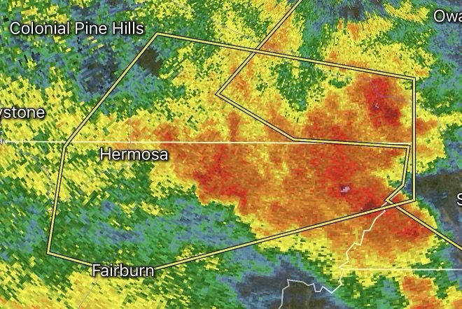
Severe Thunderstorm Warning Issued for Custer and Pennington Counties, South Dakota
Fast Facts: Black Hills Severe Weather
Impacted Counties: Custer County and Pennington County, South Dakota (including areas like Custer, Hermosa, and parts of the Black Hills region).
Primary Threats: Destructive straight-line winds up to 60 mph, quarter-sized hail (up to 1.00 inch), and torrential downpours.
Issuing Authority: National Weather Service (NWS) Rapid City, SD.
Required Action: Seek immediate shelter in a sturdy building. Stay away from windows and avoid prone flash-flood areas.
The dynamic and volatile weather patterns of western South Dakota can turn a peaceful afternoon in the Black Hills into a race against the elements in a matter of minutes. The National Weather Service (NWS) in Rapid City frequently issues Severe Thunderstorm Warnings for Custer and Pennington counties, putting residents, commuters, and tourists on high alert.
Knowing what these warnings mean, recognizing the risks to the local terrain, and taking prompt action can safeguard your family and property.
Understanding the Threats: What Impends in Custer and Pennington Counties?
When atmospheric instability peaks over the Black Hills and adjacent plains, storms can rapidly intensify. NWS Rapid City triggers warnings based on radar-indicated signatures or spotter reports highlighting specific, dangerous criteria:
1. Damaging Straight-Line Winds (Up to 60 MPH): Wind gusts of this magnitude can snap substantial tree branches, uproot trees in shallow mountain soils, and cause localized power outages by damaging utility lines.
2. Large Hail (Penny to Quarter Size): Hail stones ranging from 0.75 to 1.00 inch in diameter are common with these storms. This size can cause severe denting to vehicles, shatter vulnerable glass, and damage home exteriors or RV awnings.
3. Heavy Rainfall and Flash Flooding: Rapid runoff from intense rainfall can quickly overwhelm small streams, gulches, and low-water crossings—particularly dangerous for travelers navigating the canyons and rural stretches of the Black Hills.
Key Locations in the Crosshairs
Storm tracks moving across western South Dakota frequently impact heavily populated corridors as well as tourist hotspots. Areas routinely monitored under warnings for these two counties include:
Pennington County: Rapid City, Hermosa, Wall, and the Box Elder areas.
Custer County: Custer, Pringle, Fairburn, and regions bordering the Black Hills National Forest.
Because of the varied topography—ranging from rolling plains to rugged forested hills—local microclimates can cause storms to intensify unexpectedly.
Severe Weather Safety Checklist
When a Severe Thunderstorm Warning flashes on your phone or broadcasts on NOAA Weather Radio, take immediate precautions:
Seek Indoor Shelter: Move inside a permanent, sturdy structure immediately. Avoid open-air pavilions, tents, or unanchored structures.
Move Away From Windows: High winds can shatter glass or blow debris through windows. Retreat to an interior room on the lowest floor (like a hallway or bathroom).
Secure Outdoor Gear: If you have advanced notice, bring inside loose patio furniture, camping gear, and trash cans that could become airborne hazards.
Never Drive Into Floodwaters: Turn Around, Don’t Drown. Rapidly rising water can sweep vehicles off rural roads or mountain passes before you realize the depth.
Prepare for Power Disruptions: Keep flashlights, fully charged devices, and backup batteries handy in case lightning or falling tree limbs knock out local power grids.

Affiliate Disclosure: As an Amazon Associate, Radar Watch HQ earns from qualifying purchases.
Radar Watch HQ Top 5 Essential Emergency Preparedness Picks
Whether you’re preparing for severe thunderstorms, flash flooding, hurricanes, wildfires, or extended power outages, these five emergency essentials can help keep your household safer when severe weather strikes.
A portable power station provides reliable backup electricity during outages, allowing you to power phones, medical devices, laptops, lights, small appliances, and communication equipment without fuel.
Best for:
- Extended power outages
- Severe thunderstorms
- Hurricanes
- Winter storms
- Wildfires
2. Flood Protection Barriers & Sandless Flood Bags
Flood barriers help divert or absorb water before it enters garages, doorways, and low-lying areas. They deploy quickly and can help reduce property damage during flash flooding.
Best for:
- Flash Flood Warnings
- Heavy rainfall
- River flooding
- Coastal flooding
3. Rechargeable LED Flashlights
Bright, dependable flashlights are essential when the power goes out. Rechargeable or solar-powered models provide long-lasting illumination for navigating safely indoors and outdoors.
Best for:
- Overnight power outages
- Emergency evacuations
- Storm damage inspections
Keep phones, tablets, weather radios, and USB-powered devices charged when the electrical grid is unavailable. A solar power bank offers an additional charging option during prolonged emergencies.
Best for:
- Communication during outages
- Emergency weather alerts
- Travel and evacuation
A NOAA Weather Radio delivers official weather alerts directly from the National Weather Service, even when cellular networks or internet service are unavailable. It remains one of the most dependable ways to receive life-saving warnings.
Best for:
- Tornado warnings
- Severe thunderstorm warnings
- Flash flood warnings
- Hurricane alerts
- Winter storm emergencies
Why Radar Watch HQ Recommends These Essentials
At Radar Watch HQ, preparedness is just as important as staying informed. These five emergency essentials can help you stay connected, protect your property, and safely navigate severe weather events. Having supplies ready before storms arrive allows you to respond quickly when warnings are issued and conditions begin to deteriorate.