Emergency Alert: Tornado Warnings Issued for Linn County, Iowa – What You Need to Know
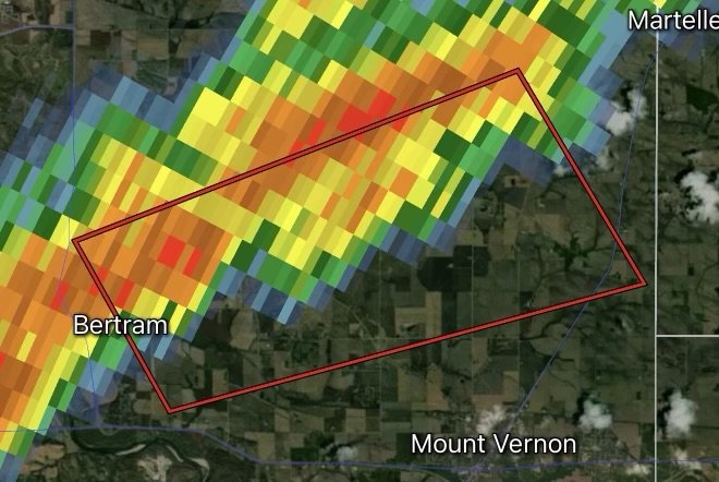
A volatile, high-energy weather pattern is sweeping across the Hawkeye State, bringing an aggressive round of severe weather to east-central Iowa. The National Weather Service (NWS) has issued urgent Tornado Warnings and severe weather alerts targeting Linn County and surrounding communities, putting residents on high alert as rotating thunderstorm cells track rapidly through the region.
Whether you live in Cedar Rapids, Marion, Hiawatha, Mount Vernon, or surrounding rural stretches, keeping informed and knowing how to respond the moment an emergency alert flashes on your phone can mean the difference between safety and disaster.
Fast Facts: Linn County Severe Weather & Tornado Alerts
Impacted Region: Linn County, Iowa, including major population hubs like Cedar Rapids, Marion, and surrounding rural townships (monitored by regional NWS forecast offices).
Core Threats: Damaging rotation capable of producing brief, sudden tornadoes, destructive straight-line winds exceeding 60–70 mph, large hail, and torrential downpours causing localized flash flooding.
Issuing Agency: National Weather Service (NWS) / Local Emergency Management.
Required Action: Seek immediate shelter in a sturdy permanent structure. Move to the lowest floor (basement or storm cellar) or an interior windowless room.
Understanding the Threat Across East-Central Iowa
When severe convective storm lines develop across the Midwest, rapid atmospheric changes can spin up mesovortices and low-level rotation within minutes. For residents across Linn County, these storms bring multiple concurrent hazards:
1. Radar-Indicated and Confirmed Rotation: When a Tornado Warning is issued, it means radar has detected intense rotation within a severe thunderstorm, or a tornado has been visually spotted by trained spotters or emergency management. Lead times can be mere minutes, making immediate action crucial.
2. Damaging Straight-Line Winds: Even outside the immediate path of rotation, powerful straight-line wind gusts can rip off roofs, down power lines, and snap mature trees, creating widespread utility disruptions and structural hazards.
3. Heavy Rain and Flash Flooding: Torrential downpours accompany these fast-moving cells, turning urban streets, low-water crossings, and poor-drainage areas into swift-moving hazards.
Tornado Safety Checklist: Protecting Your Family and Home
When a Tornado Warning is active for your community, every second counts. Follow these essential safety protocols immediately:
Move Underground or to the Lowest Floor: Head straight to a basement, storm cellar, or an interior room on the lowest level of a sturdy, permanent building (such as a bathroom, closet, or hallway).
Stay Away from Windows: Flying glass and exterior debris pose severe laceration hazards during high winds. Put as many walls between yourself and the outside as possible.
Cover Your Head and Neck: Protect yourself from falling debris or structural shifts by using heavy blankets, pillows, or mattresses. If available, wear bike helmets or hard hats.
Avoid Mobile Homes and Vehicles: Mobile homes do not provide adequate protection against tornadic winds. If you live in a mobile home or are caught driving on the road, leave immediately and seek shelter in a sturdy building or designated community shelter. Never try to outrun a tornado in a vehicle.
Keep Communication Devices Ready: Keep your smartphone emergency alerts enabled and tune a battery-powered or NOAA Weather Radio to your local frequency for continuous updates and all-clear notices.
Stay Informed and Connected
Weather conditions across Iowa can shift from calm to critical in a matter of minutes. Stay connected to trusted local news networks, monitor real-time radar feeds, and heed all instructions from local emergency management officials.
Stay safe, stay alert, and look out for your neighbors as Linn County navigates this active severe weather event!
Affiliate Disclosure: As an Amazon Associate, Radar Watch HQ earns from qualifying purchases.
Radar Watch HQ Top 5 Essential Emergency Preparedness Picks
Whether you’re preparing for severe thunderstorms, flash flooding, hurricanes, wildfires, or extended power outages, these five emergency essentials can help keep your household safer when severe weather strikes.
A portable power station provides reliable backup electricity during outages, allowing you to power phones, medical devices, laptops, lights, small appliances, and communication equipment without fuel.
Best for:
- Extended power outages
- Severe thunderstorms
- Hurricanes
- Winter storms
- Wildfires
2. Flood Protection Barriers & Sandless Flood Bags
Flood barriers help divert or absorb water before it enters garages, doorways, and low-lying areas. They deploy quickly and can help reduce property damage during flash flooding.
Best for:
- Flash Flood Warnings
- Heavy rainfall
- River flooding
- Coastal flooding
3. Rechargeable LED Flashlights
Bright, dependable flashlights are essential when the power goes out. Rechargeable or solar-powered models provide long-lasting illumination for navigating safely indoors and outdoors.
Best for:
- Overnight power outages
- Emergency evacuations
- Storm damage inspections
Keep phones, tablets, weather radios, and USB-powered devices charged when the electrical grid is unavailable. A solar power bank offers an additional charging option during prolonged emergencies.
Best for:
- Communication during outages
- Emergency weather alerts
- Travel and evacuation
A NOAA Weather Radio delivers official weather alerts directly from the National Weather Service, even when cellular networks or internet service are unavailable. It remains one of the most dependable ways to receive life-saving warnings.
Best for:
- Tornado warnings
- Severe thunderstorm warnings
- Flash flood warnings
- Hurricane alerts
- Winter storm emergencies
Why Radar Watch HQ Recommends These Essentials
At Radar Watch HQ, preparedness is just as important as staying informed. These five emergency essentials can help you stay connected, protect your property, and safely navigate severe weather events. Having supplies ready before storms arrive allows you to respond quickly when warnings are issued and conditions begin to deteriorate.