Severe Thunderstorms Develop Across Arizona and Nevada
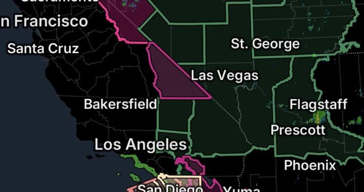
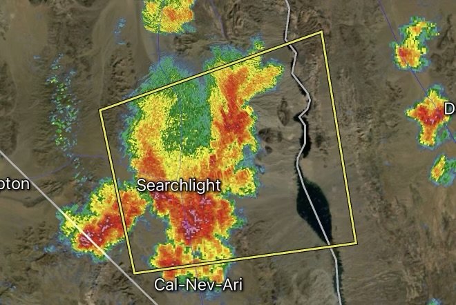
August 12, 2026 — Severe thunderstorms are impacting parts of the Southwest, including Clark County, Nevada, and Mohave County, Arizona, as atmospheric moisture, intense summer heat, and monsoon-season instability combine to create a volatile weather pattern.
For residents in and around the warning area, conditions can change quickly. Strong thunderstorms may bring damaging wind gusts, frequent lightning, torrential rainfall, flash flooding, and blowing dust.
Because storms can develop rapidly during the Southwest monsoon, residents should monitor updated weather information and be prepared to move indoors when thunderstorms approach.
How Monsoon Season Is Driving the Current Weather Pattern
The Southwest monsoon is a major factor behind the increase in thunderstorm activity across Arizona and neighboring areas.
During monsoon season, moisture moves northward from the Gulf of California, Gulf of Mexico, and eastern Pacific region. That additional moisture can interact with intense daytime heating and terrain to produce towering thunderstorms.
As moisture increases, the atmosphere can become more favorable for:
- Afternoon and evening thunderstorms
- Heavy downpours
- Frequent lightning
- Strong wind gusts
- Flash flooding
- Dust storms and reduced visibility
- Rapid changes in local weather conditions
Not every location receives heavy rain. In fact, some areas can experience dangerous winds and lightning while receiving little rainfall at the surface.
Why Extreme Heat Matters
Extreme summer heat plays an important role in the Southwest’s active weather pattern.
During the afternoon, strong sunshine heats the desert surface. That heating creates rising air and can contribute to atmospheric instability. When sufficient monsoon moisture is present, the combination can help thunderstorms rapidly intensify.
The result can be a challenging weather setup where very hot temperatures are followed by rapidly developing thunderstorms.
Heat can also increase the danger for people caught outdoors during a storm. Before thunderstorms arrive, residents may already be dealing with dangerous heat. Once storms develop, lightning, strong winds, flooding, and sudden temperature changes create additional hazards.
Clark County, Nevada: Storms Can Bring Multiple Hazards
Clark County, including the Las Vegas region and surrounding communities, can experience dramatic weather changes during the monsoon.
Thunderstorms developing over nearby mountains can produce strong outflow winds that travel considerable distances away from the storm itself.
These winds can create:
- Dangerous driving conditions
- Blowing dust
- Downed tree limbs
- Power disruptions
- Reduced visibility
- Sudden wind shifts
- Lightning hazards
Heavy rainfall can also overwhelm normally dry washes and drainage areas.
Mohave County, Arizona: Flash Flooding and Lightning Concerns
Mohave County is also vulnerable to monsoon thunderstorms, particularly where intense rainfall falls over dry terrain.
A location does not have to experience continuous rainfall to face a flooding threat. Water can quickly move downstream from higher terrain and storm locations.
Residents should avoid entering flooded roads, washes, or low-water crossings. Never assume a road is safe simply because the rain has stopped at your location.
Lightning is another major concern. Thunder can travel well beyond the heaviest part of a storm, meaning outdoor activities should be postponed when thunderstorms are nearby.
Heat + Monsoon Moisture = A Complicated Weather Pattern
One of the most important trends to watch during the Southwest monsoon is the interaction between heat and moisture.
The basic process can look like this:
Extreme heat → rising air → increasing instability → monsoon moisture → thunderstorm development → strong winds and heavy rainfall
However, the exact outcome varies from location to location. Some storms may produce intense rainfall and flooding, while others may primarily generate powerful outflow winds, dust, and lightning.
This variability makes radar and updated warnings especially important during active monsoon days.
What Residents Should Do During a Severe Thunderstorm
When a severe thunderstorm warning is issued for your area, take the warning seriously.
If You Are Outside
Move indoors as soon as possible. Avoid exposed areas, mountain ridges, open fields, and bodies of water.
If You Are Driving
Slow down and avoid flooded roads. Strong wind and blowing dust can dramatically reduce visibility, especially across desert highways.
During Lightning
Stay inside a sturdy building or enclosed vehicle. Avoid trees, open shelters, and other exposed locations.
During Flash Flooding
Never drive or walk through moving water. Floodwaters can be deeper and faster than they appear.
During Extreme Heat
Stay hydrated, limit strenuous outdoor activity, and remember that thunderstorms do not automatically eliminate the heat danger. Temperatures can remain dangerously high before and after storms.
The Bigger Southwest Weather Picture
The current setup highlights why monsoon season is one of the most dynamic periods of the year across Arizona and parts of Nevada.
The combination of extreme heat, moisture, terrain, and atmospheric instability can create thunderstorms with very different hazards from one community to another.
For residents of Clark County and Mohave County, staying weather-aware is particularly important during the afternoon and evening hours when storms can rapidly develop.
Conditions can change within minutes, so residents should continue monitoring local weather alerts and radar throughout the day.
Stay Weather Ready With Radar Watch HQ
Weather conditions across Arizona and Nevada can change quickly during monsoon season. Keep your phone charged, monitor severe weather alerts, and have a plan for getting indoors when thunderstorms approach.
Follow Radar Watch HQ for continuing severe weather coverage, developing alerts, radar updates, and important weather safety information. Stay alert. Stay informed. Stay weather ready.

Affiliate Disclosure: As an Amazon Associate, Radar Watch HQ earns from qualifying purchases.
Radar Watch HQ Top 5 Essential Emergency Preparedness Picks
Whether you’re preparing for severe thunderstorms, flash flooding, hurricanes, wildfires, or extended power outages, these five emergency essentials can help keep your household safer when severe weather strikes.
A portable power station provides reliable backup electricity during outages, allowing you to power phones, medical devices, laptops, lights, small appliances, and communication equipment without fuel.
Best for:
- Extended power outages
- Severe thunderstorms
- Hurricanes
- Winter storms
- Wildfires
2. Flood Protection Barriers & Sandless Flood Bags
Flood barriers help divert or absorb water before it enters garages, doorways, and low-lying areas. They deploy quickly and can help reduce property damage during flash flooding.
Best for:
- Flash Flood Warnings
- Heavy rainfall
- River flooding
- Coastal flooding
3. Rechargeable LED Flashlights
Bright, dependable flashlights are essential when the power goes out. Rechargeable or solar-powered models provide long-lasting illumination for navigating safely indoors and outdoors.
Best for:
- Overnight power outages
- Emergency evacuations
- Storm damage inspections
Keep phones, tablets, weather radios, and USB-powered devices charged when the electrical grid is unavailable. A solar power bank offers an additional charging option during prolonged emergencies.
Best for:
- Communication during outages
- Emergency weather alerts
- Travel and evacuation
A NOAA Weather Radio delivers official weather alerts directly from the National Weather Service, even when cellular networks or internet service are unavailable. It remains one of the most dependable ways to receive life-saving warnings.
Best for:
- Tornado warnings
- Severe thunderstorm warnings
- Flash flood warnings
- Hurricane alerts
- Winter storm emergencies
Why Radar Watch HQ Recommends These Essentials
At Radar Watch HQ, preparedness is just as important as staying informed. These five emergency essentials can help you stay connected, protect your property, and safely navigate severe weather events. Having supplies ready before storms arrive allows you to respond quickly when warnings are issued and conditions begin to deteriorate.