Tropical Watches Expand Across Gulf Waters
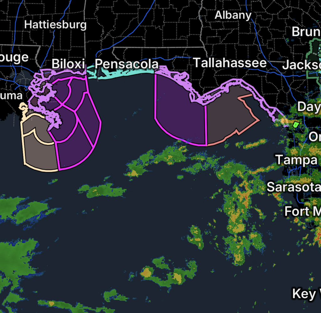
A growing area of the Gulf of Mexico is under tropical weather watches on Wednesday, October 7, 2026, as a tropical system threatens to bring worsening conditions to portions of the Florida and Louisiana Gulf Coast waters.
The watches highlight the potential for tropical-storm-force winds, hurricane-force winds, dangerous seas and rapidly deteriorating marine conditions.
Mariners in and around the affected waters should prepare now and closely monitor the latest official forecasts.
🌀 Tropical Storm Watch — Apalachee Bay and Nearby Waters
A Tropical Storm Watch covers portions of Apalachee Bay and surrounding Gulf waters, including:
- Coastal waters from Keaton Beach to the Ochlockonee River, Florida, out to 20 nautical miles
- Coastal waters from the Ochlockonee River to Apalachicola, Florida, out to 20 nautical miles
- Waters from the Suwannee River to Apalachicola, 20 to 60 nautical miles offshore
A Tropical Storm Watch means tropical-storm-force winds are possible within the watch area, generally within the next 48 hours.
Conditions could deteriorate quickly as the system approaches.
🌀 Hurricane Watch — Florida Panhandle Gulf Waters
A Hurricane Watch has been issued for several areas along the Florida Panhandle and adjacent offshore waters.
The affected areas include:
- Coastal waters from Mexico Beach to the Okaloosa-Walton County line, out 20 nautical miles
- Coastal waters from Mexico Beach to Apalachicola, out 20 nautical miles
- Waters from Mexico Beach to the Okaloosa-Walton County line, 20 to 60 nautical miles offshore
- Waters from Apalachicola to Mexico Beach, 20 to 60 nautical miles offshore
A Hurricane Watch means hurricane-force winds are possible within the specified area.
Mariners should not wait until conditions deteriorate to secure vessels and prepare for hazardous weather.
⚠️ Storm Watch and Tropical Storm Watch — Louisiana Waters
Farther west, watches also cover portions of the Louisiana offshore waters.
A Storm Watch and Tropical Storm Watch affect the coastal waters from the Southwest Pass of the Mississippi River to Port Fourchon, Louisiana, from 20 to 60 nautical miles offshore.
These waters could experience increasingly dangerous conditions as the tropical system develops and approaches the northern Gulf.
🌊 Dangerous Marine Conditions Possible
Tropical systems can rapidly transform normally manageable Gulf waters into dangerous conditions.
Mariners should prepare for:
- 🌊 Very rough and hazardous seas
- 💨 Strong tropical-storm-force winds
- 🌀 Potential hurricane-force winds
- 🌧️ Heavy rain reducing visibility
- ⚡ Thunderstorms and squalls
- 🌊 Dangerous waves and rapidly changing currents
- ⚓ Difficult conditions for smaller vessels
Small craft and recreational boaters are especially vulnerable to rapidly deteriorating conditions.
What Mariners Should Do Now
If your vessel is located within or near a watch area, preparations should begin before tropical-storm-force winds arrive.
🚤 Secure vessels: Move boats to safe harbor or complete mooring preparations.
⚓ Check mooring lines: Make sure dock lines and anchors can withstand worsening conditions.
📡 Monitor marine forecasts: Conditions can change quickly as the system approaches.
🛟 Don’t wait until the last minute: Once strong winds and rough seas arrive, marine preparations can become dangerous or impossible.
📱 Have multiple ways to receive alerts: Keep weather radios, phones and emergency communication devices ready.
Watch vs. Warning: What Does It Mean?
A Tropical Storm Watch means tropical-storm-force winds are possible.
A Hurricane Watch means hurricane-force winds are possible.
A Storm Watch indicates the potential for significant storm conditions and should be taken seriously by mariners.
A watch does not mean those conditions are guaranteed, but it means residents and mariners should be prepared for the possibility.
Essentials: Gulf Coast Marine Safety
🌊 Stay off the Gulf if conditions are deteriorating.
🚤 Secure boats early. Don’t wait until strong winds arrive.
⚠️ Take Hurricane Watches seriously. Conditions can worsen rapidly.
📡 Monitor official updates. Tropical systems can change track and intensity.
🌧️ Expect reduced visibility. Heavy rain and thunderstorms can make navigation dangerous.
🛟 Have emergency equipment ready. Life jackets, communications equipment and emergency supplies should be accessible.
Bottom Line
A broad area of the northern Gulf of Mexico is facing increasing tropical threats on October 7, 2026, with Tropical Storm Watches, Hurricane Watches and Storm Watches covering offshore waters from Louisiana across the Florida Panhandle and Apalachee Bay.
The watches signal the potential for dangerous winds, hazardous seas and rapidly deteriorating marine conditions.
Mariners should complete preparations now and continue monitoring official forecasts as the tropical system approaches.