Hurricane Isaias Strengthens to Category 1
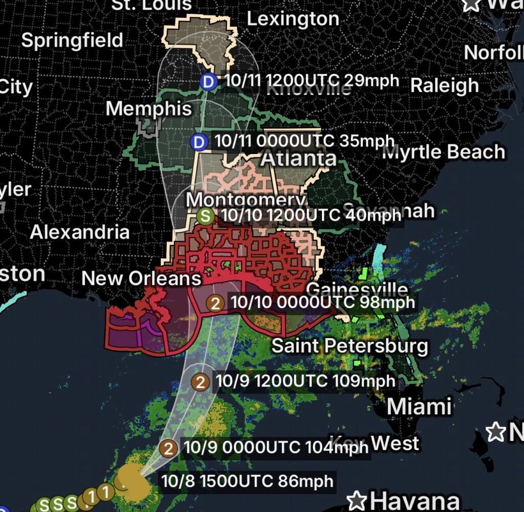
Hurricane Isaias is a Category 1 hurricane on Thursday, October 8, 2026, with a broad area of tropical hazards spreading across the northern Gulf Coast and Southeast.
Hurricane and tropical storm watches and warnings are in effect across portions of Alabama and northwest Florida, while tropical cyclone statements and flood watches extend farther inland across Alabama, Mississippi and Georgia.
The system is capable of producing damaging winds, dangerous coastal conditions, heavy rainfall and flooding.
Hurricane Warnings for Alabama and Northwest Florida Coastal Waters
A Hurricane Warning is in effect for portions of the coastal waters of Alabama and northwest Florida.
A Hurricane Warning means hurricane conditions are expected within the warning area. Mariners should take immediate action to protect vessels and avoid being caught on the Gulf as conditions deteriorate.
Dangerous marine conditions may include:
- 🌀 Hurricane-force winds
- 🌊 Extremely rough seas
- 🌧️ Heavy rain and thunderstorms
- ⚡ Squalls and reduced visibility
- 🌊 Dangerous surf and currents
Tropical Storm Warnings and Local Statements
A Tropical Storm Warning is in effect for portions of southwest Alabama, northwest Florida, south-central Alabama and inland southeast Mississippi.
Tropical Cyclone Local Statements have also been issued for these areas, providing residents with more detailed information about the expected hazards.
A Tropical Cyclone Local Statement may include information about wind threats, flooding, evacuation concerns, shelter information and other local impacts.
Residents should continue monitoring local emergency management officials and National Weather Service updates.
Hurricane Watch and Flooding Threats Continue
A Hurricane Watch is also in effect, indicating that hurricane-force winds are possible in the affected area.
Meanwhile, a Flood Watch covers portions of Alabama and northwest Florida.
Heavy tropical rainfall can create dangerous flooding even outside the immediate center of a hurricane. Repeated thunderstorms may overwhelm drainage systems, cause creeks and rivers to rise and create dangerous road conditions.
Turn around, don’t drown!
Florida Flood Watch and Southeast Georgia Rip Currents
A Flood Watch is also in effect for portions of east-central Florida.
Along the Southeast coast, a Rip Current Statement is in effect for the southeast Georgia beaches.
People visiting the coast should stay out of dangerous surf and follow beach flag systems and lifeguard instructions.
Georgia Faces Widespread Flooding Concerns
A broad Flood Watch covers portions of:
- Central Georgia
- East-central Georgia
- North-central Georgia
- Northeast Georgia
- Northwest Georgia
- Southeast Georgia
- West-central Georgia
A Tropical Cyclone Local Statement has also been issued for North and Central Georgia.
Heavy tropical rainfall could result in rapidly rising water, poor drainage flooding, flash flooding and dangerous travel conditions.
Residents should avoid flooded roads and be prepared to move to higher ground if flooding becomes a threat.
Flood Threat Extends Into Mississippi and West Tennessee
The tropical rainfall threat also extends west and north.
A Flood Watch is in effect for portions of Mississippi and West Tennessee.
Even locations well away from the Gulf Coast can experience significant rainfall from a tropical system. Residents should monitor rainfall rates and water levels, especially in low-lying and flood-prone areas.
Tropical Storm Watch for Ashland
A Tropical Storm Watch is also in effect for Ashland, highlighting the potential for tropical-storm-force conditions farther inland.
Residents in and around the watch area should continue monitoring official forecasts and be prepared for changing conditions.
Special Weather Statement for Illinois, Indiana and Kentucky
A Special Weather Statement covers a large area extending across parts of southern Illinois, southwestern Indiana and western Kentucky.
Communities and cities included in the statement include:
- Mount Vernon
- Fairfield
- Albion
- Mount Carmel
- Pinckneyville
- West Frankfort
- McLeansboro
- Carmi
- Carbondale
- Murphysboro
- Herrin
- Harrisburg
- Shawneetown
- Elizabethtown
- Fort Branch
- Petersburg
- Poseyville
- Evansville
- Boonville
- Rockport
- Marion
- Princeton
- Morganfield
- Dixon
- Madisonville
- Hopkinsville
- Henderson
- Owensboro
- Calhoun
- Greenville
- Elkton
Residents in these areas should monitor local weather conditions as the broader tropical system continues to influence the region.
What Residents Should Watch For
The most significant hazards will depend on location, but residents across the affected region should be prepared for:
🌬️ Strong Winds
Tropical-storm and hurricane-force winds can damage trees, power lines, roofs and outdoor structures.
Bring loose outdoor items inside and remain indoors during periods of dangerous winds.
🌧️ Heavy Rain and Flash Flooding
Tropical rainfall can quickly overwhelm drainage systems.
Avoid driving through flooded roads, even when the water appears shallow.
🌊 Coastal Flooding and Dangerous Surf
Storm-driven water, high waves and elevated tides can create dangerous coastal conditions.
Stay away from beaches, piers, jetties and other exposed coastal areas when warnings are in effect.
🌀 Rip Currents
Rip currents can pull swimmers away from shore and become especially dangerous during tropical weather.
The safest choice is to remain out of the water when dangerous surf conditions are present.
Essentials: Hurricane Isaias Safety
🏠 Shelter indoors: Stay inside during tropical-storm or hurricane-force winds and away from windows.
🔦 Prepare for power outages: Keep flashlights, batteries, chargers, food and water available.
🌧️ Watch for flooding: Never drive through flooded roads.
🚗 Move vehicles: If you are in a flood-prone area, move vehicles to higher ground before flooding begins.
🌊 Stay away from the coast: Dangerous surf, storm surge and rip currents can be deadly.
📱 Monitor official alerts: Keep phones charged and follow emergency management instructions.
🌀 Know your evacuation route: If evacuation orders are issued, leave promptly and use designated routes.
Bottom Line
Category 1 Hurricane Isaias is bringing a significant and widespread tropical threat across the Gulf Coast and Southeast on October 8, 2026.
Hurricane Warnings affect portions of the Alabama and northwest Florida coastal waters, while Tropical Storm Warnings, Hurricane Watches, Flood Watches and Tropical Cyclone Local Statements extend across Alabama, Florida, Mississippi and Georgia.
The flooding threat reaches farther inland into Mississippi, Tennessee, Illinois, Indiana and Kentucky, while dangerous rip currents continue along portions of the Southeast coast.
Residents should remain weather-aware, prepare for power outages and flooding, and follow all evacuation and emergency instructions from local officials.