Two Atlantic Systems Could Gain Strength This Week
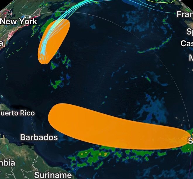
The Atlantic Basin is being monitored for two separate areas of low pressure that could develop into tropical depressions or storms over the coming days. One system is located east-southeast of Bermuda, while another tropical wave is moving across the eastern tropical Atlantic near the Cabo Verde Islands.
Although neither system currently poses an immediate land threat, conditions could change as both disturbances evolve.
Central Subtropical Atlantic: Brief Tropical Development Possible
Satellite wind data indicate that the broad low-level circulation associated with an area of low pressure remains a few hundred miles east-southeast of Bermuda.
Environmental conditions are currently only marginally conducive for additional development. However, the system could still organize enough to become a short-lived tropical depression or tropical storm through Tuesday.
Where Is the System Heading?
The low is expected to move generally northward and then north-northeastward, keeping it well northeast of Bermuda.
By Wednesday, the system is forecast to move over colder ocean waters. Cooler waters generally provide less energy for tropical development, and this transition is expected to significantly reduce the system’s chances of becoming stronger.
At this time, the disturbance is not expected to become a significant threat to Bermuda or the U.S. East Coast.
Eastern Tropical Atlantic: A System Worth Watching
Farther east, a tropical wave and associated area of low pressure is located a few hundred miles southeast of the Cabo Verde Islands.
The disturbance is currently producing disorganized showers and thunderstorms, indicating that the circulation has not yet become well organized.
However, conditions are forecast to gradually become more favorable for development.
Potential Development Later This Week
A tropical depression could form by the middle to latter portions of the week as the system moves westward to west-northwestward across the eastern and central tropical Atlantic.
The disturbance is expected to travel at approximately 15 to 20 mph, meaning it could cover a substantial distance across the Atlantic during the coming days.
Because the system is still several days away from potentially reaching areas farther west, there is considerable uncertainty regarding its eventual strength, track and potential impacts.
Why Tropical Development Can Change Quickly
Tropical systems require a combination of warm ocean water, sufficient atmospheric moisture, low wind shear and favorable upper-level conditions.
When these ingredients come together, thunderstorms can become more organized around a low-pressure center. As convection becomes concentrated, the circulation can strengthen and potentially transition from a tropical disturbance into a tropical depression and eventually a tropical storm.
Conversely, cooler water, dry air or increasing wind shear can disrupt thunderstorms and prevent development.
That is particularly important for the system east-southeast of Bermuda, which is expected to encounter colder waters by Wednesday.
What This Means for the Atlantic Basin
For now, neither disturbance represents an immediate threat to the continental United States. Nevertheless, the eastern tropical Atlantic system deserves continued attention because environmental conditions are expected to become more favorable later this week.
Meanwhile, the subtropical low near Bermuda could briefly acquire tropical characteristics before losing its opportunity for development over colder waters.
The Atlantic remains active, and conditions can evolve quickly during the peak portion of hurricane season.
Radar Watch HQ Final Thoughts
The Atlantic Basin is presenting two different tropical-development scenarios: one system near Bermuda that could briefly strengthen before weakening over colder water, and another farther east that may have a better opportunity to organize later this week.
Radar Watch HQ will continue monitoring both systems as their organization, movement and environmental conditions change.
Stay weather-aware, follow official forecasts, and check back with Radar Watch HQ for the latest tropical weather analysis and updates.